దస్త్రం:1904 Map showing Ukraine region before unification.pdf
ఈ ఫైలు PDF కు చెందిన ఈ మునుజూపు JPG పరిమాణం: 625 × 600 పిక్సెళ్ళు. ఇతర రిజల్యూషన్లు: 250 × 240 పిక్సెళ్ళు | 500 × 480 పిక్సెళ్ళు | 716 × 687 పిక్సెళ్ళు.
అసలు దస్త్రం (716 × 687 పిక్సెళ్ళు, ఫైలు పరిమాణం: 4.79 MB, MIME రకం: application/pdf)
This is a file from the Wikimedia Commons. Information from its description page there is shown below. Commons is a freely licensed media file repository. You can help. |
సారాంశం
| వివరణ |
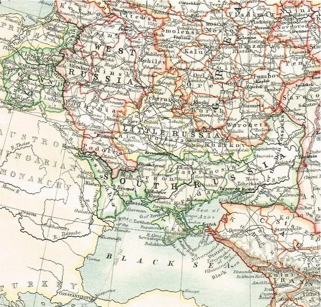
English: 1904 map showing separate administrative units, governorships,and geographic regions of Little Russia, South Russia and West Russia within the Russian Empire prior to Ukraine's independence 1917-1921. |
| తేదీ | |
| మూలం | 1904 Map Plate by W.& A.K. Johnston published in "The World-Wide Atlas" |
| కర్త | Photo by Paul Hundal |
లైసెన్సింగ్
This media file is in the public domain in the United States. This applies to U.S. works where the copyright has expired, often because its first publication occurred prior to January 1, 1929, and if not then due to lack of notice or renewal. See this page for further explanation.
|
 | |
 |
This image might not be in the public domain outside of the United States; this especially applies in the countries and areas that do not apply the rule of the shorter term for US works, such as Canada, Mainland China (not Hong Kong or Macao), Germany, Mexico, and Switzerland. The creator and year of publication are essential information and must be provided. See Wikipedia:Public domain and Wikipedia:Copyrights for more details.
|
ఫైలు చరితం
తేదీ/సమయం ను నొక్కి ఆ సమయాన ఫైలు ఎలా ఉండేదో చూడవచ్చు.
| తేదీ/సమయం | నఖచిత్రం | కొలతలు | వాడుకరి | వ్యాఖ్య | |
|---|---|---|---|---|---|
| ప్రస్తుత | 17:21, 8 ఫిబ్రవరి 2015 |  | 716 × 687 (4.79 MB) | Paulhundal | User created page with UploadWizard |
లింకులు
కింది పేజీలలో ఈ ఫైలుకు లింకులు ఉన్నాయి:
సార్వత్రిక ఫైలు వాడుక
ఈ దస్త్రాన్ని ఈ క్రింది ఇతర వికీలు ఉపయోగిస్తున్నాయి: