దస్త్రం:Canary Islands map by William Dampier 1699 - Project Gutenberg eText 15675.jpg

అసలు దస్త్రం (500 × 732 పిక్సెళ్ళు, ఫైలు పరిమాణం: 88 KB, MIME రకం: image/jpeg)
This is a file from the Wikimedia Commons. Information from its description page there is shown below. Commons is a freely licensed media file repository. You can help. |
సారాంశం
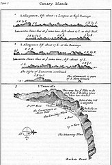
Map of the Canary Islands by William Dampier, 1699 (Project Gutenberg eText 15675).
From http://www.gutenberg.org/etext/15675/
లైసెన్సింగ్
| This image comes from the Project Gutenberg archives. This is an image that has come from a book or document for which the American copyright has expired and this image is in the public domain in the United States and possibly other countries.
This eBook is for the use of anyone anywhere at no cost and with almost no restrictions whatsoever. You may copy it, give it away or re-use it under the terms of the Project Gutenberg License included with this eBook or online at www.gutenberg.net. |
ఫైలు చరితం
తేదీ/సమయం ను నొక్కి ఆ సమయాన ఫైలు ఎలా ఉండేదో చూడవచ్చు.
| తేదీ/సమయం | నఖచిత్రం | కొలతలు | వాడుకరి | వ్యాఖ్య | |
|---|---|---|---|---|---|
| ప్రస్తుత | 14:30, 12 జూన్ 2005 | | 500 × 732 (88 KB) | Tagishsimon | Canary Islands map by William Dampier 1699 - Project Gutenberg eText 15675 From http://www.gutenberg.org/etext/15675/ {{PD}} Category:Maps |
లింకులు
కింది పేజీలలో ఈ ఫైలుకు లింకులు ఉన్నాయి:
సార్వత్రిక ఫైలు వాడుక
ఈ దస్త్రాన్ని ఈ క్రింది ఇతర వికీలు ఉపయోగిస్తున్నాయి:
- bn.wikipedia.org లో వాడుక
- bs.wikipedia.org లో వాడుక
- de.wikipedia.org లో వాడుక
- en.wikipedia.org లో వాడుక
- es.wikipedia.org లో వాడుక
- fr.wikipedia.org లో వాడుక
- ga.wikipedia.org లో వాడుక
- hr.wikipedia.org లో వాడుక
- it.wikipedia.org లో వాడుక
- sh.wikipedia.org లో వాడుక
- tt.wikipedia.org లో వాడుక