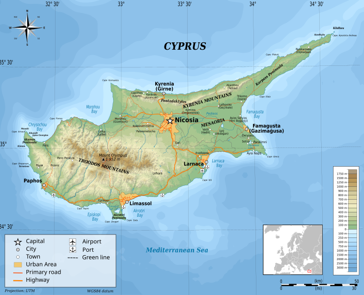
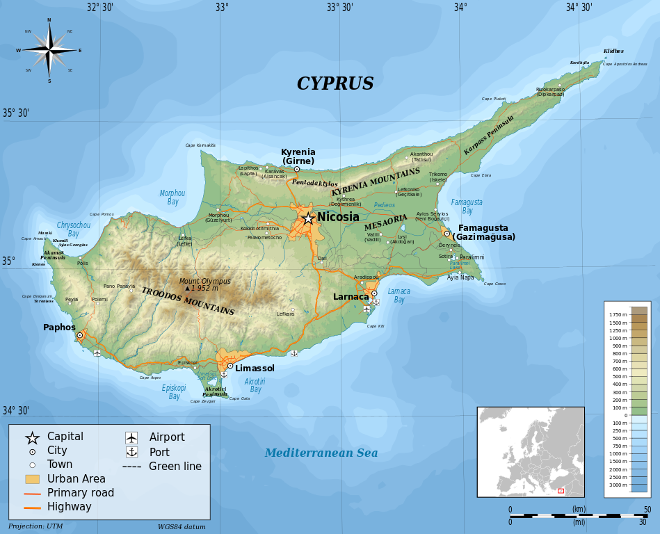
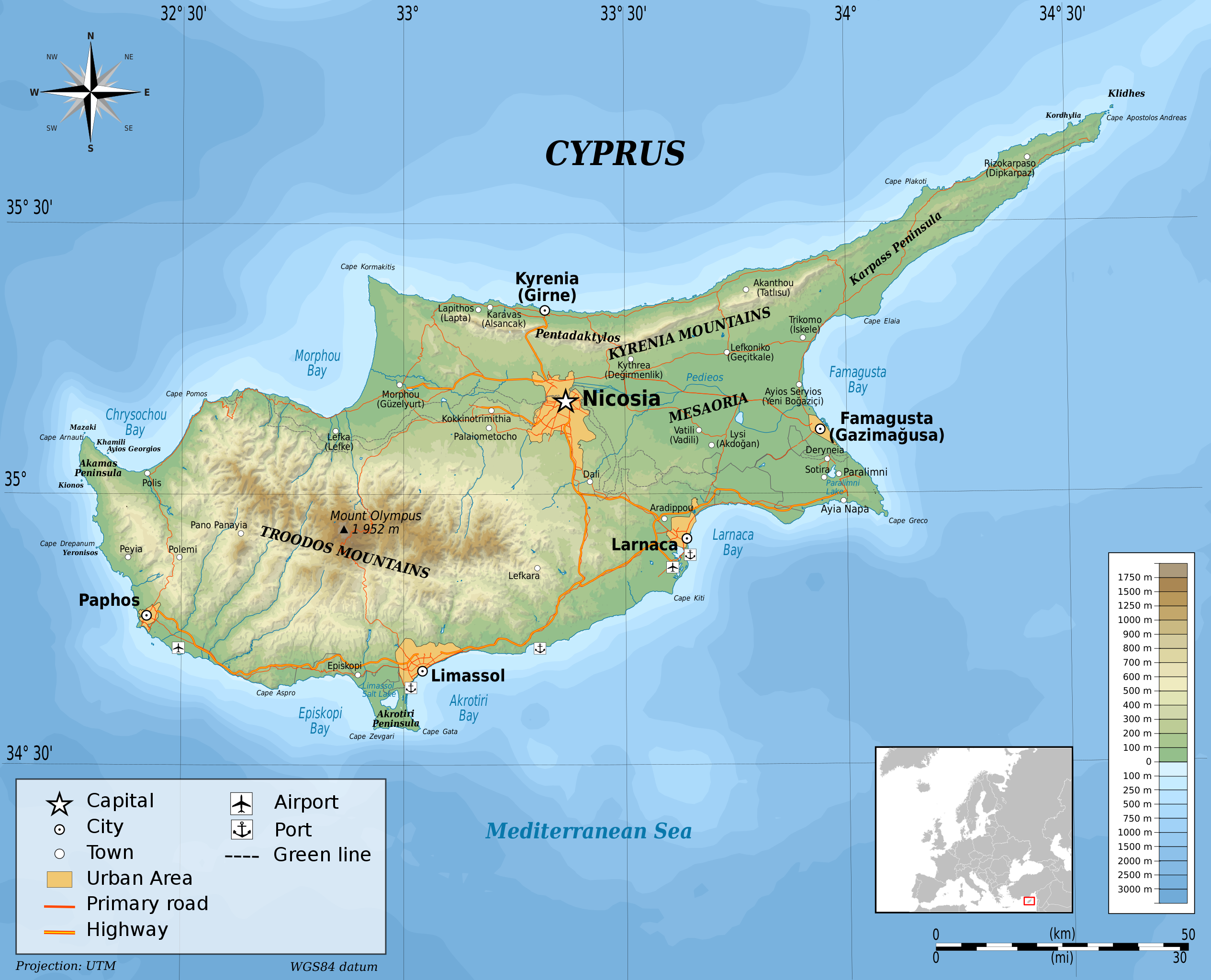
దస్త్రం:Cyprus-topographic map-en.svg

ఈ ఫైలు SVG కు చెందిన ఈ మునుజూపు PNG పరిమాణం: 741 × 600 పిక్సెళ్ళు. ఇతర రిజల్యూషన్లు: 297 × 240 పిక్సెళ్ళు | 593 × 480 పిక్సెళ్ళు | 949 × 768 పిక్సెళ్ళు | 1,265 × 1,024 పిక్సెళ్ళు | 2,530 × 2,048 పిక్సెళ్ళు | 2,028 × 1,642 పిక్సెళ్ళు.
అసలు దస్త్రం (SVG ఫైలు, నామమాత్రంగా 2,028 × 1,642 పిక్సెళ్ళు, ఫైలు పరిమాణం: 3.15 MB)
This is a file from the Wikimedia Commons. Information from its description page there is shown below. Commons is a freely licensed media file repository. You can help. |
సారాంశం
| వివరణ |
English: Topographic map of Cyprus Français : Carte topographique de Chypre
UTM projection, WGS84 datum Geographic limits of the map:
|
| తేదీ | |
| మూలం |
స్వంత కృతి Sources of data:
|
| కర్త | Ikonact |

|
This SVG file contains embedded text that can be translated into your language, using any capable SVG editor, text editor or the SVG Translate tool. For more information see: About translating SVG files. |
W3C-validity not checked.
లైసెన్సింగ్
నేను, ఈ కృతి యొక్క కాపీహక్కుదారుని, దీన్ని ఈ లైసెన్సు క్రింద ఇందుమూలముగా ప్రచురిస్తున్నాను:
ఈ దస్త్రం క్రియేటివ్ కామన్స్ Attribution-Share Alike 3.0 Unported లైసెన్సు క్రింద లభ్యం.
- ఇలా చేసేందుకు మీకు స్వేచ్ఛ ఉంది:
- పంచుకోడానికి – ఈ కృతిని కాపీ చేసుకోవచ్చు, పంపిణీ చేయవచ్చు, ప్రసారమూ చేయవచ్చు
- రీమిక్స్ చేయడానికి – కృతిని అనుకరించడానికి
- క్రింది షరతులకు లోబడి:
- ఆపాదింపు – సముచితమైన శ్రేయస్సును ఇవ్వాలి, లైసెన్సుకు లింకు ఇవ్వాలి, మార్పులేమైనా చేస్తే వాటిని సూచించాలి. అందుకు సముచితమైన పద్ధతి దేన్నైనా అవలంబించవచ్చు. కానీ మీకూ మీ వాడుకకూ హక్కుదారు అనుమతించారు అనే అర్థం వచ్చేటట్లుగా మాత్రం కాదు.
- share alike – మీరు ఈ కృతిని అనుకరిస్తే, మారిస్తే, లేదా మెరుగుపరిస్తే తత్ఫలిత కృతిని ఇదే లైసెన్సు లేదా దీనికి అనుగుణ్యమైన లైసెన్సు క్రింద మాత్రమే పంపిణీ చేయాలి.
ఫైలు చరితం
తేదీ/సమయం ను నొక్కి ఆ సమయాన ఫైలు ఎలా ఉండేదో చూడవచ్చు.
| తేదీ/సమయం | నఖచిత్రం | కొలతలు | వాడుకరి | వ్యాఖ్య | |
|---|---|---|---|---|---|
| ప్రస్తుత | 20:28, 4 సెప్టెంబరు 2014 | | 2,028 × 1,642 (3.15 MB) | Ikonact | valid svg |
| 07:51, 1 సెప్టెంబరు 2014 |  | 2,028 × 1,642 (2.94 MB) | Ikonact | bathymetry correction | |
| 22:23, 31 ఆగస్టు 2014 |  | 2,028 × 1,642 (3.17 MB) | Ikonact | better quality, more geographic names | |
| 23:12, 29 ఆగస్టు 2014 |  | 2,028 × 1,642 (3.07 MB) | Ikonact | more names added | |
| 20:09, 29 ఆగస్టు 2014 |  | 2,028 × 1,642 (3.05 MB) | Ikonact | names of mountains | |
| 17:51, 29 ఆగస్టు 2014 |  | 2,028 × 1,642 (3.05 MB) | Ikonact | names placed correctly | |
| 08:26, 4 మే 2014 |  | 2,028 × 1,642 (3.05 MB) | Fern 24 | Uploaded wrong version. | |
| 08:16, 4 మే 2014 |  | 2,028 × 1,642 (3.05 MB) | Fern 24 | Fixed typos, aligned and repositioned a few labels. | |
| 21:19, 5 నవంబరు 2012 |  | 2,028 × 1,642 (3.05 MB) | Ikonact | User created page with UploadWizard |
లింకులు
కింది పేజీలలో ఈ ఫైలుకు లింకులు ఉన్నాయి:
సార్వత్రిక ఫైలు వాడుక
ఈ దస్త్రాన్ని ఈ క్రింది ఇతర వికీలు ఉపయోగిస్తున్నాయి:
- el.wikipedia.org లో వాడుక
- en.wikipedia.org లో వాడుక
- User:Dimadick
- User:Dan Koehl
- User:Harry Wood
- User:PaulinSaudi
- User:Radagast
- User:Sjc196
- User:Pepoluan
- Wikipedia:WikiProject Maps
- User:BrendanRyan
- User:Spicyjack
- User:Jusjih
- User:Acad Ronin
- User:Skal
- User:Steve Farrell
- User:Ranma9617
- User:Jaques O. Carvalho
- User:Ua747sp
- User:AlexTheMartian
- User:Rashed
- User:Professorbikeybike
- User:Saga City
- User:Mikeaitch
- User:Flyingcheese
- User:Parihav
- User:Tabletop
- User:Makaristos
- User:Njk
- User:Spellcheck
- User:Riadlem
- User:Mukkakukaku
- User:Mjvan12
- User:Jared Preston
- User:N8foo
- User:Epolk
- User:Gcapp1959
- User:Toucan6
- User:Kasper Holl
- User:Petros63
- User:Bradybd
- User:Schzmo
- User:Mysid
- User:Burwellian
- User:Tigershrike
- User:Le Anh-Huy
- User:Kmusser
- User:Chingwakabungya
- User:Scotthatton
- User:HoratioVitero
- User:Ottar~enwiki
ఈ దస్త్రపు మరింత సార్వత్రిక వాడుకను చూడండి.