దస్త్రం:France-Constituent-Lands.png

ఈ మునుజూపు పరిమాణం: 606 × 599 పిక్సెళ్ళు. ఇతర రిజల్యూషన్లు: 243 × 240 పిక్సెళ్ళు | 485 × 480 పిక్సెళ్ళు | 777 × 768 పిక్సెళ్ళు | 1,035 × 1,024 పిక్సెళ్ళు | 2,071 × 2,048 పిక్సెళ్ళు | 3,337 × 3,300 పిక్సెళ్ళు.
అసలు దస్త్రం (3,337 × 3,300 పిక్సెళ్ళు, ఫైలు పరిమాణం: 382 KB, MIME రకం: image/png)
This is a file from the Wikimedia Commons. Information from its description page there is shown below. Commons is a freely licensed media file repository. You can help. |

|
This map image could be re-created using vector graphics as an SVG file. This has several advantages; see Commons:Media for cleanup for more information. If an SVG form of this image is available, please upload it and afterwards replace this template with
{{vector version available|new image name}}.
It is recommended to name the SVG file “France-Constituent-Lands.svg”—then the template Vector version available (or Vva) does not need the new image name parameter. |
సారాంశం
| వివరణ |
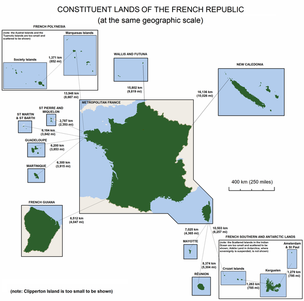
English: The constituent lands of the French Republic |
| తేదీ | |
| మూలం | స్వంత కృతి |
| కర్త | Godefroy |
| ఇతర కూర్పులు |
|

లైసెన్సింగ్
నేను, ఈ కృతి యొక్క కాపీహక్కుదారుని, దీన్ని ఇందుమూలముగా ఈ లైసెన్సుల క్రింద ప్రచురిస్తున్నాను:

|
ఈ కృతి యొక్క కర్తనైన నేను, ఇక నుండీ ఈ కృతిని కాపీ చేసుకోవడానికి, పంచి పెట్టడానికి మరియు/లేదా మార్పులు-చేర్పులు చేసుకోవడానికి GFDL, లైసెన్సు వెర్షను 1.2 లేదా దాని తరువాత స్వేచ్చా సాఫ్టువేరు ఫౌండేషను విడుదలచేసే ఏ GFDL లైసెన్సు ద్వారా నయినా అనుమతి ఇస్తున్నాను; ఈ కృతిలో మార్చకూడని బాగాలు లేవు, Front-Cover పాఠం లేదు, Back-Cover పాఠం లేదు. ఈ లైసెన్సు యొక్క పత్రం నకలును "జిఎన్యూ ఉచిత డాక్యుమెంటేషను లైసెన్సు" అని పిలుస్తున్న విభాగంలో ఉంది. |
| ఈ దస్త్రం క్రియేటివ్ కామన్స్ Attribution-Share Alike 3.0 Unported లైసెన్సు క్రింద లభ్యం. | ||
| ||
| GFDL లైసెన్సు తాజాకరణలో భాగంగా ఈ దస్త్రానికి ఈ లైసెన్సింగు ట్యాగుని చేర్చారు. |
పైవాటిలో మీకు నచ్చిన లైసెన్సునును ఎంచుకోవచ్చు.
ఫైలు చరితం
తేదీ/సమయం ను నొక్కి ఆ సమయాన ఫైలు ఎలా ఉండేదో చూడవచ్చు.
| తేదీ/సమయం | నఖచిత్రం | కొలతలు | వాడుకరి | వ్యాఖ్య | |
|---|---|---|---|---|---|
| ప్రస్తుత | 15:47, 7 నవంబరు 2010 | | 3,337 × 3,300 (382 KB) | Rosss | Moved French language map to a separate file |
| 02:58, 6 సెప్టెంబరు 2010 |  | 3,337 × 3,300 (299 KB) | Hypersite | Correction a few mistakes and showing of forgotten territories. -- Correction de petites erreurs et ajouts de territoires oublié. | |
| 15:52, 17 ఏప్రిల్ 2008 |  | 3,337 × 3,300 (382 KB) | Godefroy~commonswiki | {{Information |Description= The constituent lands of the French Republic |Source=self-made |Date= April 17, 2008 |Author= Godefroy |Permission= |other_versions= }} |
లింకులు
కింది పేజీలలో ఈ ఫైలుకు లింకులు ఉన్నాయి:
సార్వత్రిక ఫైలు వాడుక
ఈ దస్త్రాన్ని ఈ క్రింది ఇతర వికీలు ఉపయోగిస్తున్నాయి:
- an.wikipedia.org లో వాడుక
- ast.wikipedia.org లో వాడుక
- br.wikipedia.org లో వాడుక
- cs.wikipedia.org లో వాడుక
- de.wikipedia.org లో వాడుక
- en.wikipedia.org లో వాడుక
- en.wikibooks.org లో వాడుక
- es.wikipedia.org లో వాడుక
- et.wikipedia.org లో వాడుక
- eu.wikipedia.org లో వాడుక
- fa.wikipedia.org లో వాడుక
- fr.wikipedia.org లో వాడుక
- gl.wikipedia.org లో వాడుక
- he.wikipedia.org లో వాడుక
- hi.wikipedia.org లో వాడుక
- hy.wikipedia.org లో వాడుక
- id.wikipedia.org లో వాడుక
- ja.wikipedia.org లో వాడుక
- ka.wikipedia.org లో వాడుక
- km.wikipedia.org లో వాడుక
- lfn.wikipedia.org లో వాడుక
- lld.wikipedia.org లో వాడుక
- lv.wikipedia.org లో వాడుక
- ms.wikipedia.org లో వాడుక
- nn.wikipedia.org లో వాడుక
- no.wikipedia.org లో వాడుక
- pdc.wikipedia.org లో వాడుక
ఈ దస్త్రపు మరింత సార్వత్రిక వాడుకను చూడండి.