దస్త్రం:GökturksAD551-572.png

ఈ మునుజూపు పరిమాణం: 800 × 467 పిక్సెళ్ళు. ఇతర రిజల్యూషన్లు: 320 × 187 పిక్సెళ్ళు | 640 × 373 పిక్సెళ్ళు | 1,024 × 597 పిక్సెళ్ళు | 1,644 × 959 పిక్సెళ్ళు.
అసలు దస్త్రం (1,644 × 959 పిక్సెళ్ళు, ఫైలు పరిమాణం: 28 KB, MIME రకం: image/png)
This is a file from the Wikimedia Commons. Information from its description page there is shown below. Commons is a freely licensed media file repository. You can help. |
సారాంశం
| వివరణ |
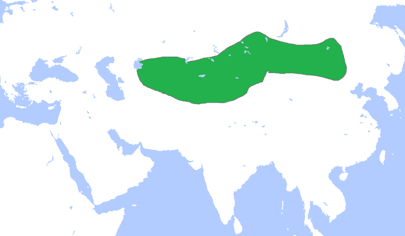
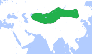
English: Locator map of the Gökturks, c. 551-572.
(Partially based on Atlas of World History (2007) - The World 500-750, map) |
| తేదీ | |
| మూలం | స్వంత కృతి |
| కర్త | Gabagool |
లైసెన్సింగ్
నేను, ఈ కృతి యొక్క కాపీహక్కుదారుని, దీన్ని ఈ లైసెన్సు క్రింద ఇందుమూలముగా ప్రచురిస్తున్నాను:
ఈ ఫైలు అనుమతి సాధారణ సృజనాత్మకము అపాదింపు ౩.౦ ఆన్-పోర్టెడ్ యందు అనుమతించబడినది.
- ఇలా చేసేందుకు మీకు స్వేచ్ఛ ఉంది:
- పంచుకోడానికి – ఈ కృతిని కాపీ చేసుకోవచ్చు, పంపిణీ చేయవచ్చు, ప్రసారమూ చేయవచ్చు
- రీమిక్స్ చేయడానికి – కృతిని అనుకరించడానికి
- క్రింది షరతులకు లోబడి:
- ఆపాదింపు – సముచితమైన శ్రేయస్సును ఇవ్వాలి, లైసెన్సుకు లింకు ఇవ్వాలి, మార్పులేమైనా చేస్తే వాటిని సూచించాలి. అందుకు సముచితమైన పద్ధతి దేన్నైనా అవలంబించవచ్చు. కానీ మీకూ మీ వాడుకకూ హక్కుదారు అనుమతించారు అనే అర్థం వచ్చేటట్లుగా మాత్రం కాదు.
ఫైలు చరితం
తేదీ/సమయం ను నొక్కి ఆ సమయాన ఫైలు ఎలా ఉండేదో చూడవచ్చు.
| తేదీ/సమయం | నఖచిత్రం | కొలతలు | వాడుకరి | వ్యాఖ్య | |
|---|---|---|---|---|---|
| ప్రస్తుత | 14:36, 18 మార్చి 2021 | | 1,644 × 959 (28 KB) | HistoryofIran | rv, user is banned |
| 14:08, 18 మార్చి 2021 |  | 1,644 × 959 (54 KB) | TurkicHeritage | Reverted to version as of 12:36, 18 March 2021 (UTC) | |
| 12:43, 18 మార్చి 2021 |  | 1,644 × 959 (28 KB) | HistoryofIran | rv, vandalism | |
| 12:36, 18 మార్చి 2021 |  | 1,644 × 959 (54 KB) | HistoryofHumann | Reverted to the original uploaded version. Changes without valid source will be reverted. | |
| 01:30, 18 మార్చి 2021 |  | 1,644 × 959 (28 KB) | HistoryofIran | Reverted to version as of 10:51, 26 July 2013 (UTC) | |
| 23:17, 16 మార్చి 2021 |  | 1,644 × 959 (54 KB) | HistoryofHumann | This version is the correct one. The changes are based on most reliable sources | |
| 10:51, 26 జూలై 2013 |  | 1,644 × 959 (28 KB) | HistoryofIran | Fixed map borders, they never controlled so much land down south. | |
| 15:37, 23 ఏప్రిల్ 2009 |  | 1,644 × 959 (54 KB) | Gabagool | {{Information |Description={{en|1=Locator map of the Gökturks, c. 551-572. (Partially based on ''Atlas of World History'' (2007) - The World 500-750, map)}} |Source=Own work by uploader |Author=Gabagool / Jarle Grøhn |Date=2009-04-23 |
లింకులు
కింది పేజీలలో ఈ ఫైలుకు లింకులు ఉన్నాయి:
సార్వత్రిక ఫైలు వాడుక
ఈ దస్త్రాన్ని ఈ క్రింది ఇతర వికీలు ఉపయోగిస్తున్నాయి:
- ar.wikipedia.org లో వాడుక
- ast.wikipedia.org లో వాడుక
- azb.wikipedia.org లో వాడుక
- az.wikipedia.org లో వాడుక
- ba.wikipedia.org లో వాడుక
- de.wikipedia.org లో వాడుక
- el.wikipedia.org లో వాడుక
- en.wikipedia.org లో వాడుక
- es.wikipedia.org లో వాడుక
- fa.wikipedia.org లో వాడుక
- fi.wikipedia.org లో వాడుక
- fr.wikipedia.org లో వాడుక
- hi.wikipedia.org లో వాడుక
- hr.wikipedia.org లో వాడుక
- hu.wikipedia.org లో వాడుక
- hy.wikipedia.org లో వాడుక
- id.wikipedia.org లో వాడుక
- id.wikibooks.org లో వాడుక
- it.wikipedia.org లో వాడుక
- ja.wikipedia.org లో వాడుక
- ko.wikipedia.org లో వాడుక
ఈ దస్త్రపు మరింత సార్వత్రిక వాడుకను చూడండి.