దస్త్రం:Great Lakes from space.jpg

ఈ మునుజూపు పరిమాణం: 800 × 485 పిక్సెళ్ళు. ఇతర రిజల్యూషన్లు: 320 × 194 పిక్సెళ్ళు | 640 × 388 పిక్సెళ్ళు | 900 × 546 పిక్సెళ్ళు.
అసలు దస్త్రం (900 × 546 పిక్సెళ్ళు, ఫైలు పరిమాణం: 147 KB, MIME రకం: image/jpeg)
This is a file from the Wikimedia Commons. Information from its description page there is shown below. Commons is a freely licensed media file repository. You can help. |
సారాంశం
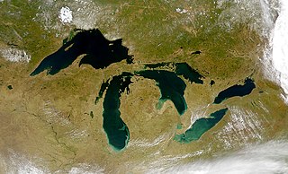
| వివరణ | Satellite image of the Great Lakes from space |
| తేదీ | |
| మూలం | http://visibleearth.nasa.gov/view_rec.php?id=793 |
| కర్త | SeaWiFS Project, NASA/Goddard Space Flight Center, and ORBIMAGE. |
| ఇతర కూర్పులు |
  |
లైసెన్సింగ్
| This image is from the Sea-viewing Wide Field-of-view Sensor (SeaWiFS) Project and more than 5 years old.
Satellite data captured by the SeaWIFS sensor are released into the public domain 5 years after capture. Data less than five years old can be re-used only for educational or scientific purposes; any commercial use of such images must be coordinated with GeoEye. [1] |
| This work has been released into the public domain' by its copyright holder, GeoEye. This applies worldwide. కొన్ని దేశాల్లో ఇది చట్టబద్ధంగా సాధ్యంకాకపోవచ్చు; అయితే: ఈ కృతిని ఎటువంటి షరతులు లేకుండా, అట్టి షరతులు చట్టం వల్ల తప్పనిసరి అయితే తప్ప, ఏ ఉద్దేశానికైనా ఉపయోగించుకునే హక్కును ఎవరికైనా GeoEye ప్రదానం చేస్తున్నారు.
|
ఫైలు చరితం
తేదీ/సమయం ను నొక్కి ఆ సమయాన ఫైలు ఎలా ఉండేదో చూడవచ్చు.
| తేదీ/సమయం | నఖచిత్రం | కొలతలు | వాడుకరి | వ్యాఖ్య | |
|---|---|---|---|---|---|
| ప్రస్తుత | 15:22, 22 సెప్టెంబరు 2010 | | 900 × 546 (147 KB) | Floydian | Reverted to version as of 03:45, 19 March 2005. Upload under a new filename, some pages depend on the former image showing the surroundings of the lakes (eg. Lake Nipigon) |
| 16:02, 6 సెప్టెంబరు 2010 |  | 5,200 × 4,000 (3.77 MB) | Anirudh Emani | High Resolution + Improved Image Quality | |
| 03:45, 19 మార్చి 2005 |  | 900 × 546 (147 KB) | Fanghong | from en wiki |
లింకులు
కింది పేజీలలో ఈ ఫైలుకు లింకులు ఉన్నాయి:
సార్వత్రిక ఫైలు వాడుక
ఈ దస్త్రాన్ని ఈ క్రింది ఇతర వికీలు ఉపయోగిస్తున్నాయి:
- af.wikipedia.org లో వాడుక
- als.wikipedia.org లో వాడుక
- an.wikipedia.org లో వాడుక
- arc.wikipedia.org లో వాడుక
- ar.wikipedia.org లో వాడుక
- arz.wikipedia.org లో వాడుక
- be-tarask.wikipedia.org లో వాడుక
- bg.wikipedia.org లో వాడుక
- br.wikipedia.org లో వాడుక
- ca.wikipedia.org లో వాడుక
- co.wikipedia.org లో వాడుక
- cs.wikipedia.org లో వాడుక
- da.wikipedia.org లో వాడుక
- de.wikipedia.org లో వాడుక
- en.wikipedia.org లో వాడుక
- en.wikibooks.org లో వాడుక
- eo.wikipedia.org లో వాడుక
- es.wikipedia.org లో వాడుక
- et.wikipedia.org లో వాడుక
- eu.wikipedia.org లో వాడుక
- fa.wikipedia.org లో వాడుక
ఈ దస్త్రపు మరింత సార్వత్రిక వాడుకను చూడండి.