దస్త్రం:Haiti deforestation.jpg
ఈ మునుజూపు పరిమాణం: 800 × 600 పిక్సెళ్ళు. ఇతర రిజల్యూషన్లు: 320 × 240 పిక్సెళ్ళు | 640 × 480 పిక్సెళ్ళు | 1,024 × 768 పిక్సెళ్ళు | 1,280 × 960 పిక్సెళ్ళు | 2,560 × 1,920 పిక్సెళ్ళు.
అసలు దస్త్రం (2,560 × 1,920 పిక్సెళ్ళు, ఫైలు పరిమాణం: 1.48 MB, MIME రకం: image/jpeg)
This is a file from the Wikimedia Commons. Information from its description page there is shown below. Commons is a freely licensed media file repository. You can help. |
| వివరణ |
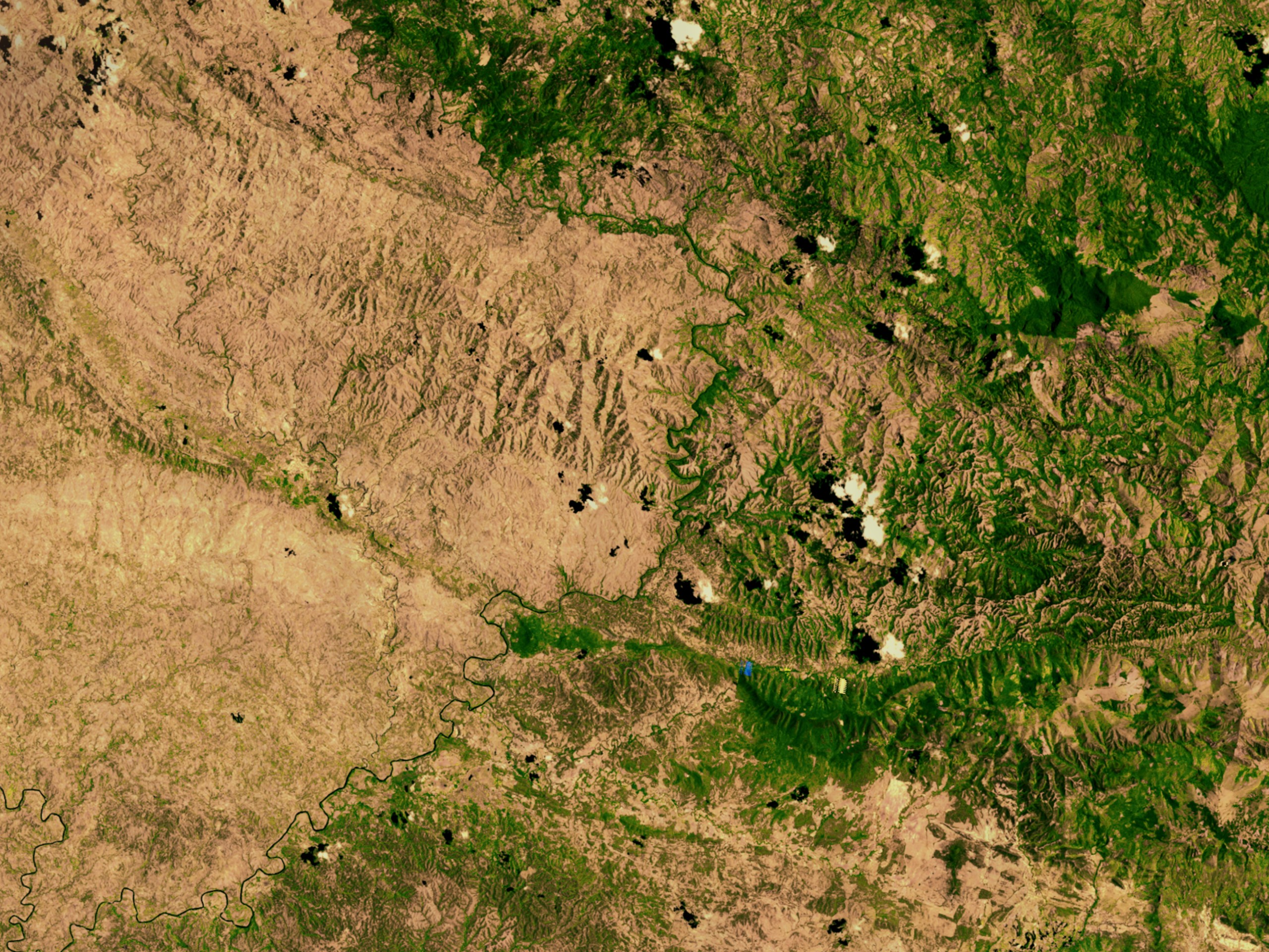
English: Satellite image showing deforestation in Haiti, Haiti-Centre. This image depicts the border between Haiti (left) and the Dominican Republic (right). |
|||||
| తేదీ | ||||||
| మూలం | http://svs.gsfc.nasa.gov/vis/a000000/a002600/a002640/ | |||||
| కర్త | NASA | |||||
| అనుమతి (ఈ దస్త్రాన్ని పునర్వినియోగించుకోవడం) |
|

| Object location | | View this and other nearby images on: OpenStreetMap |
|---|
ఫైలు చరితం
తేదీ/సమయం ను నొక్కి ఆ సమయాన ఫైలు ఎలా ఉండేదో చూడవచ్చు.
| తేదీ/సమయం | నఖచిత్రం | కొలతలు | వాడుకరి | వ్యాఖ్య | |
|---|---|---|---|---|---|
| ప్రస్తుత | 02:54, 10 మార్చి 2008 | | 2,560 × 1,920 (1.48 MB) | Calliopejen | {{Information |Description=Satellite image showing deforestation in Haiti. This image depicts the border between Haiti (left) and the Dominican Republic (right). |Source=http://svs.gsfc.nasa.gov/vis/a000000/a002600/a002640/ |Date=2002-09-25 |Author=NASA | |
లింకులు
కింది పేజీలలో ఈ ఫైలుకు లింకులు ఉన్నాయి:
సార్వత్రిక ఫైలు వాడుక
ఈ దస్త్రాన్ని ఈ క్రింది ఇతర వికీలు ఉపయోగిస్తున్నాయి:
- af.wikipedia.org లో వాడుక
- ar.wikipedia.org లో వాడుక
- ast.wikipedia.org లో వాడుక
- az.wikipedia.org లో వాడుక
- be.wikipedia.org లో వాడుక
- cs.wikipedia.org లో వాడుక
- de.wikipedia.org లో వాడుక
- de.wiktionary.org లో వాడుక
- en.wikipedia.org లో వాడుక
- en.wikinews.org లో వాడుక
- es.wikipedia.org లో వాడుక
- eu.wikipedia.org లో వాడుక
- fa.wikipedia.org లో వాడుక
- fr.wikipedia.org లో వాడుక
- fr.wikiversity.org లో వాడుక
- ht.wikipedia.org లో వాడుక
- ig.wikipedia.org లో వాడుక
- kk.wikipedia.org లో వాడుక
- la.wikipedia.org లో వాడుక
- mt.wikipedia.org లో వాడుక
- nn.wikipedia.org లో వాడుక
- no.wikipedia.org లో వాడుక
- oc.wikipedia.org లో వాడుక
- pa.wikipedia.org లో వాడుక
- pl.wikipedia.org లో వాడుక
- pt.wikipedia.org లో వాడుక
- pt.wikibooks.org లో వాడుక
- ru.wikipedia.org లో వాడుక
- uk.wikipedia.org లో వాడుక
ఈ దస్త్రపు మరింత సార్వత్రిక వాడుకను చూడండి.