దస్త్రం:IBCAO betamap.jpg
ఈ మునుజూపు పరిమాణం: 526 × 599 పిక్సెళ్ళు. ఇతర రిజల్యూషన్లు: 211 × 240 పిక్సెళ్ళు | 421 × 480 పిక్సెళ్ళు | 762 × 868 పిక్సెళ్ళు.
అసలు దస్త్రం (762 × 868 పిక్సెళ్ళు, ఫైలు పరిమాణం: 710 KB, MIME రకం: image/jpeg)
This is a file from the Wikimedia Commons. Information from its description page there is shown below. Commons is a freely licensed media file repository. You can help. |
| Description |
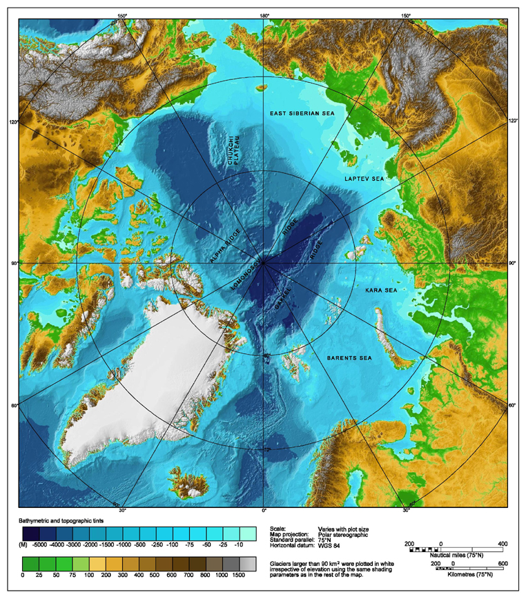
Bathymetric map of the Arctic Ocean |
|||||||||
| మూలం | http://www.ngdc.noaa.gov/mgg/image/IBCAO_betamap.jpg | |||||||||
| అనుమతి (ఈ దస్త్రాన్ని పునర్వినియోగించుకోవడం) |
|
|||||||||
| Geotemporal data | ||||||||||
| Bounding box |
|
|||||||||
| Georeferencing | ||||||||||
| ఇతర కూర్పులు |
Derivative works of this file: |
|||||||||
ఫైలు చరితం
తేదీ/సమయం ను నొక్కి ఆ సమయాన ఫైలు ఎలా ఉండేదో చూడవచ్చు.
| తేదీ/సమయం | నఖచిత్రం | కొలతలు | వాడుకరి | వ్యాఖ్య | |
|---|---|---|---|---|---|
| ప్రస్తుత | 00:29, 2 ఆగస్టు 2007 | | 762 × 868 (710 KB) | Mikkalai | Source: http://www.ngdc.noaa.gov/mgg/image/IBCAO_betamap.jpg Bathymetric map of the w:Arctic Ocean |
లింకులు
కింది పేజీలలో ఈ ఫైలుకు లింకులు ఉన్నాయి:
సార్వత్రిక ఫైలు వాడుక
ఈ దస్త్రాన్ని ఈ క్రింది ఇతర వికీలు ఉపయోగిస్తున్నాయి:
- af.wikipedia.org లో వాడుక
- ar.wikipedia.org లో వాడుక
- ary.wikipedia.org లో వాడుక
- ast.wikipedia.org లో వాడుక
- avk.wikipedia.org లో వాడుక
- azb.wikipedia.org లో వాడుక
- bcl.wikipedia.org లో వాడుక
- be.wikipedia.org లో వాడుక
- bg.wikipedia.org లో వాడుక
- bh.wikipedia.org లో వాడుక
- bn.wikipedia.org లో వాడుక
- bxr.wikipedia.org లో వాడుక
- ca.wikipedia.org లో వాడుక
- ceb.wikipedia.org లో వాడుక
- chr.wikipedia.org లో వాడుక
- co.wikipedia.org లో వాడుక
- crh.wikipedia.org లో వాడుక
- cs.wikipedia.org లో వాడుక
- da.wikipedia.org లో వాడుక
- de.wikipedia.org లో వాడుక
- dty.wikipedia.org లో వాడుక
- en.wikipedia.org లో వాడుక
- Talk:Lomonosov Ridge
- Territorial claims in the Arctic
- Arktika 2007
- Portal:Maps/Maps/Geographic
- Portal:Maps/Maps/Geographic/2
- Arctic Ocean
- User:Wiki User 68/My Portal/Selected geography/1
- List of Russian explorers
- Wikipedia:Reference desk/Archives/Science/2015 May 29
- User:Joelton Ivson/Gather lists/24441 – Conflitos internacionais
- en.wikinews.org లో వాడుక
- en.wikiversity.org లో వాడుక
- eo.wikipedia.org లో వాడుక
- es.wikipedia.org లో వాడుక
ఈ దస్త్రపు మరింత సార్వత్రిక వాడుకను చూడండి.