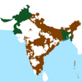
దస్త్రం:India and Pakistan 15 Aug 1947.png

ఈ మునుజూపు పరిమాణం: 602 × 599 పిక్సెళ్ళు. ఇతర రిజల్యూషన్లు: 241 × 240 పిక్సెళ్ళు | 482 × 480 పిక్సెళ్ళు | 771 × 768 పిక్సెళ్ళు | 1,028 × 1,024 పిక్సెళ్ళు | 1,432 × 1,426 పిక్సెళ్ళు.
అసలు దస్త్రం (1,432 × 1,426 పిక్సెళ్ళు, ఫైలు పరిమాణం: 42 KB, MIME రకం: image/png)
ఫైలు చరితం
తేదీ/సమయం ను నొక్కి ఆ సమయాన ఫైలు ఎలా ఉండేదో చూడవచ్చు.
| తేదీ/సమయం | నఖచిత్రం | కొలతలు | వాడుకరి | వ్యాఖ్య | |
|---|---|---|---|---|---|
| ప్రస్తుత | 12:08, 15 డిసెంబరు 2018 |  | 1,432 × 1,426 (42 KB) | Bodacius | {{Information |description ={{en|1=A map of the territorial extent of India and Pakistan ion immediately after Independence}} |date =15 December 2018 |source ={{own}} |author =User:Bodacius }} |
లింకులు
కింది పేజీలలో ఈ ఫైలుకు లింకులు ఉన్నాయి:
