దస్త్రం:Italy 1796 AD.png

ఈ మునుజూపు పరిమాణం: 419 × 600 పిక్సెళ్ళు. ఇతర రిజల్యూషన్లు: 167 × 240 పిక్సెళ్ళు | 335 × 480 పిక్సెళ్ళు | 1,007 × 1,442 పిక్సెళ్ళు.
అసలు దస్త్రం (1,007 × 1,442 పిక్సెళ్ళు, ఫైలు పరిమాణం: 92 KB, MIME రకం: image/png)
This is a file from the Wikimedia Commons. Information from its description page there is shown below. Commons is a freely licensed media file repository. You can help. |
సారాంశం
| వివరణ |
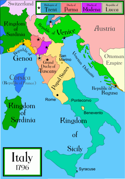
A political map of Italy in early 1796, before the Napoleonic wars, created by MapMaster.
|
||||||||
| మూలం | స్వంత కృతి | ||||||||
| కర్త | Capmo | ||||||||
| అనుమతి (ఈ దస్త్రాన్ని పునర్వినియోగించుకోవడం) |
నేను, ఈ కృతి యొక్క కాపీహక్కుదారుని, దీన్ని ఈ లైసెన్సు క్రింద ఇందుమూలముగా ప్రచురిస్తున్నాను:
|
||||||||
| ఇతర కూర్పులు |
[]
|


|
This historical map image could be re-created using vector graphics as an SVG file. This has several advantages; see Commons:Media for cleanup for more information. If an SVG form of this image is available, please upload it and afterwards replace this template with
{{vector version available|new image name}}.
It is recommended to name the SVG file “Italy 1796 AD.svg”—then the template Vector version available (or Vva) does not need the new image name parameter. |
ఫైలు చరితం
తేదీ/సమయం ను నొక్కి ఆ సమయాన ఫైలు ఎలా ఉండేదో చూడవచ్చు.
| తేదీ/సమయం | నఖచిత్రం | కొలతలు | వాడుకరి | వ్యాఖ్య | |
|---|---|---|---|---|---|
| ప్రస్తుత | 01:26, 21 ఏప్రిల్ 2009 | | 1,007 × 1,442 (92 KB) | Capmo | pallette reduction to 256 colours |
| 03:40, 16 ఏప్రిల్ 2007 |  | 1,007 × 1,442 (324 KB) | MapMaster | slightly improved | |
| 03:25, 22 నవంబరు 2006 |  | 629 × 901 (180 KB) | MapMaster | Slightly improved map: better color, location of capital cities, etc | |
| 04:29, 18 అక్టోబరు 2006 |  | 1,266 × 1,814 (418 KB) | MapMaster | I uploaded a slightly improved map | |
| 03:55, 17 అక్టోబరు 2006 |  | 1,267 × 1,821 (429 KB) | MapMaster | A political map of Italy in early 1796, before the Napoleonic wars, created by MapMaster. |
లింకులు
కింది పేజీలలో ఈ ఫైలుకు లింకులు ఉన్నాయి:
సార్వత్రిక ఫైలు వాడుక
ఈ దస్త్రాన్ని ఈ క్రింది ఇతర వికీలు ఉపయోగిస్తున్నాయి:
- ar.wikipedia.org లో వాడుక
- ast.wikipedia.org లో వాడుక
- azb.wikipedia.org లో వాడుక
- br.wikipedia.org లో వాడుక
- ca.wikipedia.org లో వాడుక
- cs.wikipedia.org లో వాడుక
- de.wikipedia.org లో వాడుక
- en.wikipedia.org లో వాడుక
- es.wikipedia.org లో వాడుక
- et.wikipedia.org లో వాడుక
- eu.wikipedia.org లో వాడుక
- fa.wikipedia.org లో వాడుక
- fi.wikipedia.org లో వాడుక
- fr.wikipedia.org లో వాడుక
- gl.wikipedia.org లో వాడుక
- he.wikipedia.org లో వాడుక
- hi.wikipedia.org లో వాడుక
- hr.wikipedia.org లో వాడుక
- hy.wikipedia.org లో వాడుక
- id.wikipedia.org లో వాడుక
- is.wikipedia.org లో వాడుక
- ja.wikipedia.org లో వాడుక
- ka.wikipedia.org లో వాడుక
- la.wikipedia.org లో వాడుక
- li.wikipedia.org లో వాడుక
ఈ దస్త్రపు మరింత సార్వత్రిక వాడుకను చూడండి.