దస్త్రం:Kashmir map big.jpg

ఈ మునుజూపు పరిమాణం: 522 × 600 పిక్సెళ్ళు. ఇతర రిజల్యూషన్లు: 209 × 240 పిక్సెళ్ళు | 418 × 480 పిక్సెళ్ళు | 668 × 768 పిక్సెళ్ళు | 891 × 1,024 పిక్సెళ్ళు | 1,951 × 2,242 పిక్సెళ్ళు.
అసలు దస్త్రం (1,951 × 2,242 పిక్సెళ్ళు, ఫైలు పరిమాణం: 2.32 MB, MIME రకం: image/jpeg)
This is a file from the Wikimedia Commons. Information from its description page there is shown below. Commons is a freely licensed media file repository. You can help. |
Pir gali shahdra Sharif
సారాంశం
| వివరణ |
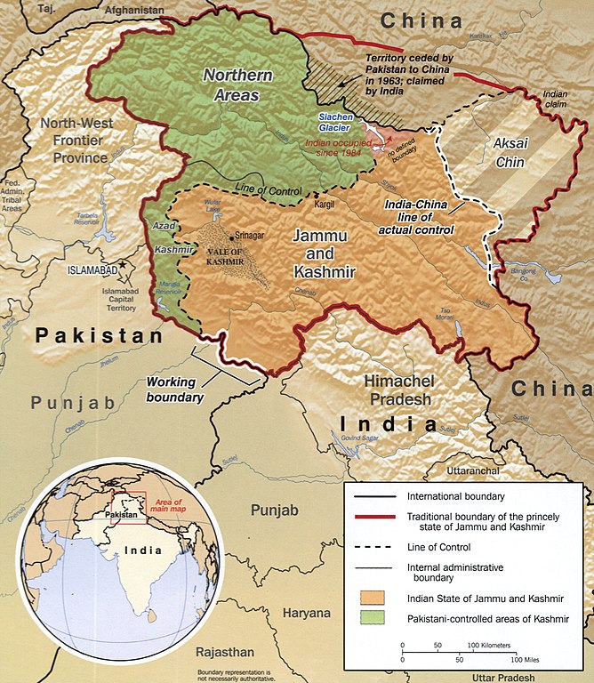
English: The disputed area of Kashmir.
|
||
| తేదీ | CREATED/PUBLISHED | ||
| మూలం |
|
||
| కర్త | Central Intelligence Agency, Washington, 2002 |

లైసెన్సింగ్
| This image is a work of a Central Intelligence Agency employee, taken or made as part of that person's official duties. As a Work of the United States Government, this image or media is in the public domain in the United States.
|

|
Old file history
taken from de.wiki there under PD with description
ఫైలు చరితం
తేదీ/సమయం ను నొక్కి ఆ సమయాన ఫైలు ఎలా ఉండేదో చూడవచ్చు.
| తేదీ/సమయం | నఖచిత్రం | కొలతలు | వాడుకరి | వ్యాఖ్య | |
|---|---|---|---|---|---|
| ప్రస్తుత | 17:04, 2 డిసెంబరు 2018 | | 1,951 × 2,242 (2.32 MB) | Ras67 | new cropped from LOC's high resolution TIFF |
| 22:23, 7 మార్చి 2006 |  | 985 × 1,131 (274 KB) | Sven-steffen arndt |
లింకులు
కింది పేజీలలో ఈ ఫైలుకు లింకులు ఉన్నాయి:
సార్వత్రిక ఫైలు వాడుక
ఈ దస్త్రాన్ని ఈ క్రింది ఇతర వికీలు ఉపయోగిస్తున్నాయి:
- ar.wikipedia.org లో వాడుక
- ast.wikipedia.org లో వాడుక
- as.wikipedia.org లో వాడుక
- azb.wikipedia.org లో వాడుక
- az.wikipedia.org లో వాడుక
- ba.wikipedia.org లో వాడుక
- be-tarask.wikipedia.org లో వాడుక
- be.wikipedia.org లో వాడుక
- bh.wikipedia.org లో వాడుక
- bn.wikipedia.org లో వాడుక
- ca.wikipedia.org లో వాడుక
- cs.wikipedia.org లో వాడుక
- diq.wikipedia.org లో వాడుక
- en.wikipedia.org లో వాడుక
- eo.wikipedia.org లో వాడుక
- es.wikipedia.org లో వాడుక
- Cachemira (región)
- Estado de Jammu y Cachemira
- Yihadismo
- Guerra sino-india
- Valle Shaksgam
- Conflicto de Cachemira
- Línea de control real
- Línea de control
- Insurgencia en Jammu y Cachemira
- Incidentes fronterizos entre India y Pakistán de 2013
- Frontera entre China y Pakistán
- Frontera entre Pakistán e India
- eu.wikipedia.org లో వాడుక
- fa.wikipedia.org లో వాడుక
ఈ దస్త్రపు మరింత సార్వత్రిక వాడుకను చూడండి.