దస్త్రం:Maps of Western Sahara.png
ఈ మునుజూపు పరిమాణం: 799 × 235 పిక్సెళ్ళు. ఇతర రిజల్యూషన్లు: 320 × 94 పిక్సెళ్ళు | 1,472 × 433 పిక్సెళ్ళు.
అసలు దస్త్రం (1,472 × 433 పిక్సెళ్ళు, ఫైలు పరిమాణం: 98 KB, MIME రకం: image/png)
This is a file from the Wikimedia Commons. Information from its description page there is shown below. Commons is a freely licensed media file repository. You can help. |

|
This map image could be re-created using vector graphics as an SVG file. This has several advantages; see Commons:Media for cleanup for more information. If an SVG form of this image is available, please upload it and afterwards replace this template with
{{vector version available|new image name}}.
It is recommended to name the SVG file “Maps of Western Sahara.svg”—then the template Vector version available (or Vva) does not need the new image name parameter. |
సారాంశం
| వివరణ |
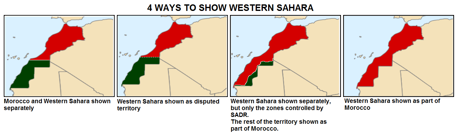
English: How Western Sahara is shown in maps |
| తేదీ | |
| మూలం |
This file was derived from: Sahrawi Arab Democratic Republic (orthographic projection) highlighted.svg: _highlighted.svg) |
| కర్త | Universalis |
లైసెన్సింగ్
నేను, ఈ కృతి యొక్క కాపీహక్కుదారుని, దీన్ని ఈ లైసెన్సు క్రింద ఇందుమూలముగా ప్రచురిస్తున్నాను:
This file is licensed under the Creative Commons Attribution-Share Alike 4.0 International license.
- ఇలా చేసేందుకు మీకు స్వేచ్ఛ ఉంది:
- పంచుకోడానికి – ఈ కృతిని కాపీ చేసుకోవచ్చు, పంపిణీ చేయవచ్చు, ప్రసారమూ చేయవచ్చు
- రీమిక్స్ చేయడానికి – కృతిని అనుకరించడానికి
- క్రింది షరతులకు లోబడి:
- ఆపాదింపు – సముచితమైన శ్రేయస్సును ఇవ్వాలి, లైసెన్సుకు లింకు ఇవ్వాలి, మార్పులేమైనా చేస్తే వాటిని సూచించాలి. అందుకు సముచితమైన పద్ధతి దేన్నైనా అవలంబించవచ్చు. కానీ మీకూ మీ వాడుకకూ హక్కుదారు అనుమతించారు అనే అర్థం వచ్చేటట్లుగా మాత్రం కాదు.
- share alike – మీరు ఈ కృతిని అనుకరిస్తే, మారిస్తే, లేదా మెరుగుపరిస్తే తత్ఫలిత కృతిని ఇదే లైసెన్సు లేదా దీనికి అనుగుణ్యమైన లైసెన్సు క్రింద మాత్రమే పంపిణీ చేయాలి.
ఫైలు చరితం
తేదీ/సమయం ను నొక్కి ఆ సమయాన ఫైలు ఎలా ఉండేదో చూడవచ్చు.
| తేదీ/సమయం | నఖచిత్రం | కొలతలు | వాడుకరి | వ్యాఖ్య | |
|---|---|---|---|---|---|
| ప్రస్తుత | 02:50, 25 డిసెంబరు 2020 | 1,472 × 433 (98 KB) | EdDakhla | More detailed version based of Locator Map (https://commons.wikimedia.org/wiki/File:LocationMorocco.svg) and de-facto map based on https://commons.wikimedia.org/wiki/File:Western_Sahara_conflict_map.svg | |
| 18:03, 1 జూన్ 2016 | 1,472 × 433 (36 KB) | Universalis | Better version | ||
| 18:10, 28 అక్టోబరు 2015 | 1,472 × 433 (37 KB) | Universalis | User created page with UploadWizard |
లింకులు
కింది పేజీలలో ఈ ఫైలుకు లింకులు ఉన్నాయి:
సార్వత్రిక ఫైలు వాడుక
ఈ దస్త్రాన్ని ఈ క్రింది ఇతర వికీలు ఉపయోగిస్తున్నాయి:
- ar.wikipedia.org లో వాడుక
- eu.wikipedia.org లో వాడుక
- fa.wikipedia.org లో వాడుక
- it.wikivoyage.org లో వాడుక
- pnb.wikipedia.org లో వాడుక
- ur.wikipedia.org లో వాడుక