దస్త్రం:Mexico's Territorial Evolution.png

ఈ మునుజూపు పరిమాణం: 659 × 599 పిక్సెళ్ళు. ఇతర రిజల్యూషన్లు: 264 × 240 పిక్సెళ్ళు | 528 × 480 పిక్సెళ్ళు | 844 × 768 పిక్సెళ్ళు | 1,126 × 1,024 పిక్సెళ్ళు | 1,669 × 1,518 పిక్సెళ్ళు.
అసలు దస్త్రం (1,669 × 1,518 పిక్సెళ్ళు, ఫైలు పరిమాణం: 113 KB, MIME రకం: image/png)
This is a file from the Wikimedia Commons. Information from its description page there is shown below. Commons is a freely licensed media file repository. You can help. |
సారాంశం

| వివరణ |
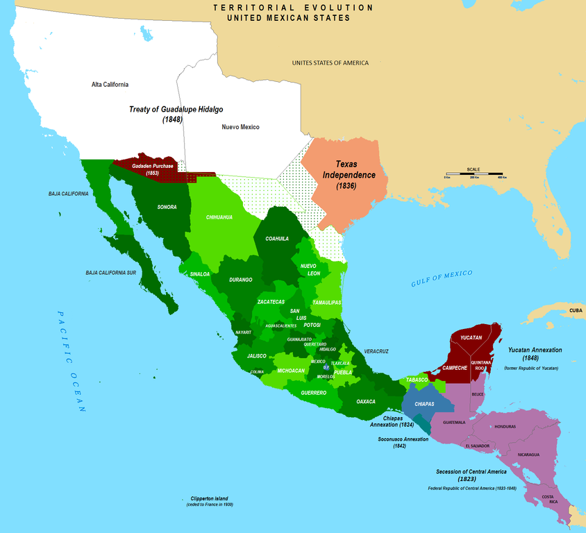
English: Territorial Evolution of Mexico since 1821 to 2009 |
| తేదీ | |
| మూలం | స్వంత కృతి |
| కర్త | Hpav7 |

|
This historical map image could be re-created using vector graphics as an SVG file. This has several advantages; see Commons:Media for cleanup for more information. If an SVG form of this image is available, please upload it and afterwards replace this template with
{{vector version available|new image name}}.
It is recommended to name the SVG file “Mexico's Territorial Evolution.svg”—then the template Vector version available (or Vva) does not need the new image name parameter. |
లైసెన్సింగ్
| నేను, ఈ కృతి యొక్క కాపీహక్కుదారుని, ఈ కృతిని సార్వజనీనం'గా విడుదల చేస్తున్నాను. ఇది ప్రపంచవ్యాప్తంగా వర్తిస్తుంది. కొన్ని దేశాల్లో ఇది చట్టబద్ధంగా సాధ్యంకాకపోవచ్చు; అయితే: ఈ కృతిని ఎటువంటి షరతులు లేకుండా, అట్టి షరతులు చట్టం వల్ల తప్పనిసరి అయితే తప్ప, ఏ ఉద్దేశానికైనా ఉపయోగించుకునే హక్కును ఎవరికైనా నేను ప్రదానం చేస్తున్నాను. |
ఫైలు చరితం
తేదీ/సమయం ను నొక్కి ఆ సమయాన ఫైలు ఎలా ఉండేదో చూడవచ్చు.
| తేదీ/సమయం | నఖచిత్రం | కొలతలు | వాడుకరి | వ్యాఖ్య | |
|---|---|---|---|---|---|
| ప్రస్తుత | 23:09, 14 సెప్టెంబరు 2019 | | 1,669 × 1,518 (113 KB) | Urbanuntil | checking that is software error |
| 23:01, 14 సెప్టెంబరు 2019 |  | 1,669 × 1,518 (132 KB) | Urbanuntil | - | |
| 22:54, 14 సెప్టెంబరు 2019 |  | 1,669 × 1,518 (145 KB) | Urbanuntil | checking color mistake's origin | |
| 22:46, 14 సెప్టెంబరు 2019 |  | 1,669 × 1,518 (132 KB) | Urbanuntil | grammar | |
| 03:47, 3 ఏప్రిల్ 2010 |  | 1,669 × 1,518 (147 KB) | Hpav7 | Various | |
| 10:54, 4 డిసెంబరు 2009 |  | 1,669 × 1,518 (147 KB) | Hpav7 | correccion de los margenes y limites fronterizos correction of the margins and border boundaries | |
| 03:29, 19 జూలై 2009 |  | 1,669 × 1,518 (147 KB) | Hpav7 | {{Information |Description={{en|1=Territorial Evolution of Mexico since 1821 to 2009}} |Source=Own work by uploader |Author=Hpav7 |Date=2009-07-18 |Permission= |other_versions= }} Category:Maps of Mexico Category:Map of Mexico [[Ca |
లింకులు
కింది పేజీలలో ఈ ఫైలుకు లింకులు ఉన్నాయి:
సార్వత్రిక ఫైలు వాడుక
ఈ దస్త్రాన్ని ఈ క్రింది ఇతర వికీలు ఉపయోగిస్తున్నాయి:
- af.wikipedia.org లో వాడుక
- ar.wikipedia.org లో వాడుక
- arz.wikipedia.org లో వాడుక
- be.wikipedia.org లో వాడుక
- cs.wikipedia.org లో వాడుక
- de.wikipedia.org లో వాడుక
- en.wikipedia.org లో వాడుక
- es.wikipedia.org లో వాడుక
- eu.wikipedia.org లో వాడుక
- fr.wikipedia.org లో వాడుక
- ia.wikipedia.org లో వాడుక
- la.wikipedia.org లో వాడుక
- mk.wikipedia.org లో వాడుక
- pl.wikipedia.org లో వాడుక
- pt.wikipedia.org లో వాడుక
- sh.wikipedia.org లో వాడుక
- sr.wikipedia.org లో వాడుక
- sw.wikipedia.org లో వాడుక
- www.wikidata.org లో వాడుక