దస్త్రం:Muromian-map.png

ఈ మునుజూపు పరిమాణం: 588 × 600 పిక్సెళ్ళు. ఇతర రిజల్యూషన్లు: 235 × 240 పిక్సెళ్ళు | 610 × 622 పిక్సెళ్ళు.
అసలు దస్త్రం (610 × 622 పిక్సెళ్ళు, ఫైలు పరిమాణం: 165 KB, MIME రకం: image/png)
This is a file from the Wikimedia Commons. Information from its description page there is shown below. Commons is a freely licensed media file repository. You can help. |

|
File:Finno-ugrian-map.svg is a vector version of this file. It should be used in place of this PNG file when not inferior.
File:Muromian-map.png → File:Finno-ugrian-map.svg
For more information, see Help:SVG. |
 |
సారాంశం
| వివరణ |
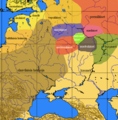
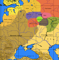
English: An approximate ethno-linguistic map of Kievan Rus' in the 9th century: Five Volga Finnic groups of the Merya, Mari, Muromians, Meshchera and Mordvins are shown as surrounded by the Slavs to the west; the three Finnic groups of the Veps, Ests and Chuds, and Indo-European Balts to the northwest; the Permians to the northeast the (Turkic) Bulghars and Khazars to the southeast and south. |
| మూలం | File:Finno-ugrian-map.svg states that it is based on Рябинин Е. А. Финно-угорские племена в составе Древней Руси. |
| కర్త | Wiglaf. |
లైసెన్సింగ్

|
ఈ కృతి యొక్క కర్తనైన నేను, ఇక నుండీ ఈ కృతిని కాపీ చేసుకోవడానికి, పంచి పెట్టడానికి మరియు/లేదా మార్పులు-చేర్పులు చేసుకోవడానికి GFDL, లైసెన్సు వెర్షను 1.2 లేదా దాని తరువాత స్వేచ్చా సాఫ్టువేరు ఫౌండేషను విడుదలచేసే ఏ GFDL లైసెన్సు ద్వారా నయినా అనుమతి ఇస్తున్నాను; ఈ కృతిలో మార్చకూడని బాగాలు లేవు, Front-Cover పాఠం లేదు, Back-Cover పాఠం లేదు. ఈ లైసెన్సు యొక్క పత్రం నకలును "జిఎన్యూ ఉచిత డాక్యుమెంటేషను లైసెన్సు" అని పిలుస్తున్న విభాగంలో ఉంది. |
| ఈ దస్త్రం క్రియేటివ్ కామన్స్ Attribution-Share Alike 3.0 Unported లైసెన్సు క్రింద లభ్యం. | ||
| ||
| GFDL లైసెన్సు తాజాకరణలో భాగంగా ఈ దస్త్రానికి ఈ లైసెన్సింగు ట్యాగుని చేర్చారు. |
Other versions
-
 Español
 -
 Italiano
 -
 suomi
suomi


ఫైలు చరితం
తేదీ/సమయం ను నొక్కి ఆ సమయాన ఫైలు ఎలా ఉండేదో చూడవచ్చు.
| తేదీ/సమయం | నఖచిత్రం | కొలతలు | వాడుకరి | వ్యాఖ్య | |
|---|---|---|---|---|---|
| ప్రస్తుత | 13:47, 9 అక్టోబరు 2016 | | 610 × 622 (165 KB) | Julieta39 | No Soviet dam reservoirs 1000 years ago, and differentiation between "Danube-" and "Volga-" Bulgars |
| 00:07, 9 మార్చి 2013 |  | 610 × 622 (164 KB) | Martintg | Located Chudes based upon academic sources | |
| 23:10, 10 డిసెంబరు 2007 |  | 610 × 622 (144 KB) | Incnis Mrsi | There was no such thing as w:en:Rybinsk Reservoir before "Slavonic tribes" came ☺ | |
| 11:01, 6 అక్టోబరు 2006 |  | 610 × 622 (113 KB) | Mets501 | fix tribe name (vepses --> veps) | |
| 13:07, 7 డిసెంబరు 2005 |  | 610 × 622 (145 KB) | Joonasl | From en-wiki by [http://en.wikipedia.org/wiki/User:Wiglaf Wiglaf]. Category:Uralic languages {{GFDL}} |
లింకులు
కింది పేజీలలో ఈ ఫైలుకు లింకులు ఉన్నాయి:
సార్వత్రిక ఫైలు వాడుక
ఈ దస్త్రాన్ని ఈ క్రింది ఇతర వికీలు ఉపయోగిస్తున్నాయి:
- af.wikipedia.org లో వాడుక
- ang.wikipedia.org లో వాడుక
- be-tarask.wikipedia.org లో వాడుక
- be.wikipedia.org లో వాడుక
- bg.wikipedia.org లో వాడుక
- br.wikipedia.org లో వాడుక
- ca.wikipedia.org లో వాడుక
- cs.wikipedia.org లో వాడుక
- cv.wikipedia.org లో వాడుక
- da.wikipedia.org లో వాడుక
- da.wikibooks.org లో వాడుక
- el.wikipedia.org లో వాడుక
- en.wikipedia.org లో వాడుక
- eo.wikipedia.org లో వాడుక
- es.wikipedia.org లో వాడుక
- et.wikipedia.org లో వాడుక
- eu.wikipedia.org లో వాడుక
ఈ దస్త్రపు మరింత సార్వత్రిక వాడుకను చూడండి.