దస్త్రం:Ocean gravity map.gif
ఈ మునుజూపు పరిమాణం: 800 × 473 పిక్సెళ్ళు. ఇతర రిజల్యూషన్లు: 320 × 189 పిక్సెళ్ళు | 640 × 378 పిక్సెళ్ళు | 1,010 × 597 పిక్సెళ్ళు.
అసలు దస్త్రం (1,010 × 597 పిక్సెళ్ళు, ఫైలు పరిమాణం: 466 KB, MIME రకం: image/gif)
This is a file from the Wikimedia Commons. Information from its description page there is shown below. Commons is a freely licensed media file repository. You can help. |
| వివరణ |
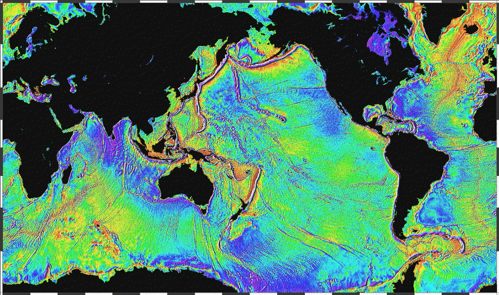
English: Ocean basins mapped with satellite altimetry. Seafloor features larger than 10 km are detected by resulting gravitational distortion of sea surface. |
| తేదీ | |
| మూలం | http://www.ngdc.noaa.gov/mgg/bathymetry/predicted/explore.HTML |
| కర్త | NOAA |
This image is in the public domain because it contains materials that originally came from the U.S. National Oceanic and Atmospheric Administration, taken or made as part of an employee's official duties.
|
ఫైలు చరితం
తేదీ/సమయం ను నొక్కి ఆ సమయాన ఫైలు ఎలా ఉండేదో చూడవచ్చు.
| తేదీ/సమయం | నఖచిత్రం | కొలతలు | వాడుకరి | వ్యాఖ్య | |
|---|---|---|---|---|---|
| ప్రస్తుత | 22:18, 3 ఏప్రిల్ 2006 | | 1,010 × 597 (466 KB) | Korrigan | Ocean basins mapped with satellite altimetry. Seafloor features larger than 10 km are detected by resulting gravitational distortion of sea surface. Source: http://www.ngdc.noaa.gov/mgg/bathymetry/predicted/explore.HTML {{PD-USGov-DOC-NOAA}} [[Cate |
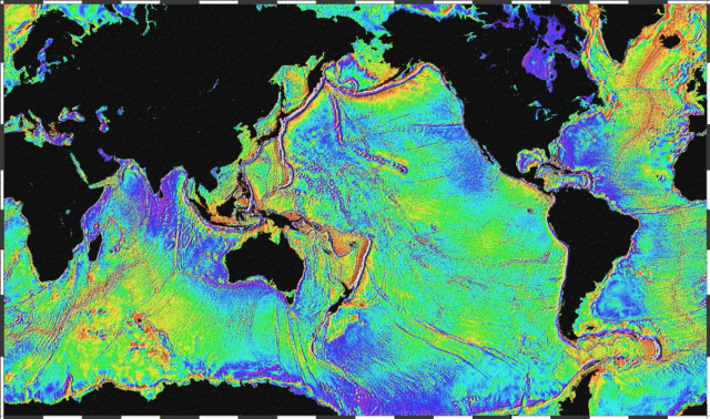
| 20:36, 19 మార్చి 2006 |  | 1,010 × 597 (196 KB) | Maksim | La bildo estas kopiita de wikipedia:en. La originala priskribo estas: Ocean basins mapped with satellite altimetry. Seafloor features larger than 10 km are detected by resulting gravitational distortion of sea surface. Source: http://www.ngdc.noaa.go |
లింకులు
కింది పేజీలలో ఈ ఫైలుకు లింకులు ఉన్నాయి:
సార్వత్రిక ఫైలు వాడుక
ఈ దస్త్రాన్ని ఈ క్రింది ఇతర వికీలు ఉపయోగిస్తున్నాయి:
- bs.wikipedia.org లో వాడుక
- bxr.wikipedia.org లో వాడుక
- cs.wikipedia.org లో వాడుక
- de.wikipedia.org లో వాడుక
- el.wikipedia.org లో వాడుక
- en.wikipedia.org లో వాడుక
- eo.wikipedia.org లో వాడుక
- es.wikipedia.org లో వాడుక
- et.wikipedia.org లో వాడుక
- fi.wikipedia.org లో వాడుక
- fo.wikipedia.org లో వాడుక
- fr.wikipedia.org లో వాడుక
- fr.wiktionary.org లో వాడుక
- gd.wikipedia.org లో వాడుక
- gl.wikipedia.org లో వాడుక
- gu.wikipedia.org లో వాడుక
- he.wikipedia.org లో వాడుక
- hi.wikipedia.org లో వాడుక
- hr.wikipedia.org లో వాడుక
- ht.wikipedia.org లో వాడుక
- hy.wikipedia.org లో వాడుక
- hyw.wikipedia.org లో వాడుక
- ja.wikipedia.org లో వాడుక
- kk.wikipedia.org లో వాడుక
- la.wikipedia.org లో వాడుక
- lv.wikipedia.org లో వాడుక
- mn.wikipedia.org లో వాడుక
- ru.wikipedia.org లో వాడుక
- scn.wikipedia.org లో వాడుక
- sh.wikipedia.org లో వాడుక
- sl.wikipedia.org లో వాడుక
- sv.wikipedia.org లో వాడుక
- ta.wikipedia.org లో వాడుక
ఈ దస్త్రపు మరింత సార్వత్రిక వాడుకను చూడండి.