దస్త్రం:OceaniaLocation.svg

ఈ ఫైలు SVG కు చెందిన ఈ మునుజూపు PNG పరిమాణం: 463 × 236 పిక్సెళ్ళు. ఇతర రిజల్యూషన్లు: 320 × 163 పిక్సెళ్ళు | 640 × 326 పిక్సెళ్ళు | 1,024 × 522 పిక్సెళ్ళు | 1,280 × 652 పిక్సెళ్ళు | 2,560 × 1,305 పిక్సెళ్ళు.
అసలు దస్త్రం (SVG ఫైలు, నామమాత్రంగా 463 × 236 పిక్సెళ్ళు, ఫైలు పరిమాణం: 290 KB)
This is a file from the Wikimedia Commons. Information from its description page there is shown below. Commons is a freely licensed media file repository. You can help. |
సారాంశం
| వివరణ |
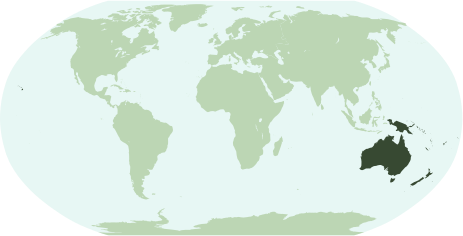
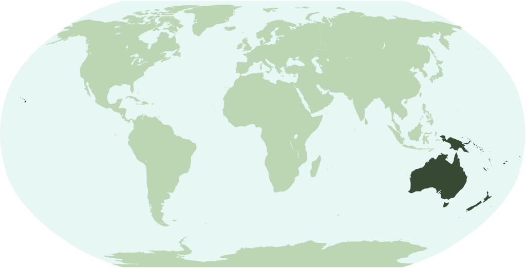
English: Map showing the location of the region/continent of Oceania (including all pacific islands and Hawaii).
Français : Une carte pour démontrer la location de la région (continent) d'Oceanie (avec tous les îles pacifiques et Hawaï).
Interlingua: Un Mapa monstrante le location del region/continente de Oceania (includinte omne insulas pacific e Hawai). |
| తేదీ | |
| మూలం | స్వంత కృతి |
| కర్త | Notscott |
లైసెన్సింగ్
| నేను, ఈ కృతి యొక్క కాపీహక్కుదారుని, ఈ కృతిని సార్వజనీనం'గా విడుదల చేస్తున్నాను. ఇది ప్రపంచవ్యాప్తంగా వర్తిస్తుంది. కొన్ని దేశాల్లో ఇది చట్టబద్ధంగా సాధ్యంకాకపోవచ్చు; అయితే: ఈ కృతిని ఎటువంటి షరతులు లేకుండా, అట్టి షరతులు చట్టం వల్ల తప్పనిసరి అయితే తప్ప, ఏ ఉద్దేశానికైనా ఉపయోగించుకునే హక్కును ఎవరికైనా నేను ప్రదానం చేస్తున్నాను. |
ఫైలు చరితం
తేదీ/సమయం ను నొక్కి ఆ సమయాన ఫైలు ఎలా ఉండేదో చూడవచ్చు.
| తేదీ/సమయం | నఖచిత్రం | కొలతలు | వాడుకరి | వ్యాఖ్య | |
|---|---|---|---|---|---|
| ప్రస్తుత | 23:26, 14 జనవరి 2007 | | 463 × 236 (290 KB) | Notscott | {{en}} Map showing the location of the region/continent of Oceania (including all pacific islands and Hawaii). {{ia}} Mapa monstrante le location del region/continente de Oceania (includinte omne insulas pacific e Hawai). {{fr}} Carte pour démontrer la l |
లింకులు
కింది పేజీలలో ఈ ఫైలుకు లింకులు ఉన్నాయి:
సార్వత్రిక ఫైలు వాడుక
ఈ దస్త్రాన్ని ఈ క్రింది ఇతర వికీలు ఉపయోగిస్తున్నాయి:
- ace.wikipedia.org లో వాడుక
- arz.wikipedia.org లో వాడుక
- avk.wikipedia.org లో వాడుక
- az.wikipedia.org లో వాడుక
- Papua-Yeni Qvineya
- Yeni Zelandiya
- Kiribati
- Amerika Samoası
- Quam
- Şimali Marian adaları
- Tokelau
- Kokos adaları
- Vanuatu
- Nauru
- Fici
- Yeni Kaledoniya
- Taiti
- Mikroneziya
- Marşall adaları
- Palau
- Avstraliya
- Tuvalu
- Kuk adaları
- Milad adası
- Niue
- Norfolk adası
- Pitkern adaları
- Samoa
- Solomon adaları
- Tonqa
- Uollis və Futuna
- Şablon:Okeaniya
- Avstraliya dolları
- bm.wikipedia.org లో వాడుక
- bpy.wikipedia.org లో వాడుక
- cbk-zam.wikipedia.org లో వాడుక
- en.wikipedia.org లో వాడుక
ఈ దస్త్రపు మరింత సార్వత్రిక వాడుకను చూడండి.