దస్త్రం:Outre-mer en sans Terre Adelie.png
ఈ మునుజూపు పరిమాణం: 800 × 342 పిక్సెళ్ళు. ఇతర రిజల్యూషన్లు: 320 × 137 పిక్సెళ్ళు | 640 × 273 పిక్సెళ్ళు | 1,456 × 622 పిక్సెళ్ళు.
అసలు దస్త్రం (1,456 × 622 పిక్సెళ్ళు, ఫైలు పరిమాణం: 49 KB, MIME రకం: image/png)
This is a file from the Wikimedia Commons. Information from its description page there is shown below. Commons is a freely licensed media file repository. You can help. |
సారాంశం

|
This locator map image could be re-created using vector graphics as an SVG file. This has several advantages; see Commons:Media for cleanup for more information. If an SVG form of this image is available, please upload it and afterwards replace this template with
{{vector version available|new image name}}.
It is recommended to name the SVG file “Outre-mer en sans Terre Adelie.svg”—then the template Vector version available (or Vva) does not need the new image name parameter. |
| వివరణ |
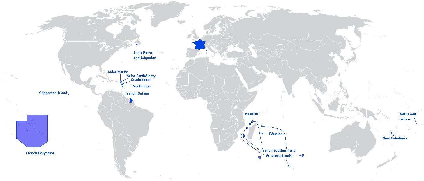
English: A map showing the Overseas departments and territories of France, excluding the territory of Adélie Land in Antarctica, where sovereignty is suspended |
| తేదీ | |
| మూలం | స్వంత కృతి |
| కర్త | Originally Hoshie |
| ఇతర కూర్పులు | Adapted from File:Outre-mer en.png |
English: This image is a cropped version of Image:Outre-mer en.png initally created by user Hoshie. Antarctica was cropped.
లైసెన్సింగ్
Hoshie, ఈ కృతి యొక్క కాపీహక్కుదారు, దీన్ని ఇందుమూలముగా ఈ లైసెన్సు క్రింద ప్రచురిస్తున్నారు:

|
ఈ కృతి యొక్క కర్తనైన నేను, ఇక నుండీ ఈ కృతిని కాపీ చేసుకోవడానికి, పంచి పెట్టడానికి మరియు/లేదా మార్పులు-చేర్పులు చేసుకోవడానికి GFDL, లైసెన్సు వెర్షను 1.2 లేదా దాని తరువాత స్వేచ్చా సాఫ్టువేరు ఫౌండేషను విడుదలచేసే ఏ GFDL లైసెన్సు ద్వారా నయినా అనుమతి ఇస్తున్నాను; ఈ కృతిలో మార్చకూడని బాగాలు లేవు, Front-Cover పాఠం లేదు, Back-Cover పాఠం లేదు. ఈ లైసెన్సు యొక్క పత్రం నకలును "జిఎన్యూ ఉచిత డాక్యుమెంటేషను లైసెన్సు" అని పిలుస్తున్న విభాగంలో ఉంది. |
| ఈ దస్త్రం క్రియేటివ్ కామన్స్ Attribution-Share Alike 3.0 Unported లైసెన్సు క్రింద లభ్యం. | ||
| ఆపాదింపు: Hoshie | ||
| ||
| GFDL లైసెన్సు తాజాకరణలో భాగంగా ఈ దస్త్రానికి ఈ లైసెన్సింగు ట్యాగుని చేర్చారు. |
ఫైలు చరితం
తేదీ/సమయం ను నొక్కి ఆ సమయాన ఫైలు ఎలా ఉండేదో చూడవచ్చు.
| తేదీ/సమయం | నఖచిత్రం | కొలతలు | వాడుకరి | వ్యాఖ్య | |
|---|---|---|---|---|---|
| ప్రస్తుత | 20:26, 27 మార్చి 2018 | | 1,456 × 622 (49 KB) | Maphobbyist | Upload |
| 12:01, 27 మే 2012 |  | 1,456 × 622 (59 KB) | Hazhk | Changing color | |
| 20:47, 12 ఫిబ్రవరి 2012 |  | 1,480 × 625 (68 KB) | Spesh531 | same as File:Outre-mer en.png, without Antarctica | |
| 00:35, 21 అక్టోబరు 2010 |  | 1,431 × 655 (54 KB) | Rosss | Better view of French Polynesia | |
| 21:23, 25 నవంబరు 2009 |  | 1,431 × 655 (30 KB) | The Illusional Ministry | removed borer from french polynesia | |
| 21:22, 25 నవంబరు 2009 |  | 1,431 × 655 (30 KB) | The Illusional Ministry | ||
| 03:31, 17 డిసెంబరు 2007 |  | 1,431 × 655 (35 KB) | Rosss | Wider margin | |
| 03:26, 17 డిసెంబరు 2007 |  | 1,431 × 639 (35 KB) | Rosss | This image is a cropped version of Image:Outre-mer en.png initally created by user Hoshie. Antartica was cropped. ==License== {{GFDL-user|Hoshie}} Category:World maps of Overseas France |
లింకులు
కింది పేజీలలో ఈ ఫైలుకు లింకులు ఉన్నాయి:
సార్వత్రిక ఫైలు వాడుక
ఈ దస్త్రాన్ని ఈ క్రింది ఇతర వికీలు ఉపయోగిస్తున్నాయి:
- an.wikipedia.org లో వాడుక
- awa.wikipedia.org లో వాడుక
- bn.wikibooks.org లో వాడుక
- ckb.wikipedia.org లో వాడుక
- da.wikipedia.org లో వాడుక
- dv.wikipedia.org లో వాడుక
- en.wikipedia.org లో వాడుక
- Regions of France
- Outline of France
- Wikipedia:Graphics Lab/Map workshop/Archive/Dec 2009
- Wikipedia:Graphics Lab/Map workshop/Archive/Jun 2012
- User:SkulkingMEDIA
- User:Andreapr94/sandbox/Infobox/Country
- User:Jonperez91/sandbox/Infoboxes/Country
- User:Ane San José/sandbox/Infobox/Country
- User:P.aurrecoechea/Sandbox/Infobox/Country
- User:Trizia9/sandbox/Infobox/Country
- User:Ibonarzua/sandbox/Infobox/Country
- User:Mikel M/sandbox/Infobox/Country
- en.wikibooks.org లో వాడుక
- es.wikipedia.org లో వాడుక
- et.wikipedia.org లో వాడుక
- eu.wikipedia.org లో వాడుక
- fa.wikipedia.org లో వాడుక
- fr.wikipedia.org లో వాడుక
- hi.wikipedia.org లో వాడుక
- hy.wikipedia.org లో వాడుక
- id.wikipedia.org లో వాడుక
- id.wikibooks.org లో వాడుక
- ilo.wikipedia.org లో వాడుక
- ja.wikipedia.org లో వాడుక
- lv.wikipedia.org లో వాడుక
- mai.wikipedia.org లో వాడుక
- min.wikipedia.org లో వాడుక
- ml.wikipedia.org లో వాడుక
- mzn.wikipedia.org లో వాడుక
- ne.wikipedia.org లో వాడుక
- nl.wikipedia.org లో వాడుక
- no.wikipedia.org లో వాడుక
- pa.wikipedia.org లో వాడుక
- pcd.wikipedia.org లో వాడుక
- pdc.wikipedia.org లో వాడుక
- pt.wikipedia.org లో వాడుక
- sah.wikipedia.org లో వాడుక
- sh.wikipedia.org లో వాడుక
ఈ దస్త్రపు మరింత సార్వత్రిక వాడుకను చూడండి.