దస్త్రం:PhoenicianTrade.png
మరింత స్పష్టమైన బొమ్మ లేదు.
PhoenicianTrade.png (558 × 418 పిక్సెళ్ళు, ఫైలు పరిమాణం: 204 KB, MIME రకం: image/png)
This is a file from the Wikimedia Commons. Information from its description page there is shown below. Commons is a freely licensed media file repository. You can help. |

|
File:PhoenicianTrade EN.svg is a vector version of this file. It should be used in place of this PNG file when not inferior.
File:PhoenicianTrade.png → File:PhoenicianTrade EN.svg
For more information, see Help:SVG. |
 |
| This is a retouched picture, which means that it has been digitally altered from its original version. Modifications: changed legend to English. Modifications made by Yom. The original can be found here: //ar.wikipedia.org/wiki/ملف:Ph_routes.jpg.
|
సారాంశం
| వివరణ |
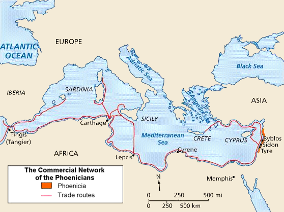
English: Phoenician trade routes. The cities in North Africa and Southern Europe represent the extent of the Phoenician sphere of influence, from their base in North Palestine.
العربية: خريطة طرق التجارة الفينيقية في البحر المتوسط والتي تبدأ من مركز الفينيقيين في المدن الساحلية اللبنانية جبيل وصيدا وصور وشمال فلسطين وتمر عبر قرطاج لتصل جزيرة سردينيا. هذا النطاق الواسع من المدن الذي تمر عبره تجارة الفينيقيين في شمال إفريقيا وجنوب أوروبا يظهر مدى نفوذ الفينيقيين الممتد من مركزهم في شمال فلسطين. وقد انتشرت الحضارة الفينيقية عبر البحر المتوسط بين 1500 ق.م و300 ق.م. |
| మూలం |
|
| కర్త | Yom (చర్చ · రచనలు) |
| ఇతర కూర్పులు |
[] SVG version 1
SVG version 2
|


.svg)


.svg)


లైసెన్సింగ్
నేను, ఈ కృతి యొక్క కాపీహక్కుదారుని, దీన్ని ఈ లైసెన్సు క్రింద ఇందుమూలముగా ప్రచురిస్తున్నాను:

|
ఈ కృతి యొక్క కర్తనైన నేను, ఇక నుండీ ఈ కృతిని కాపీ చేసుకోవడానికి, పంచి పెట్టడానికి మరియు/లేదా మార్పులు-చేర్పులు చేసుకోవడానికి GFDL, లైసెన్సు వెర్షను 1.2 లేదా దాని తరువాత స్వేచ్చా సాఫ్టువేరు ఫౌండేషను విడుదలచేసే ఏ GFDL లైసెన్సు ద్వారా నయినా అనుమతి ఇస్తున్నాను; ఈ కృతిలో మార్చకూడని బాగాలు లేవు, Front-Cover పాఠం లేదు, Back-Cover పాఠం లేదు. ఈ లైసెన్సు యొక్క పత్రం నకలును "జిఎన్యూ ఉచిత డాక్యుమెంటేషను లైసెన్సు" అని పిలుస్తున్న విభాగంలో ఉంది. |
| ఈ దస్త్రం క్రియేటివ్ కామన్స్ Attribution-Share Alike 3.0 Unported లైసెన్సు క్రింద లభ్యం. | ||
| ||
| GFDL లైసెన్సు తాజాకరణలో భాగంగా ఈ దస్త్రానికి ఈ లైసెన్సింగు ట్యాగుని చేర్చారు. |
అసలు ఎక్కింపుల చిట్టా
The original description page was here. All following user names refer to en.wikipedia.
- 2006-07-11 07:02 Yom 560×420 (269541 byte) Adapted by [[:en:User:Yom]] from [http://ar.wikipedia.org/wiki/%D8%B5%D9%88%D8%B1%D8%A9:Ph_routes.jpg Arabic version] (changed legend to English).
ఫైలు చరితం
తేదీ/సమయం ను నొక్కి ఆ సమయాన ఫైలు ఎలా ఉండేదో చూడవచ్చు.
| తేదీ/సమయం | నఖచిత్రం | కొలతలు | వాడుకరి | వ్యాఖ్య | |
|---|---|---|---|---|---|
| ప్రస్తుత | 01:56, 23 మార్చి 2010 | | 558 × 418 (204 KB) | Ras67 | cropped |
| 00:41, 21 ఆగస్టు 2006 |  | 560 × 420 (263 KB) | Akigka | == Summary == Adapted by en:User:Yom from [http://ar.wikipedia.org/wiki/%D8%B5%D9%88%D8%B1%D8%A9:Ph_routes.jpg Arabic version] (changed legend to English). == Licensing == {{GFDL-self}} == Uploader == : ''Uploaded by Akigka from [[: |
లింకులు
కింది పేజీలలో ఈ ఫైలుకు లింకులు ఉన్నాయి:
సార్వత్రిక ఫైలు వాడుక
ఈ దస్త్రాన్ని ఈ క్రింది ఇతర వికీలు ఉపయోగిస్తున్నాయి:
- ar.wikipedia.org లో వాడుక
- azb.wikipedia.org లో వాడుక
- bg.wikipedia.org లో వాడుక
- bn.wikipedia.org లో వాడుక
- br.wikipedia.org లో వాడుక
- cs.wikipedia.org లో వాడుక
- da.wikipedia.org లో వాడుక
- en.wikipedia.org లో వాడుక
- es.wikipedia.org లో వాడుక
- et.wikipedia.org లో వాడుక
- eu.wikipedia.org లో వాడుక
- fa.wikipedia.org లో వాడుక
- fi.wikipedia.org లో వాడుక
- fi.wikibooks.org లో వాడుక
- fr.wikipedia.org లో వాడుక
- fy.wikipedia.org లో వాడుక
- he.wikipedia.org లో వాడుక
- hr.wikipedia.org లో వాడుక
- hy.wikipedia.org లో వాడుక
- hyw.wikipedia.org లో వాడుక
- io.wikipedia.org లో వాడుక
- it.wikipedia.org లో వాడుక
- ja.wikipedia.org లో వాడుక
ఈ దస్త్రపు మరింత సార్వత్రిక వాడుకను చూడండి.