దస్త్రం:Pittsburgh Pennsylvania neighborhoods.svg

ఈ ఫైలు SVG కు చెందిన ఈ మునుజూపు PNG పరిమాణం: 746 × 600 పిక్సెళ్ళు. ఇతర రిజల్యూషన్లు: 299 × 240 పిక్సెళ్ళు | 597 × 480 పిక్సెళ్ళు | 955 × 768 పిక్సెళ్ళు | 1,273 × 1,024 పిక్సెళ్ళు | 2,546 × 2,048 పిక్సెళ్ళు.
అసలు దస్త్రం (SVG ఫైలు, నామమాత్రంగా 746 × 600 పిక్సెళ్ళు, ఫైలు పరిమాణం: 293 KB)
This is a file from the Wikimedia Commons. Information from its description page there is shown below. Commons is a freely licensed media file repository. You can help. |
సారాంశం
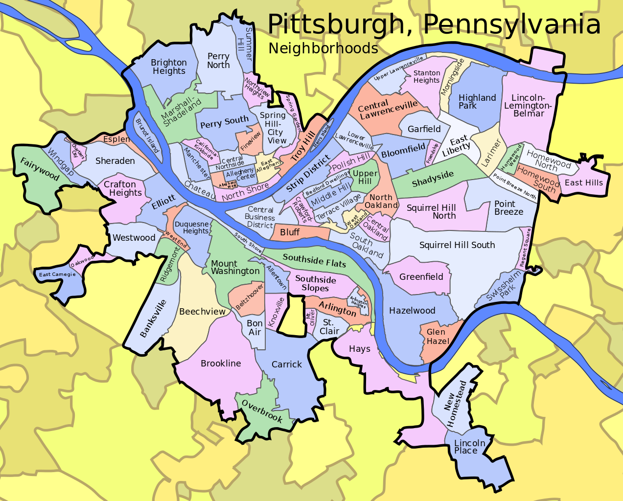
| వివరణ | A map of Pittsburgh, Pennsylvania with its neighborhoods labeled. For use primarily in the list of Pittsburgh neighborhoods. |
| తేదీ | (UTC) |
| మూలం | Created by uploader from several map sources, mainly http://www.city.pittsburgh.pa.us/cp/maps/pittsburgh.html |
| కర్త | Tom Murphy VII |
| అనుమతి (ఈ దస్త్రాన్ని పునర్వినియోగించుకోవడం) |
Use freely for any purpose, attribution appreciated |
| ఇతర కూర్పులు | See the Locator maps of Pittsburgh neighborhoods category for images with each neighborhood individually highlighted. |
లైసెన్సింగ్
| ఈ కృతిని కృతికర్త, I, Brighterorange', సార్వజనీనంగా విడుదల చేసారు. ఇది ప్రపంచవ్యాప్తంగా వర్తిస్తుంది. కొన్ని దేశాల్లో ఇది చట్టబద్ధంగా సాధ్యంకాకపోవచ్చు; అయితే: ఈ కృతిని ఎటువంటి షరతులు లేకుండా, అట్టి షరతులు చట్టం వల్ల తప్పనిసరి అయితే తప్ప, ఏ ఉద్దేశానికైనా ఉపయోగించుకునే హక్కును ఎవరికైనా I, Brighterorange ప్రదానం చేస్తున్నారు. |
ఫైలు చరితం
తేదీ/సమయం ను నొక్కి ఆ సమయాన ఫైలు ఎలా ఉండేదో చూడవచ్చు.
| తేదీ/సమయం | నఖచిత్రం | కొలతలు | వాడుకరి | వ్యాఖ్య | |
|---|---|---|---|---|---|
| ప్రస్తుత | 14:38, 19 జూలై 2007 | | 746 × 600 (293 KB) | Brighterorange | |
| 20:47, 17 జూలై 2007 |  | 746 × 600 (293 KB) | Brighterorange | {{Information |Description=A map of Pittsburgh, Pennsylvania with its neighborhoods labeled. For use primarily in the [[:en:List of Pittsburgh neighborhoods|list of Pittsburgh neig |
లింకులు
ఈ ఫైలును వాడుతున్న పేజీలు లేవు.
సార్వత్రిక ఫైలు వాడుక
ఈ దస్త్రాన్ని ఈ క్రింది ఇతర వికీలు ఉపయోగిస్తున్నాయి:
- en.wikipedia.org లో వాడుక
- en.wikinews.org లో వాడుక
- fa.wikipedia.org లో వాడుక
- fr.wikipedia.org లో వాడుక
- ja.wikipedia.org లో వాడుక
- kn.wikipedia.org లో వాడుక
- ru.wikinews.org లో వాడుక
- si.wikipedia.org లో వాడుక