దస్త్రం:Portuguese colonial war map1.PNG
మరింత స్పష్టమైన బొమ్మ లేదు.
Portuguese_colonial_war_map1.PNG (360 × 392 పిక్సెళ్ళు, ఫైలు పరిమాణం: 12 KB, MIME రకం: image/png)
This is a file from the Wikimedia Commons. Information from its description page there is shown below. Commons is a freely licensed media file repository. You can help. |

|
File:Portuguese colonial war blank map.svg is a vector version of this file. It should be used in place of this PNG file when not inferior.
File:Portuguese colonial war map1.PNG → File:Portuguese colonial war blank map.svg
For more information, see Help:SVG. |
 |
సారాంశం
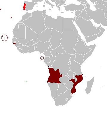
Map of the Portuguese colonies in Africa by the time of the Portuguese Colonial War (1961-1974).
Source
- English Wikipedia, uploaded by User:Mário
Revision history
12:19, 8 April 2006 . . Mário (Talk | contribs) . . 360×392 (12,409 bytes) (Map of the Portuguese colonies in Africa by the time of the Portuguese Colonial War (1961-1974).)
లైసెన్సింగ్
| నేను, ఈ కృతి యొక్క కాపీహక్కుదారుని, ఈ కృతిని సార్వజనీనం'గా విడుదల చేస్తున్నాను. ఇది ప్రపంచవ్యాప్తంగా వర్తిస్తుంది. కొన్ని దేశాల్లో ఇది చట్టబద్ధంగా సాధ్యంకాకపోవచ్చు; అయితే: ఈ కృతిని ఎటువంటి షరతులు లేకుండా, అట్టి షరతులు చట్టం వల్ల తప్పనిసరి అయితే తప్ప, ఏ ఉద్దేశానికైనా ఉపయోగించుకునే హక్కును ఎవరికైనా నేను ప్రదానం చేస్తున్నాను. |
ఫైలు చరితం
తేదీ/సమయం ను నొక్కి ఆ సమయాన ఫైలు ఎలా ఉండేదో చూడవచ్చు.
| తేదీ/సమయం | నఖచిత్రం | కొలతలు | వాడుకరి | వ్యాఖ్య | |
|---|---|---|---|---|---|
| ప్రస్తుత | 10:17, 5 మార్చి 2008 | | 360 × 392 (12 KB) | The Ogre | Enhanced visualization |
| 19:51, 26 నవంబరు 2007 |  | 360 × 392 (12 KB) | Hoshie | added Cabinda, updated base map | |
| 14:46, 12 ఆగస్టు 2006 |  | 360 × 392 (12 KB) | Nuno Tavares | == Summary == Map of the Portuguese colonies in Africa by the time of the Portuguese Colonial War (1961-1974). ==Source== <pre> 12:19, 8 April 2006 . . Mário (Talk | contribs) . . 360×392 (12,409 bytes) (Map of the Portuguese colonies i |
లింకులు
ఈ ఫైలును వాడుతున్న పేజీలు లేవు.
సార్వత్రిక ఫైలు వాడుక
ఈ దస్త్రాన్ని ఈ క్రింది ఇతర వికీలు ఉపయోగిస్తున్నాయి:
- de.wikipedia.org లో వాడుక
- en.wikipedia.org లో వాడుక
- fr.wikipedia.org లో వాడుక
- ja.wikipedia.org లో వాడుక