దస్త్రం:Racial Divide Detroit MI.png

ఈ మునుజూపు పరిమాణం: 600 × 600 పిక్సెళ్ళు. ఇతర రిజల్యూషన్లు: 240 × 240 పిక్సెళ్ళు | 480 × 480 పిక్సెళ్ళు | 768 × 768 పిక్సెళ్ళు | 1,024 × 1,024 పిక్సెళ్ళు | 2,048 × 2,048 పిక్సెళ్ళు | 3,009 × 3,009 పిక్సెళ్ళు.
అసలు దస్త్రం (3,009 × 3,009 పిక్సెళ్ళు, ఫైలు పరిమాణం: 2.15 MB, MIME రకం: image/png)
This is a file from the Wikimedia Commons. Information from its description page there is shown below. Commons is a freely licensed media file repository. You can help. |
సారాంశం
| వివరణ |
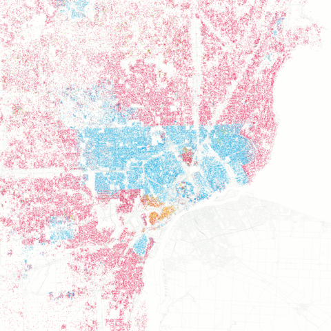
Race and ethnicity in Detroit, Michigan White African-American Asian Hispanic Other Each dot is 25 people. |
| తేదీ | |
| మూలం |
Race and ethnicity: Detroit on Flickr Data from Census 2000, base map from OpenStreetMap Uploaded by Imzadi1979 |
| కర్త | Eric Fischer |
| Camera location | | View this and other nearby images on: OpenStreetMap |
|---|
లైసెన్సింగ్
ఈ దస్త్రం క్రియేటివ్ కామన్స్ ఆపాదింపు-యథాతథ పంచుకోలు 2.0 సాధారణం లైసెన్సు క్రింద లభ్యం.
- ఇలా చేసేందుకు మీకు స్వేచ్ఛ ఉంది:
- పంచుకోడానికి – ఈ కృతిని కాపీ చేసుకోవచ్చు, పంపిణీ చేయవచ్చు, ప్రసారమూ చేయవచ్చు
- రీమిక్స్ చేయడానికి – కృతిని అనుకరించడానికి
- క్రింది షరతులకు లోబడి:
- ఆపాదింపు – సముచితమైన శ్రేయస్సును ఇవ్వాలి, లైసెన్సుకు లింకు ఇవ్వాలి, మార్పులేమైనా చేస్తే వాటిని సూచించాలి. అందుకు సముచితమైన పద్ధతి దేన్నైనా అవలంబించవచ్చు. కానీ మీకూ మీ వాడుకకూ హక్కుదారు అనుమతించారు అనే అర్థం వచ్చేటట్లుగా మాత్రం కాదు.
- share alike – మీరు ఈ కృతిని అనుకరిస్తే, మారిస్తే, లేదా మెరుగుపరిస్తే తత్ఫలిత కృతిని ఇదే లైసెన్సు లేదా దీనికి అనుగుణ్యమైన లైసెన్సు క్రింద మాత్రమే పంపిణీ చేయాలి.
| This image, originally posted to Flickr, was reviewed on September 24, 2010 by the administrator or reviewer File Upload Bot (Magnus Manske), who confirmed that it was available on Flickr under the stated license on that date. |
ఫైలు చరితం
తేదీ/సమయం ను నొక్కి ఆ సమయాన ఫైలు ఎలా ఉండేదో చూడవచ్చు.
| తేదీ/సమయం | నఖచిత్రం | కొలతలు | వాడుకరి | వ్యాఖ్య | |
|---|---|---|---|---|---|
| ప్రస్తుత | 06:50, 2 మార్చి 2013 | | 3,009 × 3,009 (2.15 MB) | JohnnyMrNinja | index colors and increase compression |
| 12:15, 24 సెప్టెంబరు 2010 |  | 3,009 × 3,009 (5.91 MB) | File Upload Bot (Magnus Manske) | {{Information |Description=I was astounded by [http://www.radicalcartography.net/index.html?chicagodots Bill Rankin's map of Chicago's racial and ethnic divides] and wanted to see what other cities looked like mapped the same way. To match his map, Red i |
లింకులు
కింది పేజీలలో ఈ ఫైలుకు లింకులు ఉన్నాయి:
సార్వత్రిక ఫైలు వాడుక
ఈ దస్త్రాన్ని ఈ క్రింది ఇతర వికీలు ఉపయోగిస్తున్నాయి:
- de.wikipedia.org లో వాడుక
- en.wikipedia.org లో వాడుక
- he.wikivoyage.org లో వాడుక
- www.wikidata.org లో వాడుక