దస్త్రం:SatavahanaMap.jpg

ఈ మునుజూపు పరిమాణం: 467 × 599 పిక్సెళ్ళు. ఇతర రిజల్యూషన్లు: 187 × 240 పిక్సెళ్ళు | 374 × 480 పిక్సెళ్ళు | 599 × 768 పిక్సెళ్ళు | 1,123 × 1,440 పిక్సెళ్ళు.
అసలు దస్త్రం (1,123 × 1,440 పిక్సెళ్ళు, ఫైలు పరిమాణం: 327 KB, MIME రకం: image/jpeg)
This is a file from the Wikimedia Commons. Information from its description page there is shown below. Commons is a freely licensed media file repository. You can help. |

|
This map has been uploaded by Electionworld from en.wikipedia.org to enable the |

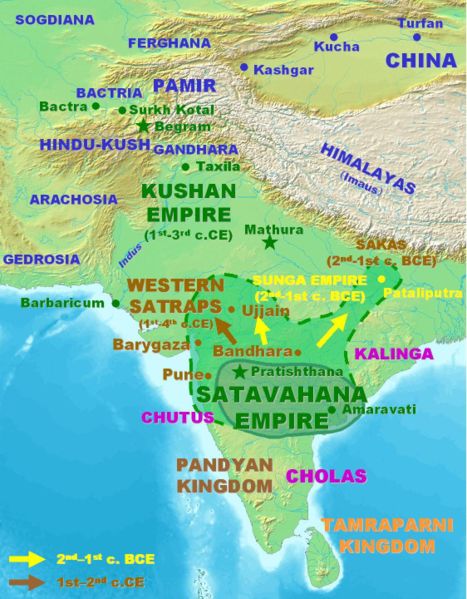
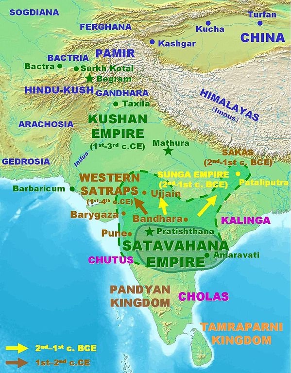
Approximate extent of the Satavahana Empire.
Personal map, 2005. Released in the Public Domain.
| ఈ కృతిని కృతికర్త, PHG, సార్వజనీనంగా విడుదల చేసారు. ఇది ప్రపంచవ్యాప్తంగా వర్తిస్తుంది. కొన్ని దేశాల్లో ఇది చట్టబద్ధంగా సాధ్యంకాకపోవచ్చు; అయితే: |
ఫైలు చరితం
తేదీ/సమయం ను నొక్కి ఆ సమయాన ఫైలు ఎలా ఉండేదో చూడవచ్చు.
| తేదీ/సమయం | నఖచిత్రం | కొలతలు | వాడుకరి | వ్యాఖ్య | |
|---|---|---|---|---|---|
| ప్రస్తుత | 14:09, 18 మార్చి 2007 | | 1,123 × 1,440 (327 KB) | World Imaging | Better map, personal creation. |
| 23:21, 13 డిసెంబరు 2006 |  | 395 × 432 (29 KB) | Electionworld | {{ew|en|PHG}} {{POV-map}} Approximate extent of the Satavahana Empire. Personal map, 2005. Released in the Public Domain. {{pd}} |
లింకులు
కింది పేజీలలో ఈ ఫైలుకు లింకులు ఉన్నాయి:
సార్వత్రిక ఫైలు వాడుక
ఈ దస్త్రాన్ని ఈ క్రింది ఇతర వికీలు ఉపయోగిస్తున్నాయి:
- ba.wikipedia.org లో వాడుక
- bn.wikipedia.org లో వాడుక
- ca.wikipedia.org లో వాడుక
- cs.wikipedia.org లో వాడుక
- cv.wikipedia.org లో వాడుక
- de.wikipedia.org లో వాడుక
- en.wikipedia.org లో వాడుక
- es.wikipedia.org లో వాడుక
- eu.wikipedia.org లో వాడుక
- fa.wikipedia.org లో వాడుక
- fi.wikipedia.org లో వాడుక
- fr.wikipedia.org లో వాడుక
- hi.wikipedia.org లో వాడుక
- hy.wikipedia.org లో వాడుక
- id.wikipedia.org లో వాడుక
- id.wikibooks.org లో వాడుక
- it.wikipedia.org లో వాడుక
- kn.wikipedia.org లో వాడుక
- ko.wikipedia.org లో వాడుక
- lt.wikipedia.org లో వాడుక
- mr.wikipedia.org లో వాడుక
- nl.wikipedia.org లో వాడుక
- pnb.wikipedia.org లో వాడుక
- ru.wikipedia.org లో వాడుక
- sa.wikipedia.org లో వాడుక
- sh.wikipedia.org లో వాడుక
- si.wikipedia.org లో వాడుక
- sq.wikipedia.org లో వాడుక
- sr.wikipedia.org లో వాడుక
- th.wikipedia.org లో వాడుక
- tl.wikipedia.org లో వాడుక
- tt.wikipedia.org లో వాడుక
- uk.wikipedia.org లో వాడుక
- ur.wikipedia.org లో వాడుక
ఈ దస్త్రపు మరింత సార్వత్రిక వాడుకను చూడండి.