దస్త్రం:Schengenzone.svg

ఈ ఫైలు SVG కు చెందిన ఈ మునుజూపు PNG పరిమాణం: 560 × 599 పిక్సెళ్ళు. ఇతర రిజల్యూషన్లు: 224 × 240 పిక్సెళ్ళు | 449 × 480 పిక్సెళ్ళు | 718 × 768 పిక్సెళ్ళు | 957 × 1,024 పిక్సెళ్ళు | 1,914 × 2,048 పిక్సెళ్ళు | 645 × 690 పిక్సెళ్ళు.
అసలు దస్త్రం (SVG ఫైలు, నామమాత్రంగా 645 × 690 పిక్సెళ్ళు, ఫైలు పరిమాణం: 358 KB)
This is a file from the Wikimedia Commons. Information from its description page there is shown below. Commons is a freely licensed media file repository. You can help. |
సారాంశం
| వివరణ |
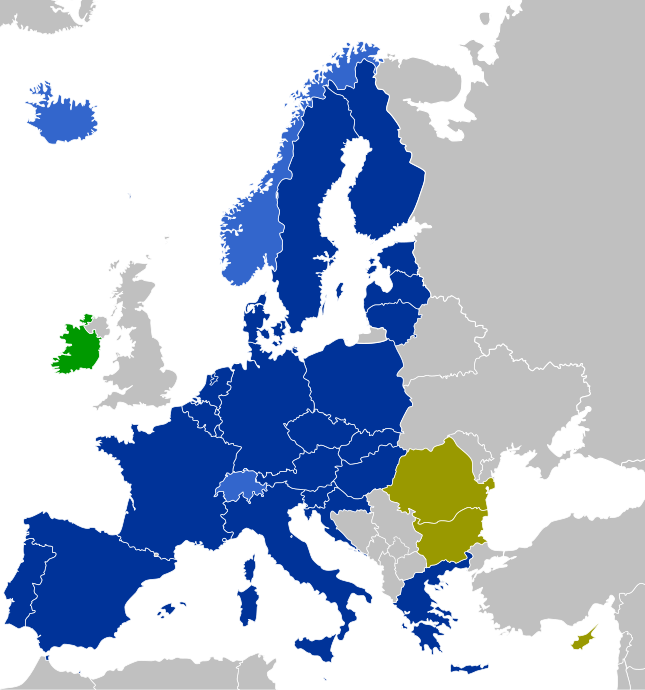
Navy: Fully participating Schengen members (EU member states which have implemented the Schengen Agreement)
Blue: Associated Schengen members (non-EU member states which have implemented the Schengen Agreement)
Purple: Members of the Schengen Area (air and maritime borders only)
Olive: Other EU member states (EU member states which have not implemented the Schengen Agreement)
Green: States which apply only some Schengen laws |
| తేదీ | |
| మూలం | స్వంత కృతి |
| కర్త | CrazyPhunk |
| ఇతర కూర్పులు | There is similar map Schengen Area participation.svg existing. |
| SVG పెరుగుదల |
లైసెన్సింగ్
| నేను, ఈ కృతి యొక్క కాపీహక్కుదారుని, ఈ కృతిని సార్వజనీనం'గా విడుదల చేస్తున్నాను. ఇది ప్రపంచవ్యాప్తంగా వర్తిస్తుంది. కొన్ని దేశాల్లో ఇది చట్టబద్ధంగా సాధ్యంకాకపోవచ్చు; అయితే: ఈ కృతిని ఎటువంటి షరతులు లేకుండా, అట్టి షరతులు చట్టం వల్ల తప్పనిసరి అయితే తప్ప, ఏ ఉద్దేశానికైనా ఉపయోగించుకునే హక్కును ఎవరికైనా నేను ప్రదానం చేస్తున్నాను. |
ఫైలు చరితం
తేదీ/సమయం ను నొక్కి ఆ సమయాన ఫైలు ఎలా ఉండేదో చూడవచ్చు.
| తేదీ/సమయం | నఖచిత్రం | కొలతలు | వాడుకరి | వ్యాఖ్య | |
|---|---|---|---|---|---|
| ప్రస్తుత | 13:01, 2 జనవరి 2023 | | 645 × 690 (358 KB) | Iktsokh | Correction of borders |
| 00:43, 1 జనవరి 2023 |  | 645 × 690 (478 KB) | Kamran.nef | Added Croatia | |
| 19:22, 9 జూన్ 2021 |  | 645 × 690 (477 KB) | Geo.smart | Reverted to version as of 13:12, 1 January 2021 (UTC) UK is a part of neither EU nor the Schengenzone | |
| 18:26, 2 జనవరి 2021 |  | 645 × 690 (477 KB) | Opihuck | Reverted to version as of 23:02, 4 February 2020 (UTC) | |
| 13:12, 1 జనవరి 2021 |  | 645 × 690 (477 KB) | Ärrännä | Reverted to version as of 01:32, 1 February 2020 (UTC) because now United Kingdom is not anymore part of EU | |
| 23:02, 4 ఫిబ్రవరి 2020 |  | 645 × 690 (477 KB) | Opihuck | Reverted to version as of 21:43, 20 February 2017 (UTC) - GB und IRL continue to be associated at least until end of 2020 | |
| 01:32, 1 ఫిబ్రవరి 2020 |  | 645 × 690 (477 KB) | Tohaomg | Brexit | |
| 21:43, 20 ఫిబ్రవరి 2017 |  | 645 × 690 (477 KB) | Nablicus | lakes removed | |
| 12:23, 21 ఆగస్టు 2015 |  | 645 × 690 (526 KB) | DaB. | Lakes, no Boarders. | |
| 07:38, 16 నవంబరు 2014 |  | 645 × 690 (531 KB) | Nablicus | Reverted to version as of 10:13, 30 June 2013. Romania and Bulgaria have not implemented all parts of the Schengen aquis |
లింకులు
కింది పేజీలలో ఈ ఫైలుకు లింకులు ఉన్నాయి:
సార్వత్రిక ఫైలు వాడుక
ఈ దస్త్రాన్ని ఈ క్రింది ఇతర వికీలు ఉపయోగిస్తున్నాయి:
- af.wikipedia.org లో వాడుక
- als.wikipedia.org లో వాడుక
- ar.wikipedia.org లో వాడుక
- arz.wikipedia.org లో వాడుక
- bg.wikipedia.org లో వాడుక
- bn.wikipedia.org లో వాడుక
- ca.wikipedia.org లో వాడుక
- cs.wikipedia.org లో వాడుక
- de.wikipedia.org లో వాడుక
- Schengener Abkommen
- Schengener Informationssystem
- Dezember 2008
- Dezember 2011
- Wikipedia:Kartenwerkstatt/Archiv/2011-05
- Verordnung (EG) Nr. 539/2001 (EU-Visum-Verordnung)
- Verordnung (EU) 2016/399 (Schengener Grenzkodex)
- Diskussion:Flüchtlingskrise in Europa 2015/2016/Archiv/2
- Verordnung (EG) Nr. 810/2009 (Visakodex)
- Benutzer:Tmid
- Portal:Migration und Integration/Artikel des Monats
- Einreise-/Ausreisesystem
- Europäisches Reiseinformations- und ‑genehmigungssystem
- Benutzer:Opihuck/Verordnung (EG) Nr. 539/2001 (EU-Visum-Verordnung)
- Extrempunkte der Europäischen Union
- Benutzer:Kpfiwa/Spielwiese/Test
- Benutzer:Valo139
- Benutzer:Wandelndes Lexikon/alt
- Benutzer:Wandelndes Lexikon/Babel
- Benutzer:Wandelndes Lexikon/Babel/Schengen-Raum
- Benutzer:Wandelndes Lexikon/Babel-Block/Herkunft
- Benutzer:Wandelndes Lexikon/Babel-Block
- Benutzer:Wandelndes Lexikon
- de.wikibooks.org లో వాడుక
- de.wikinews.org లో వాడుక
- en.wikipedia.org లో వాడుక
- en.wikibooks.org లో వాడుక
- en.wikinews.org లో వాడుక
- es.wikipedia.org లో వాడుక
- eu.wikipedia.org లో వాడుక
- fi.wikipedia.org లో వాడుక
- fr.wikipedia.org లో వాడుక
ఈ దస్త్రపు మరింత సార్వత్రిక వాడుకను చూడండి.