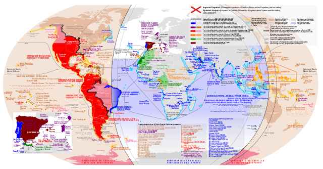
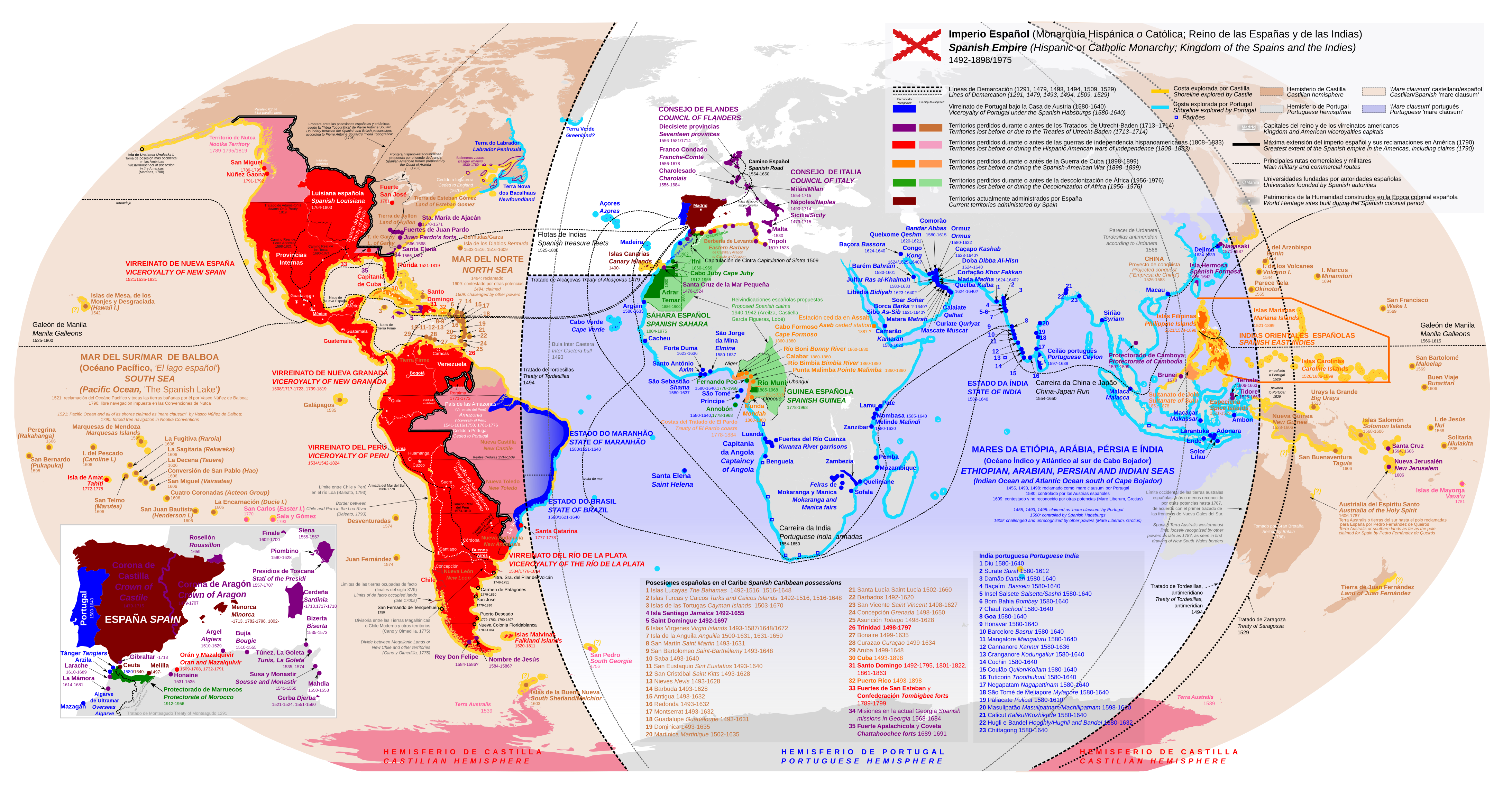
దస్త్రం:Diachronic map of the Spanish Empire.svg

ఈ ఫైలు SVG కు చెందిన ఈ మునుజూపు PNG పరిమాణం: 800 × 418 పిక్సెళ్ళు. ఇతర రిజల్యూషన్లు: 320 × 167 పిక్సెళ్ళు | 640 × 334 పిక్సెళ్ళు | 1,024 × 535 పిక్సెళ్ళు | 1,280 × 669 పిక్సెళ్ళు | 2,560 × 1,338 పిక్సెళ్ళు | 4,371 × 2,284 పిక్సెళ్ళు.
అసలు దస్త్రం (SVG ఫైలు, నామమాత్రంగా 4,371 × 2,284 పిక్సెళ్ళు, ఫైలు పరిమాణం: 6.47 MB)
This is a file from the Wikimedia Commons. Information from its description page there is shown below. Commons is a freely licensed media file repository. You can help. |
సారాంశం
| వివరణ |
English: Diachronic map of the Spanish Empire
Español: Mapa diacrónico del Imperio Español |
| తేదీ | |
| మూలం | Original map of Trasamundo, it has been redrawn from scratch and modified including territorial claims (Nagihuin)+Small correction in colouring of the Viceroyalty of Río de La Plata |
| కర్త | Nagihuin |
| ఇతర కూర్పులు |
[]
|


లైసెన్సింగ్
నేను, ఈ కృతి యొక్క కాపీహక్కుదారుని, దీన్ని ఈ లైసెన్సు క్రింద ఇందుమూలముగా ప్రచురిస్తున్నాను:
This file is licensed under the Creative Commons Attribution-Share Alike 4.0 International license.
- ఇలా చేసేందుకు మీకు స్వేచ్ఛ ఉంది:
- పంచుకోడానికి – ఈ కృతిని కాపీ చేసుకోవచ్చు, పంపిణీ చేయవచ్చు, ప్రసారమూ చేయవచ్చు
- రీమిక్స్ చేయడానికి – కృతిని అనుకరించడానికి
- క్రింది షరతులకు లోబడి:
- ఆపాదింపు – సముచితమైన శ్రేయస్సును ఇవ్వాలి, లైసెన్సుకు లింకు ఇవ్వాలి, మార్పులేమైనా చేస్తే వాటిని సూచించాలి. అందుకు సముచితమైన పద్ధతి దేన్నైనా అవలంబించవచ్చు. కానీ మీకూ మీ వాడుకకూ హక్కుదారు అనుమతించారు అనే అర్థం వచ్చేటట్లుగా మాత్రం కాదు.
- share alike – మీరు ఈ కృతిని అనుకరిస్తే, మారిస్తే, లేదా మెరుగుపరిస్తే తత్ఫలిత కృతిని ఇదే లైసెన్సు లేదా దీనికి అనుగుణ్యమైన లైసెన్సు క్రింద మాత్రమే పంపిణీ చేయాలి.
ఫైలు చరితం
తేదీ/సమయం ను నొక్కి ఆ సమయాన ఫైలు ఎలా ఉండేదో చూడవచ్చు.
| తేదీ/సమయం | నఖచిత్రం | కొలతలు | వాడుకరి | వ్యాఖ్య | |
|---|---|---|---|---|---|
| ప్రస్తుత | 10:12, 12 ఆగస్టు 2023 | | 4,371 × 2,284 (6.47 MB) | Nagihuin | Added references: Empresa de China, Terra Verde, Soulard's boundaries |
| 15:59, 14 ఫిబ్రవరి 2023 |  | 4,371 × 2,284 (6.47 MB) | Janitoalevic | Cano y Olmedilla border, San Fernando de Tenquehuén. | |
| 17:35, 21 ఆగస్టు 2022 |  | 4,371 × 2,284 (6.46 MB) | Janitoalevic | Text color | |
| 17:32, 21 ఆగస్టు 2022 |  | 4,371 × 2,284 (6.46 MB) | Janitoalevic | Added Terra Australis | |
| 15:59, 21 ఆగస్టు 2022 |  | 4,371 × 2,284 (6.46 MB) | Janitoalevic | Límite entre Chile y Perú en el río Loa (Baleato, 1793) Border between Chile and Peru in the Loa River (Baleato, 1793) | |
| 19:17, 12 డిసెంబరు 2020 |  | 4,371 × 2,284 (6.46 MB) | James2813 | Typo. | |
| 11:52, 10 ఫిబ్రవరి 2020 |  | 4,371 × 2,284 (6.47 MB) | Barjimoa | Restored repaired and corrected version per consensus on the talk page. JuTa's edits were on good faith. I also presented my case for keeping at the discussion for deletion so that the file can now be saved. | |
| 12:16, 6 ఫిబ్రవరి 2020 |  | 4,371 × 2,284 (6.47 MB) | JuTa | The other one is still available at File:Imperio Español Completo.svg | |
| 11:31, 6 ఫిబ్రవరి 2020 |  | 4,371 × 2,284 (6.47 MB) | Barjimoa | Per discussions. | |
| 21:06, 25 జనవరి 2020 |  | 4,371 × 2,284 (6.47 MB) | JuTa | The other one is available at File:Imperio Español Completo.svg |
లింకులు
కింది పేజీలలో ఈ ఫైలుకు లింకులు ఉన్నాయి:
సార్వత్రిక ఫైలు వాడుక
ఈ దస్త్రాన్ని ఈ క్రింది ఇతర వికీలు ఉపయోగిస్తున్నాయి:
- af.wikipedia.org లో వాడుక
- ar.wikipedia.org లో వాడుక
- azb.wikipedia.org లో వాడుక
- cs.wikipedia.org లో వాడుక
- de.wikipedia.org లో వాడుక
- el.wikipedia.org లో వాడుక
- en.wikipedia.org లో వాడుక
- es.wikipedia.org లో వాడుక
- fr.wikipedia.org లో వాడుక
- ht.wikipedia.org లో వాడుక
- hu.wikipedia.org లో వాడుక
- lo.wikipedia.org లో వాడుక
- nl.wikipedia.org లో వాడుక
- pt.wikipedia.org లో వాడుక
- tr.wikipedia.org లో వాడుక
- uk.wikipedia.org లో వాడుక
- vi.wikipedia.org లో వాడుక