దస్త్రం:Spreading ridges volcanoes map-en.svg

ఈ ఫైలు SVG కు చెందిన ఈ మునుజూపు PNG పరిమాణం: 800 × 402 పిక్సెళ్ళు. ఇతర రిజల్యూషన్లు: 320 × 161 పిక్సెళ్ళు | 640 × 322 పిక్సెళ్ళు | 1,024 × 515 పిక్సెళ్ళు | 1,280 × 643 పిక్సెళ్ళు | 2,560 × 1,286 పిక్సెళ్ళు | 4,995 × 2,510 పిక్సెళ్ళు.
అసలు దస్త్రం (SVG ఫైలు, నామమాత్రంగా 4,995 × 2,510 పిక్సెళ్ళు, ఫైలు పరిమాణం: 1.29 MB)
This is a file from the Wikimedia Commons. Information from its description page there is shown below. Commons is a freely licensed media file repository. You can help. |
సారాంశం
| వివరణ |
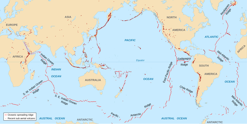
English: World map in English showing the divergent plate boundaries (OSR – Oceanic Spreading Ridges) and recent sub aerial volcanoes.
Français : Carte en anglais des dorsales océaniques et volcans terrestres récents. |
||
| తేదీ | 2006-10, upgraded 2015-09 | ||
| మూలం |
|
||
| కర్త | Eric Gaba (Sting - fr:Sting) | ||
| అనుమతి (ఈ దస్త్రాన్ని పునర్వినియోగించుకోవడం) |
|
||
| ఇతర కూర్పులు |
|

The Data source link above is now dead. Potentially active/active volcanoes appear to have been mapped if erupted within about last 10,000 odd years with an accuracy of about 50 km (31 mi) onto current basemap. Some active volcanoes are not shown and divergent plate boundaries may have inaccuracies. The map has not been updated since 2015.
లైసెన్సింగ్
నేను, ఈ కృతి యొక్క కాపీహక్కుదారుని, దీన్ని ఈ లైసెన్సు క్రింద ఇందుమూలముగా ప్రచురిస్తున్నాను:
ఈ దస్త్రం క్రియేటివ్ కామన్స్ ఆపాదింపు-యథాతథ పంచుకోలు 2.5 సాధారణం లైసెన్సు క్రింద లభ్యం.
- ఇలా చేసేందుకు మీకు స్వేచ్ఛ ఉంది:
- పంచుకోడానికి – ఈ కృతిని కాపీ చేసుకోవచ్చు, పంపిణీ చేయవచ్చు, ప్రసారమూ చేయవచ్చు
- రీమిక్స్ చేయడానికి – కృతిని అనుకరించడానికి
- క్రింది షరతులకు లోబడి:
- ఆపాదింపు – సముచితమైన శ్రేయస్సును ఇవ్వాలి, లైసెన్సుకు లింకు ఇవ్వాలి, మార్పులేమైనా చేస్తే వాటిని సూచించాలి. అందుకు సముచితమైన పద్ధతి దేన్నైనా అవలంబించవచ్చు. కానీ మీకూ మీ వాడుకకూ హక్కుదారు అనుమతించారు అనే అర్థం వచ్చేటట్లుగా మాత్రం కాదు.
- share alike – మీరు ఈ కృతిని అనుకరిస్తే, మారిస్తే, లేదా మెరుగుపరిస్తే తత్ఫలిత కృతిని ఇదే లైసెన్సు లేదా దీనికి అనుగుణ్యమైన లైసెన్సు క్రింద మాత్రమే పంపిణీ చేయాలి.
ఫైలు చరితం
తేదీ/సమయం ను నొక్కి ఆ సమయాన ఫైలు ఎలా ఉండేదో చూడవచ్చు.
| తేదీ/సమయం | నఖచిత్రం | కొలతలు | వాడుకరి | వ్యాఖ్య | |
|---|---|---|---|---|---|
| ప్రస్తుత | 18:51, 6 సెప్టెంబరు 2015 | | 4,995 × 2,510 (1.29 MB) | Sting | New background map using NGDC WCL data |
| 12:58, 11 నవంబరు 2007 |  | 5,000 × 2,525 (913 KB) | Walké | petite correction | |
| 22:10, 23 అక్టోబరు 2006 |  | 5,000 × 2,525 (913 KB) | Sting | OCR name correction; + Red Sea OCR; + continent names | |
| 15:25, 23 అక్టోబరు 2006 |  | 5,000 × 2,525 (898 KB) | Sting | {{Information| |Description=World map in English showing the divergent plate boundaries (OSR – Oceanic Spreading Ridges) and recent sub aerial volcanoes |Source= '''Background map (modified) :''' Image:Tectonic plates (empty).svg created by [[User: |
.svg)
లింకులు
కింది పేజీలలో ఈ ఫైలుకు లింకులు ఉన్నాయి:
సార్వత్రిక ఫైలు వాడుక
ఈ దస్త్రాన్ని ఈ క్రింది ఇతర వికీలు ఉపయోగిస్తున్నాయి:
- af.wikipedia.org లో వాడుక
- as.wikipedia.org లో వాడుక
- en.wikipedia.org లో వాడుక
- en.wikiquote.org లో వాడుక
- fi.wikipedia.org లో వాడుక
- fr.wikipedia.org లో వాడుక
- gu.wikipedia.org లో వాడుక
- it.wikibooks.org లో వాడుక
- ja.wikipedia.org లో వాడుక
- ki.wikipedia.org లో వాడుక
- lij.wikipedia.org లో వాడుక
- mk.wikipedia.org లో వాడుక
- ml.wikipedia.org లో వాడుక
- mwl.wikipedia.org లో వాడుక
- pnb.wikipedia.org లో వాడుక
- pt.wikipedia.org లో వాడుక
- rm.wikipedia.org లో వాడుక
- sr.wikipedia.org లో వాడుక
- ta.wikipedia.org లో వాడుక
- tl.wikipedia.org లో వాడుక
- tr.wikipedia.org లో వాడుక
- tt.wikipedia.org లో వాడుక
- tyv.wikipedia.org లో వాడుక
- ur.wikipedia.org లో వాడుక
- vi.wikipedia.org లో వాడుక
- xh.wikipedia.org లో వాడుక