దస్త్రం:The wars of Matthias Corvinus of Hungary (1458-1490).png

ఈ మునుజూపు పరిమాణం: 597 × 599 పిక్సెళ్ళు. ఇతర రిజల్యూషన్లు: 239 × 240 పిక్సెళ్ళు | 478 × 480 పిక్సెళ్ళు | 765 × 768 పిక్సెళ్ళు | 1,020 × 1,024 పిక్సెళ్ళు | 1,700 × 1,707 పిక్సెళ్ళు.
అసలు దస్త్రం (1,700 × 1,707 పిక్సెళ్ళు, ఫైలు పరిమాణం: 637 KB, MIME రకం: image/png)
This is a file from the Wikimedia Commons. Information from its description page there is shown below. Commons is a freely licensed media file repository. You can help. |
.png)
సారాంశం
| వివరణ |
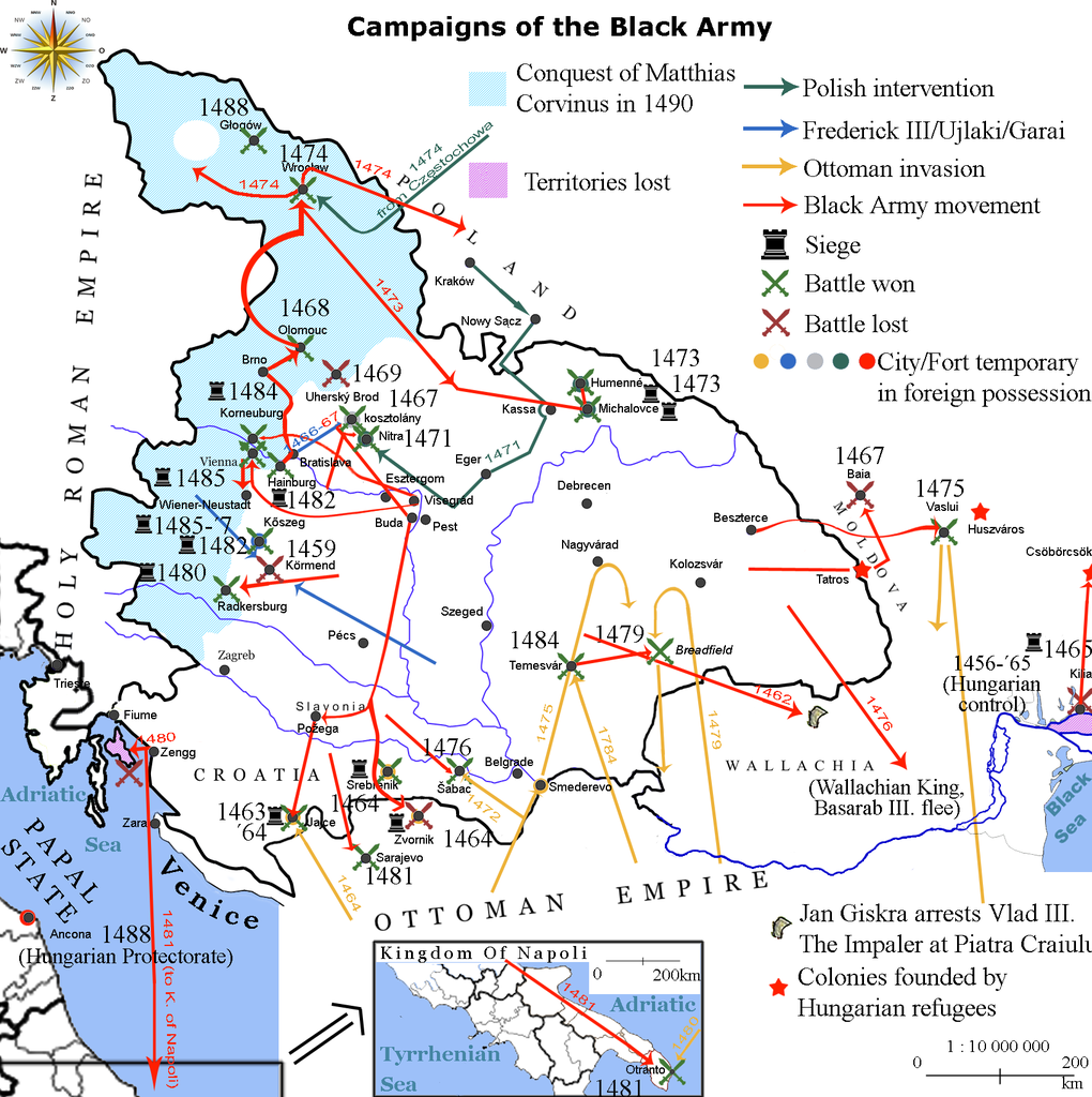
English: Map showing the direction of attacks in/of Hungary and in/of the surrounding countries in the middle of 15th century concentrating on the Black Army of Hungary. |
| తేదీ | |
| మూలం | own work based on the map Map of Hungary in 1490. Historical information is taken from Történelmi világatlasz, Budapest, Hungary, 1991, Kartográfiai Vállalat, ISBN 963-351-696-X-CM and Fenyvesi, László (1990). Mátyás Király fekete serege, Budapest, Hungary: Zrínyi Katonai Kiadó. ISBN 9633260170 Invalid ISBN. |
| కర్త | Viztarp (చర్చ · రచనలు), Alex:D (చర్చ · రచనలు) |
లైసెన్సింగ్
Lajbi at ఇంగ్లీష్ వికీపీడియా, ఈ కృతి యొక్క కాపీహక్కుదారు, దీన్ని ఇందుమూలముగా ఈ లైసెన్సు క్రింద ప్రచురిస్తున్నారు:
ఈ ఫైలు అనుమతి సాధారణ సృజనాత్మకము అపాదింపు ౩.౦ ఆన్-పోర్టెడ్ యందు అనుమతించబడినది.
ఆపాదింపు: Lajbi at ఇంగ్లీష్ వికీపీడియా
- ఇలా చేసేందుకు మీకు స్వేచ్ఛ ఉంది:
- పంచుకోడానికి – ఈ కృతిని కాపీ చేసుకోవచ్చు, పంపిణీ చేయవచ్చు, ప్రసారమూ చేయవచ్చు
- రీమిక్స్ చేయడానికి – కృతిని అనుకరించడానికి
- క్రింది షరతులకు లోబడి:
- ఆపాదింపు – సముచితమైన శ్రేయస్సును ఇవ్వాలి, లైసెన్సుకు లింకు ఇవ్వాలి, మార్పులేమైనా చేస్తే వాటిని సూచించాలి. అందుకు సముచితమైన పద్ధతి దేన్నైనా అవలంబించవచ్చు. కానీ మీకూ మీ వాడుకకూ హక్కుదారు అనుమతించారు అనే అర్థం వచ్చేటట్లుగా మాత్రం కాదు.
అసలు ఎక్కింపుల చిట్టా
The original description page was here. All following user names refer to en.wikipedia.
| తేదీ/సమయం | కొలతలు | వాడుకరి | వ్యాఖ్య |
|---|---|---|---|
| 2010-10-20 11:26 | 1700×1707× (652065 bytes) | Lajbi | distinguished Nitra from Kosztolány - corrected Moldvian campaign route |
| 2010-10-19 11:31 | 1700×1707× (649221 bytes) | Lajbi | colored the mini map - fixed the dates - added the HUungarian colonies - added Vlad Tepes' arrest |
| 2010-10-12 21:45 | 1700×1707× (631386 bytes) | Lajbi | Added coast of the Black Sea with the Danube Delta - Colored water - Added "Lost territories" |
| 2010-10-11 16:05 | 1500×1707× (577525 bytes) | Lajbi | *Fixed southern border *Added Battle of Timisosara in 1484 *Added port of Zengg as a starting place for maritine campaigns *Added first Polish intervention *Added northern powlings of Hungarian light cavalry *Added more temporary changes in cities ownersh |
| 2010-10-08 12:50 | 1500×1707× (542278 bytes) | Lajbi | {{Information |Description=Map showing the direction of attacks in/of Hungary and in/of the surrounding countries in the middle of 15th century concentrating on the Black Army of Hungary. |Source=own work based on the map [[File:Map of Hungary in 1490.png |
ఫైలు చరితం
తేదీ/సమయం ను నొక్కి ఆ సమయాన ఫైలు ఎలా ఉండేదో చూడవచ్చు.
| తేదీ/సమయం | నఖచిత్రం | కొలతలు | వాడుకరి | వ్యాఖ్య | |
|---|---|---|---|---|---|
| ప్రస్తుత | 15:36, 11 ఫిబ్రవరి 2017 | | 1,700 × 1,707 (637 KB) | OgreBot | (BOT): Reverting to most recent version before archival |
| 15:36, 11 ఫిబ్రవరి 2017 |  | 1,700 × 1,707 (634 KB) | OgreBot | (BOT): Uploading old version of file from en.wikipedia; originally uploaded on 2010-10-19 11:31:02 by Lajbi | |
| 15:36, 11 ఫిబ్రవరి 2017 |  | 1,700 × 1,707 (617 KB) | OgreBot | (BOT): Uploading old version of file from en.wikipedia; originally uploaded on 2010-10-12 21:45:52 by Lajbi | |
| 15:36, 11 ఫిబ్రవరి 2017 |  | 1,500 × 1,707 (564 KB) | OgreBot | (BOT): Uploading old version of file from en.wikipedia; originally uploaded on 2010-10-11 16:05:11 by Lajbi | |
| 15:36, 11 ఫిబ్రవరి 2017 |  | 1,500 × 1,707 (530 KB) | OgreBot | (BOT): Uploading old version of file from en.wikipedia; originally uploaded on 2010-10-08 12:50:48 by Lajbi | |
| 05:50, 11 ఫిబ్రవరి 2017 |  | 1,700 × 1,707 (637 KB) | Jarould | Transferred from en.wikipedia |
లింకులు
కింది పేజీలలో ఈ ఫైలుకు లింకులు ఉన్నాయి:
సార్వత్రిక ఫైలు వాడుక
ఈ దస్త్రాన్ని ఈ క్రింది ఇతర వికీలు ఉపయోగిస్తున్నాయి:
- ast.wikipedia.org లో వాడుక
- azb.wikipedia.org లో వాడుక
- da.wikipedia.org లో వాడుక
- de.wikipedia.org లో వాడుక
- el.wikipedia.org లో వాడుక
- en.wikipedia.org లో వాడుక
- es.wikipedia.org లో వాడుక
- et.wikipedia.org లో వాడుక
- fr.wikipedia.org లో వాడుక
- he.wikipedia.org లో వాడుక
- hr.wikipedia.org లో వాడుక
- it.wikipedia.org లో వాడుక
- pl.wikipedia.org లో వాడుక
- ro.wikipedia.org లో వాడుక
- ru.wikipedia.org లో వాడుక
- sl.wikipedia.org లో వాడుక
- sr.wikipedia.org లో వాడుక
- th.wikipedia.org లో వాడుక
- tr.wikipedia.org లో వాడుక
- uk.wikipedia.org లో వాడుక
.png)