దస్త్రం:TorresStraitIslandsMap.png

ఈ మునుజూపు పరిమాణం: 604 × 599 పిక్సెళ్ళు. ఇతర రిజల్యూషన్లు: 242 × 240 పిక్సెళ్ళు | 484 × 480 పిక్సెళ్ళు | 929 × 922 పిక్సెళ్ళు.
అసలు దస్త్రం (929 × 922 పిక్సెళ్ళు, ఫైలు పరిమాణం: 28 KB, MIME రకం: image/png)
This is a file from the Wikimedia Commons. Information from its description page there is shown below. Commons is a freely licensed media file repository. You can help. |
సారాంశం

|
This locator map image could be re-created using vector graphics as an SVG file. This has several advantages; see Commons:Media for cleanup for more information. If an SVG form of this image is available, please upload it and afterwards replace this template with
{{vector version available|new image name}}.
It is recommended to name the SVG file “TorresStraitIslandsMap.svg”—then the template Vector version available (or Vva) does not need the new image name parameter. |
| వివరణ |
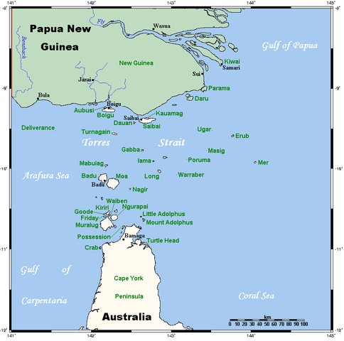
A map of the Torres Strait Islands. I have endeavoured to use native names wherever I could find them. If you can suggest ways in which this map could be made more up to date, don't hesitate to leave me a message to that effect. This map's source is here, with the uploader's modifications, and the GMT homepage says that the tools are released under the GNU General Public License. |
| తేదీ | 18 ఏప్రిల్ 2006 (original upload date) |
| మూలం | Transferred from en.wikipedia to Commons. |
| కర్త | Kelisi at ఇంగ్లీష్ వికీపీడియా |
| ఇతర కూర్పులు | Image:TorresStraitIslandsMap (zh).png |
.png)
లైసెన్సింగ్
Kelisi from en.wikipedia.org, ఈ కృతి యొక్క కాపీహక్కుదారు, దీన్ని ఇందుమూలముగా ఈ లైసెన్సు క్రింద ప్రచురిస్తున్నారు:
| ఈ దస్త్రం క్రియేటివ్ కామన్స్ Attribution-Share Alike 3.0 Unported లైసెన్సు క్రింద లభ్యం. Subject to disclaimers. | ||
| ఆపాదింపు: Kelisi from en.wikipedia.org | ||
| ||
| GFDL లైసెన్సు తాజాకరణలో భాగంగా ఈ దస్త్రానికి ఈ లైసెన్సింగు ట్యాగుని చేర్చారు. |

|
ఈ కృతి యొక్క కర్తనైన నేను, ఇక నుండీ ఈ కృతిని కాపీ చేసుకోవడానికి, పంచి పెట్టడానికి మరియు/లేదా మార్పులు-చేర్పులు చేసుకోవడానికి GFDL, లైసెన్సు వెర్షను 1.2 లేదా దాని తరువాత స్వేచ్చా సాఫ్టువేరు ఫౌండేషను విడుదలచేసే ఏ GFDL లైసెన్సు ద్వారా నయినా అనుమతి ఇస్తున్నాను; ఈ కృతిలో మార్చకూడని బాగాలు లేవు, Front-Cover పాఠం లేదు, Back-Cover పాఠం లేదు. ఈ లైసెన్సు యొక్క పత్రం నకలును "జిఎన్యూ ఉచిత డాక్యుమెంటేషను లైసెన్సు" అని పిలుస్తున్న విభాగంలో ఉంది. Subject to disclaimers. |
అసలు ఎక్కింపుల చిట్టా
The original description page was here. All following user names refer to en.wikipedia.
- 2006-04-19 00:55 Kelisi 929×922×8 (28510 bytes)
- 2006-04-18 03:38 Kelisi 929×922×8 (28133 bytes) A map of the Torres Strait Islands. I have endeavoured to use native names wherever I could find them. If you can suggest ways in which this map could be made more up to date, don't hesitate to leave me a message to that effect. This map's source is [htt
ఫైలు చరితం
తేదీ/సమయం ను నొక్కి ఆ సమయాన ఫైలు ఎలా ఉండేదో చూడవచ్చు.
| తేదీ/సమయం | నఖచిత్రం | కొలతలు | వాడుకరి | వ్యాఖ్య | |
|---|---|---|---|---|---|
| ప్రస్తుత | 06:42, 13 జనవరి 2022 | | 929 × 922 (28 KB) | Kelisi | Reverted to version as of 00:09, 1 May 2007 (UTC) Hardly; those two colours are closer to each other. |
| 17:59, 6 అక్టోబరు 2021 |  | 929 × 922 (31 KB) | Claude Zygiel | Better contrast | |
| 00:09, 1 మే 2007 |  | 929 × 922 (28 KB) | Stanmar | {{Information |Description=A map of the Torres Strait Islands. I have endeavoured to use native names wherever I could find them. If you can suggest ways in which this map could be made more up to date, don't hesitate to leave me a message to that effect. |
లింకులు
ఈ ఫైలును వాడుతున్న పేజీలు లేవు.
సార్వత్రిక ఫైలు వాడుక
ఈ దస్త్రాన్ని ఈ క్రింది ఇతర వికీలు ఉపయోగిస్తున్నాయి:
- af.wikipedia.org లో వాడుక
- als.wikipedia.org లో వాడుక
- ar.wikipedia.org లో వాడుక
- azb.wikipedia.org లో వాడుక
- ba.wikipedia.org లో వాడుక
- bg.wikipedia.org లో వాడుక
- bn.wikipedia.org లో వాడుక
- br.wikipedia.org లో వాడుక
- ca.wikipedia.org లో వాడుక
- ceb.wikipedia.org లో వాడుక
- cs.wikipedia.org లో వాడుక
- cy.wikipedia.org లో వాడుక
- da.wikipedia.org లో వాడుక
- de.wikipedia.org లో వాడుక
- Torres-Straße
- Prince-of-Wales-Insel (Queensland)
- Torres-Straits-Expedition
- Bellevue-Inseln
- Mabuiag
- Talbot-Inseln
- Boigu
- Flagge der Torres-Strait-Insulaner
- Manar-Inseln
- Thursday Island
- Horn Island (Torres Strait)
- Saibai
- Thursday-Inseln
- The Three Sisters (Torres Strait)
- Dauan
- Bet Island
- Poll Island
- Sue Island
- Murray-Inseln
- Murray Island
- Badu Island
- Moa Island
- Coconut Island (Australien)
- Yam Island
- Hammond Island
- Goods Island
- Friday Island (Torres Strait)
ఈ దస్త్రపు మరింత సార్వత్రిక వాడుకను చూడండి.