దస్త్రం:VietnamChampa1.gif

ఈ మునుజూపు పరిమాణం: 361 × 600 పిక్సెళ్ళు. ఇతర రిజల్యూషన్లు: 144 × 240 పిక్సెళ్ళు | 425 × 706 పిక్సెళ్ళు.
అసలు దస్త్రం (425 × 706 పిక్సెళ్ళు, ఫైలు పరిమాణం: 27 KB, MIME రకం: image/gif)
This is a file from the Wikimedia Commons. Information from its description page there is shown below. Commons is a freely licensed media file repository. You can help. |

|
This historical map image could be re-created using vector graphics as an SVG file. This has several advantages; see Commons:Media for cleanup for more information. If an SVG form of this image is available, please upload it and afterwards replace this template with
{{vector version available|new image name}}.
It is recommended to name the SVG file “VietnamChampa1.svg”—then the template Vector version available (or Vva) does not need the new image name parameter. |
| వివరణ |
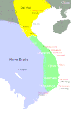
English: Southeast Asia circa 1100 C.E. showing the approximate areas of control for the Dai-Viet (Vietnam), Champa, and Khmer Empires. Note: Control of the regions away from the coast of Vietnam was more nominal than real except along the Red River.
Dai VietChampa Khmer |
||||||||
| మూలం |
|
||||||||
| కర్త | Created by CGlassey, based on maps found in DK Atlas of World History and the Times Atlas of World History. | ||||||||
| అనుమతి (ఈ దస్త్రాన్ని పునర్వినియోగించుకోవడం) |
నేను, ఈ కృతి యొక్క కాపీహక్కుదారుని, దీన్ని ఇందుమూలముగా ఈ లైసెన్సుల క్రింద ప్రచురిస్తున్నాను:
ఈ ఫైలు అనుమతి సాధారణ సృజనాత్మకము అపదింపు ౨.౫ జెనెరిక్ యందు అనుమతిన్చాబదినది.
పైవాటిలో మీకు నచ్చిన లైసెన్సునును ఎంచుకోవచ్చు. |
||||||||
| ఇతర కూర్పులు |
|


ఫైలు చరితం
తేదీ/సమయం ను నొక్కి ఆ సమయాన ఫైలు ఎలా ఉండేదో చూడవచ్చు.
| తేదీ/సమయం | నఖచిత్రం | కొలతలు | వాడుకరి | వ్యాఖ్య | |
|---|---|---|---|---|---|
| ప్రస్తుత | 04:58, 5 జూలై 2020 | | 425 × 706 (27 KB) | Sgnpkd | Updates on sites |
| 21:38, 20 జనవరి 2009 |  | 425 × 666 (8 KB) | Gryffindor | {{Information |Description= |Source=Own work by uploader |Date= |Author=Gryffindor |Permission= |other_versions= }} | |
| 21:15, 20 జనవరి 2009 |  | 425 × 666 (9 KB) | Gryffindor | {{Information |Description= |Source=Own work by uploader |Date= |Author=Gryffindor |Permission= |other_versions= }} | |
| 21:31, 7 డిసెంబరు 2006 |  | 425 × 666 (9 KB) | Electionworld | {{ew|en|Cglassey}} South East Asia circa 1100 C.E. showing the approximate areas of control for the Dai-Viet (Vietnam), Champa, and Khmer Empires. Note: Control of the regions away from the coast of Vietnam was more nominal than real except along the Red |
లింకులు
కింది పేజీలలో ఈ ఫైలుకు లింకులు ఉన్నాయి:
సార్వత్రిక ఫైలు వాడుక
ఈ దస్త్రాన్ని ఈ క్రింది ఇతర వికీలు ఉపయోగిస్తున్నాయి:
- ace.wikipedia.org లో వాడుక
- ar.wikipedia.org లో వాడుక
- azb.wikipedia.org లో వాడుక
- bn.wikipedia.org లో వాడుక
- ceb.wikipedia.org లో వాడుక
- ce.wikipedia.org లో వాడుక
- cs.wikipedia.org లో వాడుక
- da.wikipedia.org లో వాడుక
- en.wikipedia.org లో వాడుక
- eo.wikipedia.org లో వాడుక
- fa.wikipedia.org లో వాడుక
- fi.wikipedia.org లో వాడుక
- fi.wikibooks.org లో వాడుక
- fr.wikipedia.org లో వాడుక
- he.wikipedia.org లో వాడుక
- hi.wikipedia.org లో వాడుక
- hu.wikipedia.org లో వాడుక
- id.wikipedia.org లో వాడుక
- io.wikipedia.org లో వాడుక
- it.wikipedia.org లో వాడుక
- ja.wikipedia.org లో వాడుక
- km.wikipedia.org లో వాడుక
- ko.wikipedia.org లో వాడుక
- lt.wikipedia.org లో వాడుక
- min.wikipedia.org లో వాడుక
- ml.wikipedia.org లో వాడుక
- ms.wikipedia.org లో వాడుక
- new.wikipedia.org లో వాడుక
- nl.wikipedia.org లో వాడుక
- no.wikipedia.org లో వాడుక
ఈ దస్త్రపు మరింత సార్వత్రిక వాడుకను చూడండి.