దస్త్రం:Fergana valley topo political.png
మరింత స్పష్టమైన బొమ్మ లేదు.
Fergana_valley_topo_political.png (375 × 178 పిక్సెళ్ళు, ఫైలు పరిమాణం: 136 KB, MIME రకం: image/png)
This is a file from the Wikimedia Commons. Information from its description page there is shown below. Commons is a freely licensed media file repository. You can help. |
| వివరణ |
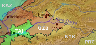
English: Map of the Fergana valley (highlighted) in Central Asia, national territories color coded, with shortened names, using boundaries from CIA 2001 Map File:Tajikistan_2001_CIA_map.jpg |
| తేదీ | (UTC) |
| మూలం | |
| కర్త |
|
| This is a retouched picture, which means that it has been digitally altered from its original version. Modifications: Overlay national territories, highlight Fergana Valley. The original can be viewed here: Syrdaryamap.png:
|
నేను, ఈ కృతి యొక్క కాపీహక్కుదారుని, దీన్ని ఇందుమూలముగా ఈ లైసెన్సుల క్రింద ప్రచురిస్తున్నాను:
ఈ దస్త్రం క్రియేటివ్ కామన్స్ ఆపాదింపు-యథాతథ పంచుకోలు 3.0 అన్పోర్టెడ్, 2.5 సాధారణం, 2.0 సాధారణం, 1.0 సాధారణం లైసెన్సుల క్రింద లభ్యం.
- ఇలా చేసేందుకు మీకు స్వేచ్ఛ ఉంది:
- పంచుకోడానికి – ఈ కృతిని కాపీ చేసుకోవచ్చు, పంపిణీ చేయవచ్చు, ప్రసారమూ చేయవచ్చు
- రీమిక్స్ చేయడానికి – కృతిని అనుకరించడానికి
- క్రింది షరతులకు లోబడి:
- ఆపాదింపు – సముచితమైన శ్రేయస్సును ఇవ్వాలి, లైసెన్సుకు లింకు ఇవ్వాలి, మార్పులేమైనా చేస్తే వాటిని సూచించాలి. అందుకు సముచితమైన పద్ధతి దేన్నైనా అవలంబించవచ్చు. కానీ మీకూ మీ వాడుకకూ హక్కుదారు అనుమతించారు అనే అర్థం వచ్చేటట్లుగా మాత్రం కాదు.
- share alike – మీరు ఈ కృతిని అనుకరిస్తే, మారిస్తే, లేదా మెరుగుపరిస్తే తత్ఫలిత కృతిని ఇదే లైసెన్సు లేదా దీనికి అనుగుణ్యమైన లైసెన్సు క్రింద మాత్రమే పంపిణీ చేయాలి.

|
ఈ కృతి యొక్క కర్తనైన నేను, ఇక నుండీ ఈ కృతిని కాపీ చేసుకోవడానికి, పంచి పెట్టడానికి మరియు/లేదా మార్పులు-చేర్పులు చేసుకోవడానికి GFDL, లైసెన్సు వెర్షను 1.2 లేదా దాని తరువాత స్వేచ్చా సాఫ్టువేరు ఫౌండేషను విడుదలచేసే ఏ GFDL లైసెన్సు ద్వారా నయినా అనుమతి ఇస్తున్నాను; ఈ కృతిలో మార్చకూడని బాగాలు లేవు, Front-Cover పాఠం లేదు, Back-Cover పాఠం లేదు. ఈ లైసెన్సు యొక్క పత్రం నకలును "జిఎన్యూ ఉచిత డాక్యుమెంటేషను లైసెన్సు" అని పిలుస్తున్న విభాగంలో ఉంది. |
పైవాటిలో మీకు నచ్చిన లైసెన్సునును ఎంచుకోవచ్చు.
అసలు ఎక్కింపుల చిట్టా
This image is a derivative work of the following images:
- File:Syrdaryamap.png licensed with Cc-by-sa-3.0,2.5,2.0,1.0, GFDL
- 2010-02-07T03:04:09Z Shannon1 1101x866 (1580396 Bytes) {{Information |Description={{en|1=Map of the watershed of the Syr Darya in Central Asia, that drains to the Aral Sea.}} |Source=Background and river course data from http://www2.demis.nl/mapserver/mapper.asp |Author=Backgrou
Uploaded with derivativeFX
ఫైలు చరితం
తేదీ/సమయం ను నొక్కి ఆ సమయాన ఫైలు ఎలా ఉండేదో చూడవచ్చు.
| తేదీ/సమయం | నఖచిత్రం | కొలతలు | వాడుకరి | వ్యాఖ్య | |
|---|---|---|---|---|---|
| ప్రస్తుత | 19:39, 14 జూన్ 2010 | | 375 × 178 (136 KB) | T L Miles | {{Information |Description={{en|1=Map of the watershed of the Syr Darya in Central Asia, that drains to the Aral Sea.}} |Source=*File:Syrdaryamap.png |Date=2010-06-14 19:38 (UTC) |Author=*File:Syrdaryamap.png: Background layer attributed to DE |
లింకులు
కింది పేజీలలో ఈ ఫైలుకు లింకులు ఉన్నాయి:
సార్వత్రిక ఫైలు వాడుక
ఈ దస్త్రాన్ని ఈ క్రింది ఇతర వికీలు ఉపయోగిస్తున్నాయి:
- da.wikipedia.org లో వాడుక
- de.wikipedia.org లో వాడుక
- de.wikivoyage.org లో వాడుక
- en.wikipedia.org లో వాడుక
- en.wikivoyage.org లో వాడుక
- fa.wikipedia.org లో వాడుక
- fi.wikipedia.org లో వాడుక
- hi.wikipedia.org లో వాడుక
- it.wikipedia.org లో వాడుక
- ml.wikipedia.org లో వాడుక
- mn.wikipedia.org లో వాడుక
- ms.wikipedia.org లో వాడుక
- pl.wikipedia.org లో వాడుక
- ro.wikipedia.org లో వాడుక
- sv.wikipedia.org లో వాడుక
- ta.wikipedia.org లో వాడుక
- th.wikipedia.org లో వాడుక
- tl.wikipedia.org లో వాడుక
- uk.wikipedia.org లో వాడుక
- zh.wikivoyage.org లో వాడుక