దస్త్రం:Partition of India 1947 en.svg

ఈ ఫైలు SVG కు చెందిన ఈ మునుజూపు PNG పరిమాణం: 609 × 599 పిక్సెళ్ళు. ఇతర రిజల్యూషన్లు: 244 × 240 పిక్సెళ్ళు | 488 × 480 పిక్సెళ్ళు | 780 × 768 పిక్సెళ్ళు | 1,041 × 1,024 పిక్సెళ్ళు | 2,081 × 2,048 పిక్సెళ్ళు | 1,189 × 1,170 పిక్సెళ్ళు.
అసలు దస్త్రం (SVG ఫైలు, నామమాత్రంగా 1,189 × 1,170 పిక్సెళ్ళు, ఫైలు పరిమాణం: 724 KB)
This is a file from the Wikimedia Commons. Information from its description page there is shown below. Commons is a freely licensed media file repository. You can help. |
సారాంశం
| వివరణ |
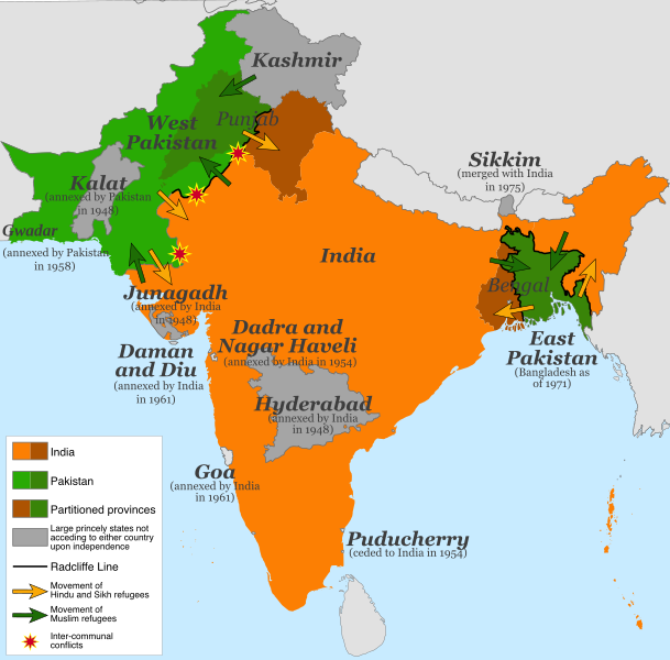
English: Map of the partition of India (1947). Note: Small princely states not acceding to either country upon independence are shown as integral parts of India and Pakistan. |
| తేదీ | |
| మూలం |
This file was derived from: |
| కర్త | స్వంత కృతి |
| ఇతర కూర్పులు |
[]
|


.svg)


.svg)
లైసెన్సింగ్
This file is licensed under the Creative Commons Attribution-Share Alike 4.0 International license.
- ఇలా చేసేందుకు మీకు స్వేచ్ఛ ఉంది:
- పంచుకోడానికి – ఈ కృతిని కాపీ చేసుకోవచ్చు, పంపిణీ చేయవచ్చు, ప్రసారమూ చేయవచ్చు
- రీమిక్స్ చేయడానికి – కృతిని అనుకరించడానికి
- క్రింది షరతులకు లోబడి:
- ఆపాదింపు – సముచితమైన శ్రేయస్సును ఇవ్వాలి, లైసెన్సుకు లింకు ఇవ్వాలి, మార్పులేమైనా చేస్తే వాటిని సూచించాలి. అందుకు సముచితమైన పద్ధతి దేన్నైనా అవలంబించవచ్చు. కానీ మీకూ మీ వాడుకకూ హక్కుదారు అనుమతించారు అనే అర్థం వచ్చేటట్లుగా మాత్రం కాదు.
- share alike – మీరు ఈ కృతిని అనుకరిస్తే, మారిస్తే, లేదా మెరుగుపరిస్తే తత్ఫలిత కృతిని ఇదే లైసెన్సు లేదా దీనికి అనుగుణ్యమైన లైసెన్సు క్రింద మాత్రమే పంపిణీ చేయాలి.
ఫైలు చరితం
తేదీ/సమయం ను నొక్కి ఆ సమయాన ఫైలు ఎలా ఉండేదో చూడవచ్చు.
| తేదీ/సమయం | నఖచిత్రం | కొలతలు | వాడుకరి | వ్యాఖ్య | |
|---|---|---|---|---|---|
| ప్రస్తుత | 13:15, 5 జూలై 2017 | | 1,189 × 1,170 (724 KB) | RaviC | some rendering adjustments |
| 13:14, 5 జూలై 2017 |  | 1,189 × 1,170 (717 KB) | RaviC | + Gwadar | |
| 02:57, 30 ఏప్రిల్ 2017 |  | 1,189 × 1,170 (661 KB) | फ़िलप्रो | Kalat and Dadra and Nagar Haveli border width. | |
| 02:46, 30 ఏప్రిల్ 2017 |  | 1,189 × 1,170 (648 KB) | फ़िलप्रो | Fixed Junagadh, location of Diu (Daman and Diu), and added Dadra and Nagar Haveli. | |
| 01:31, 30 ఏప్రిల్ 2017 |  | 1,189 × 1,170 (643 KB) | फ़िलप्रो | Added labels for other annexed princely states. Fixed shape of Bengal and Punjab provinces as per their sizes in 1947. | |
| 12:17, 11 ఫిబ్రవరి 2017 |  | 1,189 × 1,170 (433 KB) | Superbenjamin | User created page with UploadWizard |
లింకులు
కింది పేజీలలో ఈ ఫైలుకు లింకులు ఉన్నాయి:
సార్వత్రిక ఫైలు వాడుక
ఈ దస్త్రాన్ని ఈ క్రింది ఇతర వికీలు ఉపయోగిస్తున్నాయి:
- af.wikipedia.org లో వాడుక
- als.wikipedia.org లో వాడుక
- ast.wikipedia.org లో వాడుక
- az.wikipedia.org లో వాడుక
- bg.wikipedia.org లో వాడుక
- ca.wikipedia.org లో వాడుక
- da.wikipedia.org లో వాడుక
- de.wikipedia.org లో వాడుక
- de.wikiversity.org లో వాడుక
- en.wikipedia.org లో వాడుక
- es.wikipedia.org లో వాడుక
- eu.wikipedia.org లో వాడుక
- fi.wikipedia.org లో వాడుక
- ga.wikipedia.org లో వాడుక
- he.wikipedia.org లో వాడుక
- hy.wikipedia.org లో వాడుక
- id.wikipedia.org లో వాడుక
- is.wikipedia.org లో వాడుక
- ja.wikipedia.org లో వాడుక
- ka.wikipedia.org లో వాడుక
- ko.wikipedia.org లో వాడుక
- lv.wikipedia.org లో వాడుక
- ml.wikipedia.org లో వాడుక
- mr.wikipedia.org లో వాడుక
- nl.wikipedia.org లో వాడుక
- nn.wikipedia.org లో వాడుక
- nn.wikiquote.org లో వాడుక
- no.wikipedia.org లో వాడుక
- pnb.wikipedia.org లో వాడుక
- ps.wikipedia.org లో వాడుక
ఈ దస్త్రపు మరింత సార్వత్రిక వాడుకను చూడండి.