దస్త్రం:Stellardiagram-Zhengho.jpg
ఈ మునుజూపు పరిమాణం: 456 × 599 పిక్సెళ్ళు. ఇతర రిజల్యూషన్లు: 183 × 240 పిక్సెళ్ళు | 365 × 480 పిక్సెళ్ళు | 584 × 768 పిక్సెళ్ళు | 779 × 1,024 పిక్సెళ్ళు | 1,385 × 1,820 పిక్సెళ్ళు.
అసలు దస్త్రం (1,385 × 1,820 పిక్సెళ్ళు, ఫైలు పరిమాణం: 1.74 MB, MIME రకం: image/jpeg)
This is a file from the Wikimedia Commons. Information from its description page there is shown below. Commons is a freely licensed media file repository. You can help. |
సారాంశం
| కర్త |
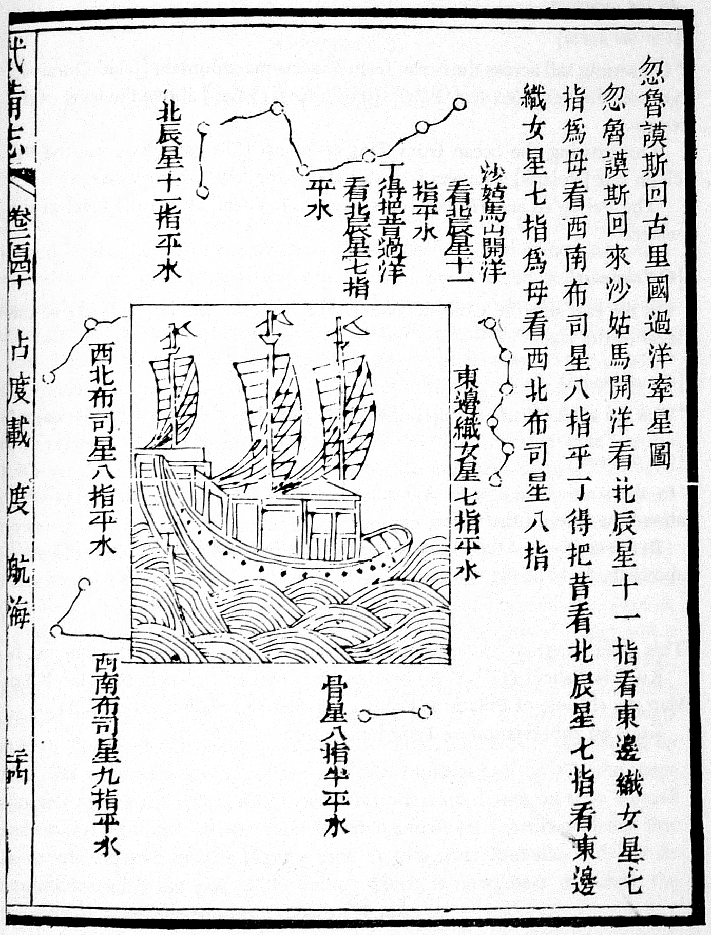
The author is unknown, but the charts were derived from works by Zheng He's expeditionary navigators during the early 15th century |
| వివరణ |
This navigational chart is one of the four stellar diagrams included in the Wubei Zhi, published in circa 1628. It appears in chapter 240, folio 24 r. The chart specifies the guiding stars enroute from Hormuz to Calicut. |
| Source/Photographer | Not given by uploader |
| ఇతర కూర్పులు |
|
| Reference | Mills, J.V.G. (1970). Ying-yai Sheng-lan: 'The Overall Survey of the Ocean's Shores' [1433]. pp. 335–346. |

లైసెన్సింగ్
|
This work is in the public domain in its country of origin and other countries and areas where the copyright term is the author's life plus 100 years or fewer. | |
| This file has been identified as being free of known restrictions under copyright law, including all related and neighboring rights. | |
ఫైలు చరితం
తేదీ/సమయం ను నొక్కి ఆ సమయాన ఫైలు ఎలా ఉండేదో చూడవచ్చు.
| తేదీ/సమయం | నఖచిత్రం | కొలతలు | వాడుకరి | వ్యాఖ్య | |
|---|---|---|---|---|---|
| ప్రస్తుత | 19:32, 1 ఆగస్టు 2015 | | 1,385 × 1,820 (1.74 MB) | Hzh | clearer image |
| 15:55, 8 డిసెంబరు 2005 |  | 588 × 800 (78 KB) | Gisling | Admiral Zheng Ho's stellar navigation diagram |
లింకులు
కింది పేజీలలో ఈ ఫైలుకు లింకులు ఉన్నాయి:
సార్వత్రిక ఫైలు వాడుక
ఈ దస్త్రాన్ని ఈ క్రింది ఇతర వికీలు ఉపయోగిస్తున్నాయి:
- af.wikipedia.org లో వాడుక
- ar.wikipedia.org లో వాడుక
- ca.wikipedia.org లో వాడుక
- cs.wikipedia.org లో వాడుక
- el.wikipedia.org లో వాడుక
- en.wikipedia.org లో వాడుక
- es.wikipedia.org లో వాడుక
- fr.wikipedia.org లో వాడుక
- it.wikipedia.org లో వాడుక
- ja.wikipedia.org లో వాడుక
- pt.wikipedia.org లో వాడుక
- ru.wikipedia.org లో వాడుక
- sl.wikipedia.org లో వాడుక
- test.wikipedia.org లో వాడుక
- uk.wikipedia.org లో వాడుక
- vi.wikipedia.org లో వాడుక
- zh.wikipedia.org లో వాడుక