దస్త్రం:Volgarivermap.png
మరింత స్పష్టమైన బొమ్మ లేదు.
Volgarivermap.png (500 × 500 పిక్సెళ్ళు, ఫైలు పరిమాణం: 155 KB, MIME రకం: image/png)
This is a file from the Wikimedia Commons. Information from its description page there is shown below. Commons is a freely licensed media file repository. You can help. |

|
This map image could be re-created using vector graphics as an SVG file. This has several advantages; see Commons:Media for cleanup for more information. If an SVG form of this image is available, please upload it and afterwards replace this template with
{{vector version available|new image name}}.
It is recommended to name the SVG file “Volgarivermap.svg”—then the template Vector version available (or Vva) does not need the new image name parameter. |
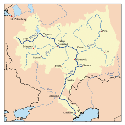
This is a map of the Volga River system. I, Karl Musser, created it based on USGS data.
నేను, ఈ కృతి యొక్క కాపీహక్కుదారుని, దీన్ని ఈ లైసెన్సు క్రింద ఇందుమూలముగా ప్రచురిస్తున్నాను:
ఈ దస్త్రం క్రియేటివ్ కామన్స్ ఆపాదింపు-యథాతథ పంచుకోలు 2.5 సాధారణం లైసెన్సు క్రింద లభ్యం.
- ఇలా చేసేందుకు మీకు స్వేచ్ఛ ఉంది:
- పంచుకోడానికి – ఈ కృతిని కాపీ చేసుకోవచ్చు, పంపిణీ చేయవచ్చు, ప్రసారమూ చేయవచ్చు
- రీమిక్స్ చేయడానికి – కృతిని అనుకరించడానికి
- క్రింది షరతులకు లోబడి:
- ఆపాదింపు – సముచితమైన శ్రేయస్సును ఇవ్వాలి, లైసెన్సుకు లింకు ఇవ్వాలి, మార్పులేమైనా చేస్తే వాటిని సూచించాలి. అందుకు సముచితమైన పద్ధతి దేన్నైనా అవలంబించవచ్చు. కానీ మీకూ మీ వాడుకకూ హక్కుదారు అనుమతించారు అనే అర్థం వచ్చేటట్లుగా మాత్రం కాదు.
- share alike – మీరు ఈ కృతిని అనుకరిస్తే, మారిస్తే, లేదా మెరుగుపరిస్తే తత్ఫలిత కృతిని ఇదే లైసెన్సు లేదా దీనికి అనుగుణ్యమైన లైసెన్సు క్రింద మాత్రమే పంపిణీ చేయాలి.
derivative works
Derivative works of this file:
ఫైలు చరితం
తేదీ/సమయం ను నొక్కి ఆ సమయాన ఫైలు ఎలా ఉండేదో చూడవచ్చు.
| తేదీ/సమయం | నఖచిత్రం | కొలతలు | వాడుకరి | వ్యాఖ్య | |
|---|---|---|---|---|---|
| ప్రస్తుత | 17:06, 23 జూలై 2007 | | 500 × 500 (155 KB) | Kmusser | Ural river fix |
| 14:50, 17 అక్టోబరు 2006 |  | 500 × 500 (40 KB) | Kmusser | ||
| 20:15, 31 ఆగస్టు 2006 |  | 500 × 500 (126 KB) | Kmusser | This is a map of the Volga River system. I, Karl Musser, created it based on USGS data. {{self|cc-by-sa-2.5}} Category:Maps of rivers |
లింకులు
కింది పేజీలలో ఈ ఫైలుకు లింకులు ఉన్నాయి:
సార్వత్రిక ఫైలు వాడుక
ఈ దస్త్రాన్ని ఈ క్రింది ఇతర వికీలు ఉపయోగిస్తున్నాయి:
- af.wikipedia.org లో వాడుక
- als.wikipedia.org లో వాడుక
- ang.wikipedia.org లో వాడుక
- an.wikipedia.org లో వాడుక
- ar.wikipedia.org లో వాడుక
- arz.wikipedia.org లో వాడుక
- ast.wikipedia.org లో వాడుక
- as.wikipedia.org లో వాడుక
- avk.wikipedia.org లో వాడుక
- Tsna (kuksa ke Mokca)
- Volga (kuksa)
- Teza:VolgaBost
- Samara (kuksa)
- Borovka (kuksa)
- Tok (kuksa)
- Bolcoy Uran (kuksa)
- Mali Uran (kuksa)
- Bolcoy Kinel (kuksa)
- Buzuluk ke Volga (kuksa)
- Bolcoy Irgiz (kuksa)
- Kamelik (kuksa)
- Bolcaya Tcalikla (kuksa)
- Bolcoy Kucum (kuksa)
- Sura (kuksa)
- Alatir (kuksa)
- Baric (kuksa)
- Teza:SuraKuksa
- Teza:SamaraKuksa
- Teza:BolcoyIrgizKuksa
- Kadada (kuksa)
- Uza (kuksa)
- Ugra (kuksa ke Sura)
- Pyana (kuksa)
- Bezdna (kuksa)
- Inza (kuksa)
- Kirya (kuksa)
- Insar (kuksa)
- Oka (kuksa)
- Teza:OkaKuksa
- Mokca (kuksa)
ఈ దస్త్రపు మరింత సార్వత్రిక వాడుకను చూడండి.