దస్త్రం:Wien Besatzungszonen.png

ఈ మునుజూపు పరిమాణం: 800 × 407 పిక్సెళ్ళు. ఇతర రిజల్యూషన్లు: 320 × 163 పిక్సెళ్ళు | 640 × 325 పిక్సెళ్ళు | 1,400 × 712 పిక్సెళ్ళు.
అసలు దస్త్రం (1,400 × 712 పిక్సెళ్ళు, ఫైలు పరిమాణం: 92 KB, MIME రకం: image/png)
This is a file from the Wikimedia Commons. Information from its description page there is shown below. Commons is a freely licensed media file repository. You can help. |

|
This city map image could be re-created using vector graphics as an SVG file. This has several advantages; see Commons:Media for cleanup for more information. If an SVG form of this image is available, please upload it and afterwards replace this template with
{{vector version available|new image name}}.
It is recommended to name the SVG file “Wien Besatzungszonen.svg”—then the template Vector version available (or Vva) does not need the new image name parameter. |
| వివరణ |
|
| తేదీ | |
| మూలం |
|
| కర్త | Christoph Lingg |
| అనుమతి (ఈ దస్త్రాన్ని పునర్వినియోగించుకోవడం) |
ఈ దస్త్రం క్రియేటివ్ కామన్స్ ఆపాదింపు-యథాతథ పంచుకోలు 2.0 జర్మనీ లైసెన్సు క్రింద లభ్యం.
 |
![[1]](http://www.aeiou.at/aeiou.encyclop.data.image.b/b397245b.jpg)
ఫైలు చరితం
తేదీ/సమయం ను నొక్కి ఆ సమయాన ఫైలు ఎలా ఉండేదో చూడవచ్చు.
| తేదీ/సమయం | నఖచిత్రం | కొలతలు | వాడుకరి | వ్యాఖ్య | |
|---|---|---|---|---|---|
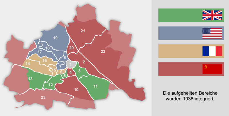
| ప్రస్తుత | 15:16, 21 నవంబరు 2018 | | 1,400 × 712 (92 KB) | Hanzlan | Albern war bis 1954 Teil des sowjetisch besetzten Niederösterreich, daher hellrot umgefärbt, ebenso kleine Teile des 14. und 19. Bezirks. |
| 11:05, 8 జనవరి 2017 |  | 1,400 × 712 (92 KB) | Foghe | Reverted to version as of 11:53, 16 March 2016 (UTC) Better colours (like the map of Austria) and biggest dimensions. | |
| 14:15, 27 డిసెంబరు 2016 |  | 1,280 × 651 (198 KB) | Paasikivi | väri vahvistus colour strengthening | |
| 11:53, 16 మార్చి 2016 |  | 1,400 × 712 (92 KB) | Kontrollstellekundl | original flag colors | |
| 15:41, 9 జనవరి 2009 |  | 1,400 × 712 (78 KB) | C.lingg | {{Information |Description=changed the "erste Bezirk" it was under control of all 4 countries |Source=myself |Date=09.01.2009 |Author=Christoph Lingg, ~~ |Permission={{cc-by-sa-2.0-de}} |other_versions= }} | |
| 13:43, 14 సెప్టెంబరు 2008 |  | 1,400 × 712 (106 KB) | IJA | Vereinigtes Königreich ist das Grün. | |
| 13:42, 14 సెప్టెంబరు 2008 |  | 1,400 × 712 (107 KB) | IJA | Vereinigtes Königreich ist das Grün. | |
| 14:00, 14 అక్టోబరు 2007 |  | 1,400 × 712 (78 KB) | C.lingg | fixed the amrican flag, it contains now 48 stars. {{Bild-CC-by-sa/2.0/de}})</nowiki>'' |Date= 2005-08-21 |Author= Christoph Lingg |Permission= {{cc-by-sa-2.0-de}} |other_versions= }} | |
| 10:14, 30 అక్టోబరు 2005 |  | 1,400 × 712 (78 KB) | Martg76~commonswiki | Author: Christoph Lingg Date: August 21, 2005 Source URL: [http://de.wikipedia.org/wiki/Bild:Wien_Besatzungszonen.png] |
లింకులు
కింది పేజీలలో ఈ ఫైలుకు లింకులు ఉన్నాయి:
సార్వత్రిక ఫైలు వాడుక
ఈ దస్త్రాన్ని ఈ క్రింది ఇతర వికీలు ఉపయోగిస్తున్నాయి:
- ar.wikipedia.org లో వాడుక
- be-tarask.wikipedia.org లో వాడుక
- be.wikipedia.org లో వాడుక
- bn.wikipedia.org లో వాడుక
- bs.wikipedia.org లో వాడుక
- cs.wikipedia.org లో వాడుక
- da.wikipedia.org లో వాడుక
- de.wikipedia.org లో వాడుక
- el.wikipedia.org లో వాడుక
- en.wikipedia.org లో వాడుక
- es.wikipedia.org లో వాడుక
- et.wikipedia.org లో వాడుక
- fr.wikipedia.org లో వాడుక
- hr.wikipedia.org లో వాడుక
- hu.wikipedia.org లో వాడుక
- hy.wikipedia.org లో వాడుక
- hyw.wikipedia.org లో వాడుక
- io.wikipedia.org లో వాడుక
- is.wikipedia.org లో వాడుక
- it.wikipedia.org లో వాడుక
- ja.wikipedia.org లో వాడుక
- ka.wikipedia.org లో వాడుక
- ko.wikipedia.org లో వాడుక
- la.wikipedia.org లో వాడుక
- lb.wikipedia.org లో వాడుక
- mk.wikipedia.org లో వాడుక
- ms.wikipedia.org లో వాడుక
- nl.wikipedia.org లో వాడుక
- no.wikipedia.org లో వాడుక
ఈ దస్త్రపు మరింత సార్వత్రిక వాడుకను చూడండి.