దస్త్రం:AchaemenidMapBehistunInscription.png

ఈ మునుజూపు పరిమాణం: 800 × 511 పిక్సెళ్ళు. ఇతర రిజల్యూషన్లు: 320 × 205 పిక్సెళ్ళు | 640 × 409 పిక్సెళ్ళు | 1,020 × 652 పిక్సెళ్ళు.
అసలు దస్త్రం (1,020 × 652 పిక్సెళ్ళు, ఫైలు పరిమాణం: 17 KB, MIME రకం: image/png)
This is a file from the Wikimedia Commons. Information from its description page there is shown below. Commons is a freely licensed media file repository. You can help. |
సారాంశం
| వివరణ |
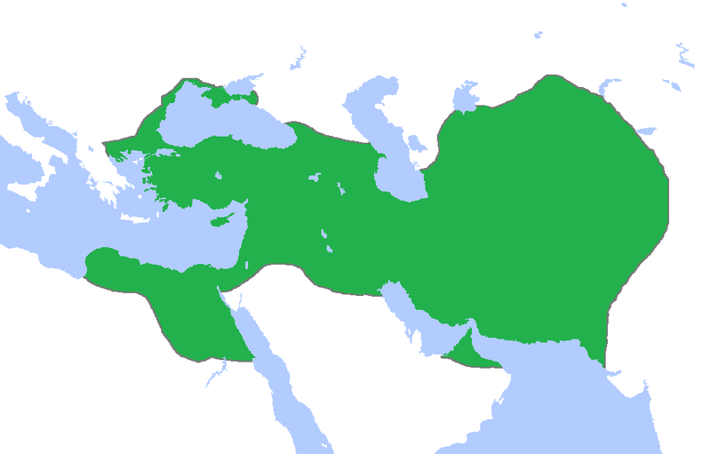
English: This a map of the Achaemenid Empire showing its greatest extent. I have given it more regions as listed on the Behistun Inscription the Persian King Darius wrote telling his conquests. |
| తేదీ | |
| మూలం | http://en.wikipedia.org/wiki/File:Achemenids500BC.png |
| కర్త | Gabagool |
| అనుమతి (ఈ దస్త్రాన్ని పునర్వినియోగించుకోవడం) |
http://en.wikipedia.org/wiki/File:Achemenids500BC.png |
- Other information
English: This is a map I have edited from that map and it says that I am free to share, to remix, but under the following conditions that i must the work in the manner specified by the author or licensor.
ఈ ఫైలుని క్రియేటివ్ కామన్స్ అట్రిబ్యూషన్ 1.0 జెనరిక్ లైసెన్సుకి లోబడి అందిస్తున్నారు.
- ఇలా చేసేందుకు మీకు స్వేచ్ఛ ఉంది:
- పంచుకోడానికి – ఈ కృతిని కాపీ చేసుకోవచ్చు, పంపిణీ చేయవచ్చు, ప్రసారమూ చేయవచ్చు
- రీమిక్స్ చేయడానికి – కృతిని అనుకరించడానికి
- క్రింది షరతులకు లోబడి:
- ఆపాదింపు – సముచితమైన శ్రేయస్సును ఇవ్వాలి, లైసెన్సుకు లింకు ఇవ్వాలి, మార్పులేమైనా చేస్తే వాటిని సూచించాలి. అందుకు సముచితమైన పద్ధతి దేన్నైనా అవలంబించవచ్చు. కానీ మీకూ మీ వాడుకకూ హక్కుదారు అనుమతించారు అనే అర్థం వచ్చేటట్లుగా మాత్రం కాదు.
లైసెన్సింగ్
ఈ ఫైలు అనుమతి సాధారణ సృజనాత్మకము అపాదింపు ౩.౦ ఆన్-పోర్టెడ్ యందు అనుమతించబడినది.
- ఇలా చేసేందుకు మీకు స్వేచ్ఛ ఉంది:
- పంచుకోడానికి – ఈ కృతిని కాపీ చేసుకోవచ్చు, పంపిణీ చేయవచ్చు, ప్రసారమూ చేయవచ్చు
- రీమిక్స్ చేయడానికి – కృతిని అనుకరించడానికి
- క్రింది షరతులకు లోబడి:
- ఆపాదింపు – సముచితమైన శ్రేయస్సును ఇవ్వాలి, లైసెన్సుకు లింకు ఇవ్వాలి, మార్పులేమైనా చేస్తే వాటిని సూచించాలి. అందుకు సముచితమైన పద్ధతి దేన్నైనా అవలంబించవచ్చు. కానీ మీకూ మీ వాడుకకూ హక్కుదారు అనుమతించారు అనే అర్థం వచ్చేటట్లుగా మాత్రం కాదు.
ఫైలు చరితం
తేదీ/సమయం ను నొక్కి ఆ సమయాన ఫైలు ఎలా ఉండేదో చూడవచ్చు.
| తేదీ/సమయం | నఖచిత్రం | కొలతలు | వాడుకరి | వ్యాఖ్య | |
|---|---|---|---|---|---|
| ప్రస్తుత | 00:53, 23 అక్టోబరు 2015 | | 1,020 × 652 (17 KB) | LouisAragon | blocked sock. |
| 02:01, 13 అక్టోబరు 2015 |  | 1,020 × 652 (22 KB) | History of Persia | My apologies sir but they did conquer parts of arabia. See the Achaemenid Arabia article. | |
| 01:50, 13 అక్టోబరు 2015 |  | 1,020 × 652 (17 KB) | LouisAragon | Reverted to version as of 22:39, 6 February 2015 (UTC) | |
| 01:24, 13 అక్టోబరు 2015 |  | 1,020 × 652 (22 KB) | LouisAragon | correct. | |
| 01:21, 13 అక్టోబరు 2015 |  | 1,020 × 652 (22 KB) | LouisAragon | They simply did not conquer those territories you just added on all sides. | |
| 23:28, 8 సెప్టెంబరు 2015 |  | 1,012 × 648 (19 KB) | History of Persia | More accurate map. info on greek territories: File:Map Greco-Persian Wars-en.svg, size of Mascat (modern Oman/UAE): File:East-Hem 600bc.jpg. clay tablets in old persian have been found in bahrain, so its likely they were part of the achaemenid empire,... | |
| 00:48, 29 జూలై 2015 |  | 1,020 × 652 (20 KB) | History of Persia | made achaemenid arabia better | |
| 00:25, 9 జూలై 2015 |  | 1,020 × 652 (22 KB) | History of Persia | They had also conquered arabia-petrea (though it did not exist with that name) A wikipedia article of the province exists: Achaemenid Arabia | |
| 22:39, 6 ఫిబ్రవరి 2015 |  | 1,020 × 652 (17 KB) | HistoryofIran | I aprreciete your effort, but could you please upload the picture instead of replacing it with mine? thanks. | |
| 04:55, 29 జనవరి 2015 |  | 1,020 × 652 (59 KB) | Javierfv1212 | Updated the map by delineating the conquests of the three major Persian conqueror Kings, and also adding the names of the main satrapies of the empire. As a source I used this map of Ian Mladjov's Resources from the University of Michigan's History dep... |
లింకులు
కింది పేజీలలో ఈ ఫైలుకు లింకులు ఉన్నాయి:
సార్వత్రిక ఫైలు వాడుక
ఈ దస్త్రాన్ని ఈ క్రింది ఇతర వికీలు ఉపయోగిస్తున్నాయి:
- ar.wikipedia.org లో వాడుక
- be.wikipedia.org లో వాడుక
- da.wikipedia.org లో వాడుక
- en.wikipedia.org లో వాడుక
- en.wikivoyage.org లో వాడుక
- eo.wikipedia.org లో వాడుక
- es.wikipedia.org లో వాడుక
- fa.wikipedia.org లో వాడుక
- fr.wikipedia.org లో వాడుక
- gl.wikipedia.org లో వాడుక
- hu.wikipedia.org లో వాడుక
- hy.wikipedia.org లో వాడుక
- id.wikibooks.org లో వాడుక
- incubator.wikimedia.org లో వాడుక
- it.wikipedia.org లో వాడుక
- it.wikiversity.org లో వాడుక
- ja.wikipedia.org లో వాడుక
- la.wikipedia.org లో వాడుక
- li.wikipedia.org లో వాడుక
- mg.wikipedia.org లో వాడుక
- ms.wikipedia.org లో వాడుక
- no.wikipedia.org లో వాడుక
- pl.wikipedia.org లో వాడుక
- pnb.wikipedia.org లో వాడుక
- ps.wikipedia.org లో వాడుక
- ru.wikipedia.org లో వాడుక
- simple.wikipedia.org లో వాడుక
- sr.wikipedia.org లో వాడుక
- th.wikipedia.org లో వాడుక
- tr.wikipedia.org లో వాడుక
- tt.wikipedia.org లో వాడుక
ఈ దస్త్రపు మరింత సార్వత్రిక వాడుకను చూడండి.