దస్త్రం:Caucasus topo map-blank.svg

ఈ ఫైలు SVG కు చెందిన ఈ మునుజూపు PNG పరిమాణం: 771 × 599 పిక్సెళ్ళు. ఇతర రిజల్యూషన్లు: 309 × 240 పిక్సెళ్ళు | 618 × 480 పిక్సెళ్ళు | 988 × 768 పిక్సెళ్ళు | 1,280 × 995 పిక్సెళ్ళు | 2,560 × 1,990 పిక్సెళ్ళు | 1,155 × 898 పిక్సెళ్ళు.
అసలు దస్త్రం (SVG ఫైలు, నామమాత్రంగా 1,155 × 898 పిక్సెళ్ళు, ఫైలు పరిమాణం: 4.43 MB)
This is a file from the Wikimedia Commons. Information from its description page there is shown below. Commons is a freely licensed media file repository. You can help. |
సారాంశం
| వివరణ |
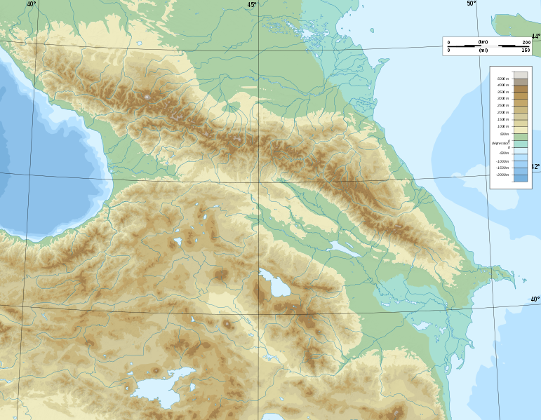
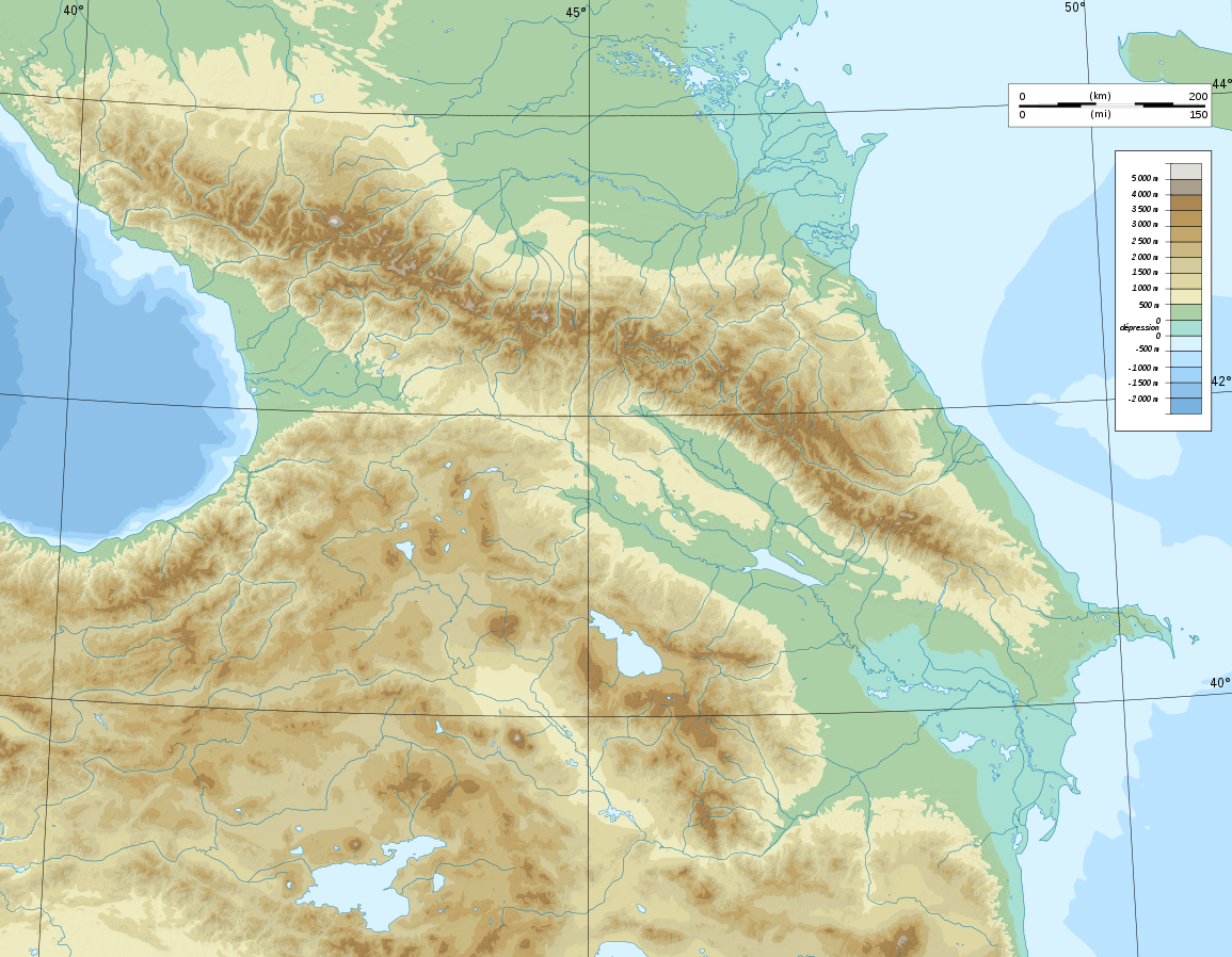
Deutsch: Topographische Karte von Kaukasien, französische Version English: Topographic map in French of Caucasus Français : Carte topographique en français du Caucase |
| తేదీ | |
| మూలం |
English: Own work ; Topographic data from the NASA Shuttle Radar Topography Mission (SRTM3 v.2) (public domain) edited with 3DEM, reprojected in UTM with GDAL (GDAL), and vectorized with Inkscape ; UTM projection ; WGS84 datum ; shaded relief (composite image of N-W, W and N lightning positions) ; Reference used for the additional data : * Rivers, bathymetry : Demis add-on for World Wind (see the approval e-mail and the Demis forum) ; * coast : World data bank II ; Approximate scale of topographic data : 1:1,463,000 ; Note : The shaded relief is a raster image embedded in the SVG file. Français : Création personnelle ; Données topographiques de la NASA Shuttle Radar Topography Mission (SRTM3 v.2) (domaine public) éditées avec 3DEM, reprojetées en UTM avec GDAL et vectorisées avec Inkscape ; projection UTM ; WGS84 datum ; relief ombré (image composite d'éclairages du N-O, O et N) ; Références utilisées pour les données complémentaires : * Rivières, bathymétrie : Demis add-on for World Wind (cf. l'e-mail d'approbation de Demis et le Demis forum) ; * côtes : World data bank II ; Échelle approximative des données topographiques : 1:1 463 000 ; Note : Le relief ombré est une image bitmap embarquée dans le fichier SVG. Approximate geographic limits of the map (3' close) : * SW corner : 38°05'00"N – 39°33'00"E * SE corner : 38°05'00"N – 51°00'00"E * NE corner : 45°00'00"N – 51°00'00"E * NW corner : 45°00'00"N – 39°00'00"E |
| కర్త | Bourrichon - fr:Bourrichon) |
| అనుమతి (ఈ దస్త్రాన్ని పునర్వినియోగించుకోవడం) |
GFDL / Attribution and Share-Alike required |
| ఇతర కూర్పులు |
|


|
This SVG file contains embedded text that can be translated into your language, using any capable SVG editor, text editor or the SVG Translate tool. For more information see: About translating SVG files. |
లైసెన్సింగ్
నేను, ఈ కృతి యొక్క కాపీహక్కుదారుని, దీన్ని ఇందుమూలముగా ఈ లైసెన్సుల క్రింద ప్రచురిస్తున్నాను:

|
ఈ కృతి యొక్క కర్తనైన నేను, ఇక నుండీ ఈ కృతిని కాపీ చేసుకోవడానికి, పంచి పెట్టడానికి మరియు/లేదా మార్పులు-చేర్పులు చేసుకోవడానికి GFDL, లైసెన్సు వెర్షను 1.2 లేదా దాని తరువాత స్వేచ్చా సాఫ్టువేరు ఫౌండేషను విడుదలచేసే ఏ GFDL లైసెన్సు ద్వారా నయినా అనుమతి ఇస్తున్నాను; ఈ కృతిలో మార్చకూడని బాగాలు లేవు, Front-Cover పాఠం లేదు, Back-Cover పాఠం లేదు. ఈ లైసెన్సు యొక్క పత్రం నకలును "జిఎన్యూ ఉచిత డాక్యుమెంటేషను లైసెన్సు" అని పిలుస్తున్న విభాగంలో ఉంది. |
This file is licensed under the Creative Commons Attribution-Share Alike 4.0 International, 3.0 Unported, 2.5 Generic, 2.0 Generic and 1.0 Generic license.
- ఇలా చేసేందుకు మీకు స్వేచ్ఛ ఉంది:
- పంచుకోడానికి – ఈ కృతిని కాపీ చేసుకోవచ్చు, పంపిణీ చేయవచ్చు, ప్రసారమూ చేయవచ్చు
- రీమిక్స్ చేయడానికి – కృతిని అనుకరించడానికి
- క్రింది షరతులకు లోబడి:
- ఆపాదింపు – సముచితమైన శ్రేయస్సును ఇవ్వాలి, లైసెన్సుకు లింకు ఇవ్వాలి, మార్పులేమైనా చేస్తే వాటిని సూచించాలి. అందుకు సముచితమైన పద్ధతి దేన్నైనా అవలంబించవచ్చు. కానీ మీకూ మీ వాడుకకూ హక్కుదారు అనుమతించారు అనే అర్థం వచ్చేటట్లుగా మాత్రం కాదు.
- share alike – మీరు ఈ కృతిని అనుకరిస్తే, మారిస్తే, లేదా మెరుగుపరిస్తే తత్ఫలిత కృతిని ఇదే లైసెన్సు లేదా దీనికి అనుగుణ్యమైన లైసెన్సు క్రింద మాత్రమే పంపిణీ చేయాలి.
పైవాటిలో మీకు నచ్చిన లైసెన్సునును ఎంచుకోవచ్చు.
ఫైలు చరితం
తేదీ/సమయం ను నొక్కి ఆ సమయాన ఫైలు ఎలా ఉండేదో చూడవచ్చు.
| తేదీ/సమయం | నఖచిత్రం | కొలతలు | వాడుకరి | వ్యాఖ్య | |
|---|---|---|---|---|---|
| ప్రస్తుత | 17:16, 9 నవంబరు 2008 | | 1,155 × 898 (4.43 MB) | Bourrichon | |
| 15:59, 8 నవంబరు 2008 |  | 1,155 × 898 (4.43 MB) | Bourrichon | == Summary == {{Information |Description={{de|Topographische Karte von Kaukasien, französische Version}}{{en|Topographic map in French of Caucasus}}{{fr|Carte topographique en français du Caucase}} |Sou |
లింకులు
కింది పేజీలలో ఈ ఫైలుకు లింకులు ఉన్నాయి:
సార్వత్రిక ఫైలు వాడుక
ఈ దస్త్రాన్ని ఈ క్రింది ఇతర వికీలు ఉపయోగిస్తున్నాయి:
- ar.wikipedia.org లో వాడుక
- ast.wikipedia.org లో వాడుక
- av.wikipedia.org లో వాడుక
- az.wikipedia.org లో వాడుక
- Azərbaycan dili
- Muğan düzü
- Araz
- Böyük Qafqaz
- Kür
- Göygöl (göl)
- Bazardüzü
- Şablon:Çay
- Ağrı dağı
- Qarayazı Dövlət Təbiət Qoruğu
- Göygöl Dövlət Təbiət Qoruğu
- İlisu Dövlət Təbiət Qoruğu
- Mingəçevir su anbarı
- Hacıqabul gölü
- Türyançay Dövlət Təbiət Qoruğu
- Talış dağları
- Kürəkçay
- Qabırrıçay
- Qanıxçay
- Sumqayıtçay
- İlandağ
- Göyçə gölü
- Göyəzən dağı
- Şablon:Yer xəritəsi
- Şablon:Yer xəritəsi/doc
- Şablon:Yer xəritəsi+
- Xınalıq dağı
- Qafqaz dağları
- Murovdağ
- Kəpəz dağı
- Sarısu gölü
- Böyükşor gölü
- Maralgöl
- Şablon:Su anbarı
- Şablon:Su anbarı/doc
- Candargöl
- Kazbek dağı
- Şirvan düzü
- Mil düzü
- Batabat gölü
- Beşbarmaq dağı
- Babazənən yüksəkliyi
ఈ దస్త్రపు మరింత సార్వత్రిక వాడుకను చూడండి.