దస్త్రం:CzechRepublic-geographic map-en.svg

ఈ ఫైలు SVG కు చెందిన ఈ మునుజూపు PNG పరిమాణం: 800 × 493 పిక్సెళ్ళు. ఇతర రిజల్యూషన్లు: 320 × 197 పిక్సెళ్ళు | 640 × 394 పిక్సెళ్ళు | 1,024 × 630 పిక్సెళ్ళు | 1,280 × 788 పిక్సెళ్ళు | 2,560 × 1,576 పిక్సెళ్ళు | 1,949 × 1,200 పిక్సెళ్ళు.
అసలు దస్త్రం (SVG ఫైలు, నామమాత్రంగా 1,949 × 1,200 పిక్సెళ్ళు, ఫైలు పరిమాణం: 14.56 MB)
This is a file from the Wikimedia Commons. Information from its description page there is shown below. Commons is a freely licensed media file repository. You can help. |
సారాంశం
| Description |
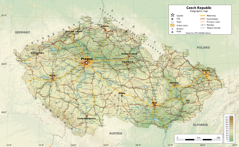
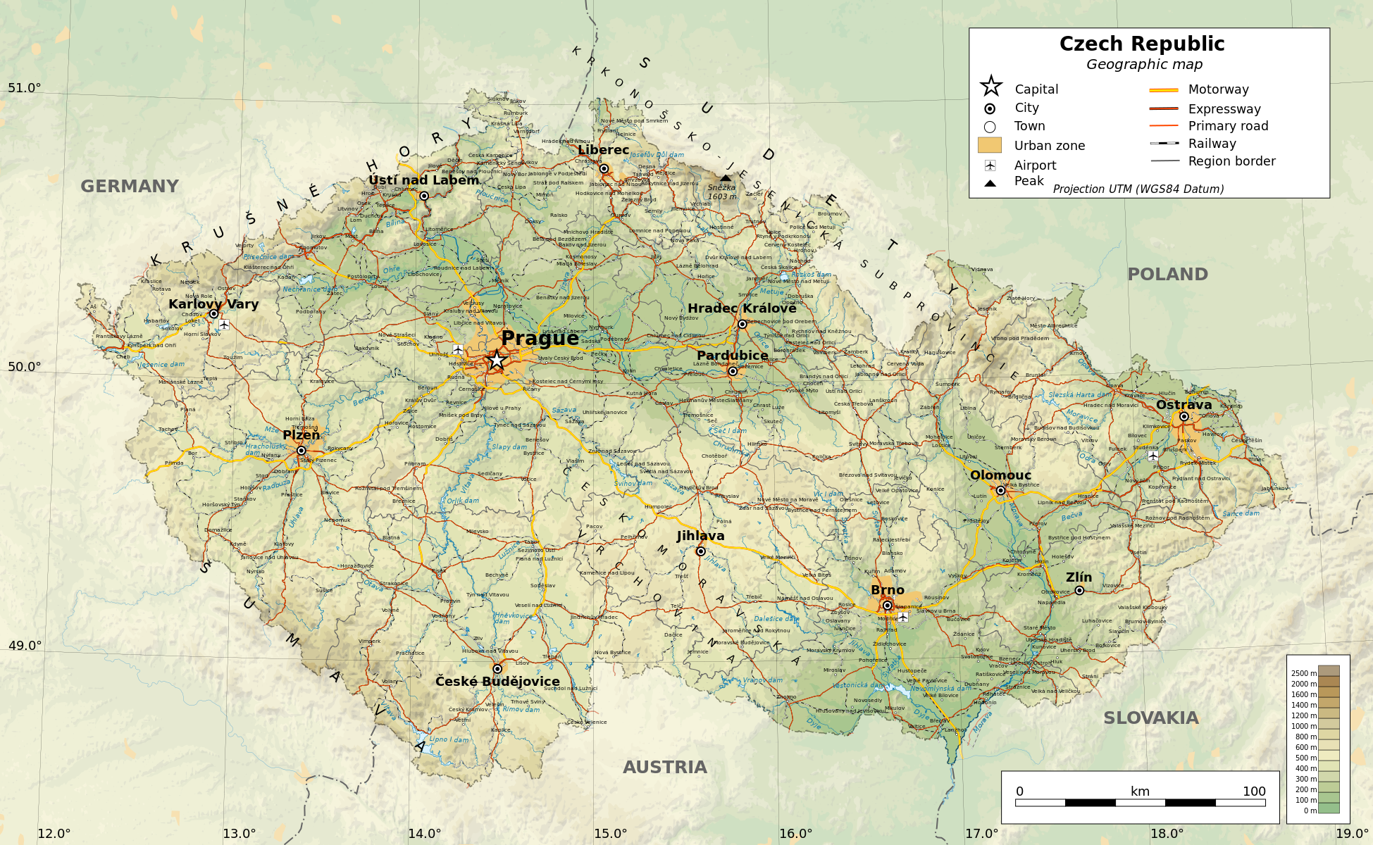
English: Geographic map of the Czech Republic. Geographic limits of the map:
Українська: Топографічна карта Чехії.
|
| తేదీ | |
| మూలం |
స్వంత కృతి
|
| స్రష్ట | |
| అనుమతి (ఈ దస్త్రాన్ని పునర్వినియోగించుకోవడం) |
Any use of this map is subject of the license(s) stated below with the condition that you credit (Wikimedia Commons user: Ikonact) as the author . A message with a reply address would also be greatly appreciated. |
| Georeferencing | If inappropriate please set warp_status = skip to hide. |
| ఇతర కూర్పులు |
|


|

|
This SVG file contains embedded text that can be translated into your language, using any capable SVG editor, text editor or the SVG Translate tool. For more information see: About translating SVG files. |
లైసెన్సింగ్
| This work contains information from OpenStreetMap, which is made available under the Open Database License (ODbL).
The ODbL does not require any particular license for maps produced from ODbL data. Prior to 1 August 2020, map tiles produced by the OpenStreetMap Foundation were licensed under the CC-BY-SA-2.0 license. Maps produced by other people may be subject to other licences. |
నేను, ఈ కృతి యొక్క కాపీహక్కుదారుని, దీన్ని ఈ లైసెన్సు క్రింద ఇందుమూలముగా ప్రచురిస్తున్నాను:
This file is licensed under the Creative Commons Attribution-Share Alike 4.0 International license.
- ఇలా చేసేందుకు మీకు స్వేచ్ఛ ఉంది:
- పంచుకోడానికి – ఈ కృతిని కాపీ చేసుకోవచ్చు, పంపిణీ చేయవచ్చు, ప్రసారమూ చేయవచ్చు
- రీమిక్స్ చేయడానికి – కృతిని అనుకరించడానికి
- క్రింది షరతులకు లోబడి:
- ఆపాదింపు – సముచితమైన శ్రేయస్సును ఇవ్వాలి, లైసెన్సుకు లింకు ఇవ్వాలి, మార్పులేమైనా చేస్తే వాటిని సూచించాలి. అందుకు సముచితమైన పద్ధతి దేన్నైనా అవలంబించవచ్చు. కానీ మీకూ మీ వాడుకకూ హక్కుదారు అనుమతించారు అనే అర్థం వచ్చేటట్లుగా మాత్రం కాదు.
- share alike – మీరు ఈ కృతిని అనుకరిస్తే, మారిస్తే, లేదా మెరుగుపరిస్తే తత్ఫలిత కృతిని ఇదే లైసెన్సు లేదా దీనికి అనుగుణ్యమైన లైసెన్సు క్రింద మాత్రమే పంపిణీ చేయాలి.
ఫైలు చరితం
తేదీ/సమయం ను నొక్కి ఆ సమయాన ఫైలు ఎలా ఉండేదో చూడవచ్చు.
| తేదీ/సమయం | నఖచిత్రం | కొలతలు | వాడుకరి | వ్యాఖ్య | |
|---|---|---|---|---|---|
| ప్రస్తుత | 23:02, 20 డిసెంబరు 2017 | | 1,949 × 1,200 (14.56 MB) | Ikonact | railways cleaned a bit, town names replaced, legend completed |
| 11:36, 14 డిసెంబరు 2017 |  | 1,949 × 1,200 (14.99 MB) | Ikonact | font corrected | |
| 20:20, 29 నవంబరు 2017 |  | 1,949 × 1,200 (14.99 MB) | Ikonact | geography | |
| 20:03, 21 నవంబరు 2017 |  | 1,949 × 1,200 (14.98 MB) | Ikonact | final | |
| 21:14, 19 నవంబరు 2017 |  | 1,949 × 1,200 (14.96 MB) | Ikonact | + railways | |
| 23:07, 15 నవంబరు 2017 |  | 1,949 × 1,200 (15.31 MB) | Ikonact | + reservoir names, admin borders | |
| 22:03, 14 నవంబరు 2017 |  | 1,949 × 1,200 (15.22 MB) | Ikonact | + river names, cities outside of CZ deleted | |
| 22:22, 13 నవంబరు 2017 |  | 1,949 × 1,200 (15.2 MB) | Ikonact | font size | |
| 20:21, 11 నవంబరు 2017 |  | 1,949 × 1,200 (15.22 MB) | Ikonact | =={{int:filedesc}}== {{Information |description={{en|1=Geographic map of Czech Republic. Geographic limits of the map:}} *S: 48.3° N *N: 51.3° N *W: 11.8° W *E: 19.2° W Projection: UTM |date=2017-11-11 |source={{own}} *Source... |
లింకులు
ఈ ఫైలును వాడుతున్న పేజీలు లేవు.
సార్వత్రిక ఫైలు వాడుక
ఈ దస్త్రాన్ని ఈ క్రింది ఇతర వికీలు ఉపయోగిస్తున్నాయి:
- af.wikipedia.org లో వాడుక
- az.wikipedia.org లో వాడుక
- cs.wikipedia.org లో వాడుక
- en.wikipedia.org లో వాడుక
- fr.wikipedia.org లో వాడుక
- glk.wikipedia.org లో వాడుక
- id.wikipedia.org లో వాడుక
- uk.wikipedia.org లో వాడుక