దస్త్రం:Easter Island map-fr.svg

ఈ ఫైలు SVG కు చెందిన ఈ మునుజూపు PNG పరిమాణం: 800 × 569 పిక్సెళ్ళు. ఇతర రిజల్యూషన్లు: 320 × 228 పిక్సెళ్ళు | 640 × 455 పిక్సెళ్ళు | 1,024 × 729 పిక్సెళ్ళు | 1,280 × 911 పిక్సెళ్ళు | 2,560 × 1,821 పిక్సెళ్ళు | 1,750 × 1,245 పిక్సెళ్ళు.
అసలు దస్త్రం (SVG ఫైలు, నామమాత్రంగా 1,750 × 1,245 పిక్సెళ్ళు, ఫైలు పరిమాణం: 878 KB)
This is a file from the Wikimedia Commons. Information from its description page there is shown below. Commons is a freely licensed media file repository. You can help. |
సారాంశం
This image was selected as picture of the day on Wikimedia Commons for 1 December 2008. It was captioned as follows: English: Detailed topographic map in English of Easter Island. Other languages:
Afrikaans: Gedetaileerde topografie van Paaseiland Català: Mapa topogràfic detallat en anglès de l'Illa de Pasqua. Čeština: Detailní topografická mapa Velikonočního ostrova Eesti: Detailne inglisekeelne topograafiline kaart et:Lihavõttesaarest. English: Detailed topographic map in English of Easter Island. Esperanto: detala topografia mapo de la Paskinsulo (jen anglalingva, sed ankaŭ havebla en pluraj aliaj lingvoj) Français : Carte topographique détaillée en anglais de l'île de Pâques Italiano: Mappa topografica dell'Isola di Pasqua, Cile. Nederlands: Engelstalige gedetailleerde topografische kaart van Paaseiland Português: Mapa topográfico detalhado, em Inglês, da Ilha da Páscoa Română: Hartă topografică detaliată, în limba engleză, a insulei Paștelui. Svenska: Detaljerad topografisk karta på engelska över Påskön. Македонски: Детална топографска карта на Велигденскиот Остров на англиски. Русский: Топографическая карта Острова Пасхи 한국어: 이스터 섬의 지형도. 中文: 复活节岛地形图 中文(繁體): 復活節島地形圖 |
| వివరణ |
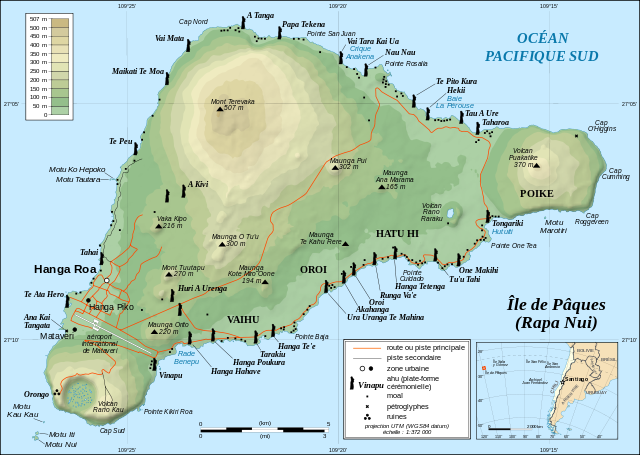
English: Topographic map in French of Easter Island.
Note: The shaded relief is a raster image embedded in the SVG file. Français : Carte topographique en français de l'île de Pâques. Note : les ombres du relief sont une image bitmap embarquée dans le fichier SVG.
|
||
| తేదీ | November 2006 - October 2008 for the new version (see the release note) | ||
| మూలం |
Own work
|
||
| కర్త | Eric Gaba (Sting - fr:Sting) | ||
| అనుమతి (ఈ దస్త్రాన్ని పునర్వినియోగించుకోవడం) |
|
||
| ఇతర కూర్పులు |
Derivative works of this file:
[]
|


![[1]](http://www.waymarker.co.uk/ml/rapanui/map.jpg)
_location_map.svg)
This W3C-unspecified vector image was created with Inkscape .

|
This SVG file contains embedded text that can be translated into your language, using any capable SVG editor, text editor or the SVG Translate tool. For more information see: About translating SVG files. |
లైసెన్సింగ్
నేను, ఈ కృతి యొక్క కాపీహక్కుదారుని, దీన్ని ఈ లైసెన్సు క్రింద ఇందుమూలముగా ప్రచురిస్తున్నాను:
ఈ దస్త్రం క్రియేటివ్ కామన్స్ ఆపాదింపు-యథాతథ పంచుకోలు 2.5 సాధారణం లైసెన్సు క్రింద లభ్యం.
- ఇలా చేసేందుకు మీకు స్వేచ్ఛ ఉంది:
- పంచుకోడానికి – ఈ కృతిని కాపీ చేసుకోవచ్చు, పంపిణీ చేయవచ్చు, ప్రసారమూ చేయవచ్చు
- రీమిక్స్ చేయడానికి – కృతిని అనుకరించడానికి
- క్రింది షరతులకు లోబడి:
- ఆపాదింపు – సముచితమైన శ్రేయస్సును ఇవ్వాలి, లైసెన్సుకు లింకు ఇవ్వాలి, మార్పులేమైనా చేస్తే వాటిని సూచించాలి. అందుకు సముచితమైన పద్ధతి దేన్నైనా అవలంబించవచ్చు. కానీ మీకూ మీ వాడుకకూ హక్కుదారు అనుమతించారు అనే అర్థం వచ్చేటట్లుగా మాత్రం కాదు.
- share alike – మీరు ఈ కృతిని అనుకరిస్తే, మారిస్తే, లేదా మెరుగుపరిస్తే తత్ఫలిత కృతిని ఇదే లైసెన్సు లేదా దీనికి అనుగుణ్యమైన లైసెన్సు క్రింద మాత్రమే పంపిణీ చేయాలి.
ఫైలు చరితం
తేదీ/సమయం ను నొక్కి ఆ సమయాన ఫైలు ఎలా ఉండేదో చూడవచ్చు.
| తేదీ/సమయం | నఖచిత్రం | కొలతలు | వాడుకరి | వ్యాఖ్య | |
|---|---|---|---|---|---|
| ప్రస్తుత | 12:46, 22 ఏప్రిల్ 2010 | | 1,750 × 1,245 (878 KB) | Naturals | Correction mot: Caleta => Crique |
| 12:39, 22 అక్టోబరు 2008 |  | 1,750 × 1,245 (877 KB) | Sting | + scale | |
| 20:02, 21 అక్టోబరు 2008 |  | 1,750 × 1,245 (876 KB) | Sting | Completely new version using other sources ; new standard colors | |
| 01:14, 30 అక్టోబరు 2007 |  | 1,750 × 1,245 (537 KB) | Sting | Some additional info | |
| 13:52, 2 ఏప్రిల్ 2007 |  | 1,750 × 1,245 (537 KB) | Sting | Bug fix (display of some layers) | |
| 02:34, 27 జనవరి 2007 |  | 1,750 × 1,245 (577 KB) | Sting | Colour standard | |
| 22:39, 23 నవంబరు 2006 |  | 1,750 × 1,245 (470 KB) | Sting | Cosmetic text rendering correction | |
| 22:32, 23 నవంబరు 2006 |  | 1,750 × 1,245 (470 KB) | Sting | Last (?) correction (thanks Sodipodi) | |
| 21:53, 23 నవంబరు 2006 |  | 1,750 × 1,245 (432 KB) | Sting | Again (via Sodipodi) | |
| 21:16, 23 నవంబరు 2006 |  | 1,750 × 1,245 (552 KB) | Sting | Again (plain svg) |
లింకులు
ఈ ఫైలును వాడుతున్న పేజీలు లేవు.
సార్వత్రిక ఫైలు వాడుక
ఈ దస్త్రాన్ని ఈ క్రింది ఇతర వికీలు ఉపయోగిస్తున్నాయి:
- ar.wikipedia.org లో వాడుక
- az.wikipedia.org లో వాడుక
- ba.wikipedia.org లో వాడుక
- be.wikipedia.org లో వాడుక
- ca.wikipedia.org లో వాడుక
- cs.wikipedia.org లో వాడుక
- Moai
- Pavel Pavel
- Velikonoční ostrov
- Rano Kau
- Orongo (Velikonoční ostrov)
- Anakena
- Rano Raraku
- Pukao
- Maunga Terevaka
- Poike
- Puna Pau
- Šablona:Velikonoční ostrov
- Jacob Roggeveen
- Katherine Routledge
- Hanga Roa
- Ahu Tongariki
- Ahu Akivi
- Ahu Vai Uri
- Ahu Ko Te Riku
- Ahu Nau Nau
- Maunga Orito
- Rano Aroi
- William Mulloy
- Motu Nui
- Národní park Rapa Nui
- Wikipedista:Pilgrim/Pokusy
- Georg Forster
- Ahu Te Pito Kura
- Rongorongo
- Tahai
- Ahu
- Felipe González Ahedo
- Thor Heyerdahl
- Kuchyně Velikonočního ostrova
- Reimiro
- Jean-Baptiste Dutrou-Bornier
- eo.wikipedia.org లో వాడుక
- fi.wikipedia.org లో వాడుక
- fr.wikipedia.org లో వాడుక
ఈ దస్త్రపు మరింత సార్వత్రిక వాడుకను చూడండి.