దస్త్రం:Ethiopia shaded relief map 1999, CIA.jpg

ఈ మునుజూపు పరిమాణం: 498 × 599 పిక్సెళ్ళు. ఇతర రిజల్యూషన్లు: 199 × 240 పిక్సెళ్ళు | 399 × 480 పిక్సెళ్ళు | 1,010 × 1,215 పిక్సెళ్ళు.
అసలు దస్త్రం (1,010 × 1,215 పిక్సెళ్ళు, ఫైలు పరిమాణం: 222 KB, MIME రకం: image/jpeg)
This is a file from the Wikimedia Commons. Information from its description page there is shown below. Commons is a freely licensed media file repository. You can help. |
సారాంశం
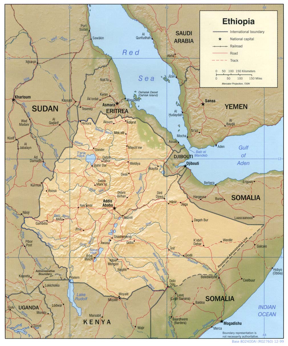
| వివరణ | Shaded relief map of Ethiopia, 1999, produced by the U.S. Central Intelligence Agency. |
| తేదీ | |
| మూలం |
University of Texas Libraries, Perry-Castañeda Library Map Collection: Ethiopia Maps |
| కర్త | CIA |
| ఇతర కూర్పులు |
Derivative works of this file: |
లైసెన్సింగ్
| This image is a work of a Central Intelligence Agency employee, taken or made as part of that person's official duties. As a Work of the United States Government, this image or media is in the public domain in the United States.
|

|
ఫైలు చరితం
తేదీ/సమయం ను నొక్కి ఆ సమయాన ఫైలు ఎలా ఉండేదో చూడవచ్చు.
| తేదీ/సమయం | నఖచిత్రం | కొలతలు | వాడుకరి | వ్యాఖ్య | |
|---|---|---|---|---|---|
| ప్రస్తుత | 11:23, 22 ఫిబ్రవరి 2006 | | 1,010 × 1,215 (222 KB) | Lupo | Shaded relief map of Ethiopia. Source: [http://www.lib.utexas.edu/maps/africa/ethiopia_rel99.jpg] from the [http://www.lib.utexas.edu/maps/ethiopia.html Perry-Castañeda Library Map Collection]. {{PD-USGov-CIA}} Category:Maps of Cameroon |
లింకులు
ఈ ఫైలును వాడుతున్న పేజీలు లేవు.
సార్వత్రిక ఫైలు వాడుక
ఈ దస్త్రాన్ని ఈ క్రింది ఇతర వికీలు ఉపయోగిస్తున్నాయి:
- ar.wikipedia.org లో వాడుక
- ast.wikipedia.org లో వాడుక
- av.wikipedia.org లో వాడుక
- ba.wikipedia.org లో వాడుక
- bg.wikipedia.org లో వాడుక
- br.wikipedia.org లో వాడుక
- bs.wikipedia.org లో వాడుక
- ca.wikipedia.org లో వాడుక
- ckb.wikipedia.org లో వాడుక
- cs.wikipedia.org లో వాడుక
- da.wikipedia.org లో వాడుక
- de.wikinews.org లో వాడుక
- el.wikipedia.org లో వాడుక
- en.wikipedia.org లో వాడుక
- fa.wikipedia.org లో వాడుక
- fr.wikipedia.org లో వాడుక
- gcr.wikipedia.org లో వాడుక
- he.wikipedia.org లో వాడుక
- he.wiktionary.org లో వాడుక
- hr.wiktionary.org లో వాడుక
- id.wikipedia.org లో వాడుక
- io.wikipedia.org లో వాడుక
- it.wikipedia.org లో వాడుక
- jv.wikipedia.org లో వాడుక
- ka.wikipedia.org లో వాడుక
- ku.wikipedia.org లో వాడుక
- la.wikipedia.org లో వాడుక
- ml.wikipedia.org లో వాడుక
- mzn.wikipedia.org లో వాడుక
- nl.wikipedia.org లో వాడుక
- no.wikipedia.org లో వాడుక
- os.wikipedia.org లో వాడుక
- pl.wikipedia.org లో వాడుక
ఈ దస్త్రపు మరింత సార్వత్రిక వాడుకను చూడండి.