దస్త్రం:Lagoons and Reefs of New Caledonia May 10, 2001.jpg

ఈ మునుజూపు పరిమాణం: 800 × 600 పిక్సెళ్ళు. ఇతర రిజల్యూషన్లు: 320 × 240 పిక్సెళ్ళు | 640 × 480 పిక్సెళ్ళు | 1,024 × 768 పిక్సెళ్ళు | 1,280 × 960 పిక్సెళ్ళు | 2,560 × 1,920 పిక్సెళ్ళు | 4,000 × 3,000 పిక్సెళ్ళు.
అసలు దస్త్రం (4,000 × 3,000 పిక్సెళ్ళు, ఫైలు పరిమాణం: 5.58 MB, MIME రకం: image/jpeg)
This is a file from the Wikimedia Commons. Information from its description page there is shown below. Commons is a freely licensed media file repository. You can help. |
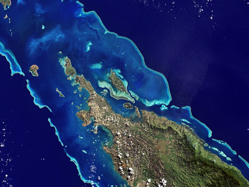
| వివరణ | NASA’s Landsat 7 satellite captured this image of Île Balabio, off the northern tip of Grande Terra, New Caledonia’s main island. In this natural-color image, the islands appear in shades of green and brown—mixtures of vegetation and bare ground. The surrounding waters range in color from pale aquamarine to deep blue, and the color differences result from varying depths. Over coral reef ridges and sand bars, the water is shallowest and palest in color. | |||||
| తేదీ | ||||||
| మూలం | Earth Observatory | |||||
| కర్త | the Enhanced Thematic Mapper Plus on NASA’s Landsat 7 satellite, Jesse Allen, Michon Scott. | |||||
| అనుమతి (ఈ దస్త్రాన్ని పునర్వినియోగించుకోవడం) |
|

ఫైలు చరితం
తేదీ/సమయం ను నొక్కి ఆ సమయాన ఫైలు ఎలా ఉండేదో చూడవచ్చు.
| తేదీ/సమయం | నఖచిత్రం | కొలతలు | వాడుకరి | వ్యాఖ్య | |
|---|---|---|---|---|---|
| ప్రస్తుత | 01:05, 27 జనవరి 2013 | | 4,000 × 3,000 (5.58 MB) | Slick-o-bot | Bot: convert to a non-interlaced jpeg (see bug #17645) |
| 18:22, 27 జూలై 2008 |  | 4,000 × 3,000 (5.02 MB) | CarolSpears | {{Information |Description=NASA’s Landsat 7 satellite captured this image of Île Balabio, off the northern tip of Grande Terra, New Caledonia’s main island. In this natural-color image, the islands appear in shades of green and brown—mixtures of ve |
లింకులు
కింది పేజీలలో ఈ ఫైలుకు లింకులు ఉన్నాయి:
సార్వత్రిక ఫైలు వాడుక
ఈ దస్త్రాన్ని ఈ క్రింది ఇతర వికీలు ఉపయోగిస్తున్నాయి:
- ar.wikipedia.org లో వాడుక
- ast.wikipedia.org లో వాడుక
- ca.wikipedia.org లో వాడుక
- ceb.wikipedia.org లో వాడుక
- cs.wikipedia.org లో వాడుక
- de.wikipedia.org లో వాడుక
- en.wikipedia.org లో వాడుక
- en.wikibooks.org లో వాడుక
- es.wikipedia.org లో వాడుక
- eu.wikipedia.org లో వాడుక
- fi.wikipedia.org లో వాడుక
- fr.wikipedia.org లో వాడుక
- gl.wikipedia.org లో వాడుక
- he.wikipedia.org లో వాడుక
- hr.wikipedia.org లో వాడుక
- id.wikipedia.org లో వాడుక
- it.wikipedia.org లో వాడుక
- ka.wikipedia.org లో వాడుక
- ko.wikipedia.org లో వాడుక
- lt.wikipedia.org లో వాడుక
- lv.wikipedia.org లో వాడుక
- mt.wikipedia.org లో వాడుక
- ne.wikipedia.org లో వాడుక
- nl.wikipedia.org లో వాడుక
- no.wikipedia.org లో వాడుక
ఈ దస్త్రపు మరింత సార్వత్రిక వాడుకను చూడండి.