దస్త్రం:Map of the Territorial Waters of the Atlantic and Indian Ocean.png

ఈ మునుజూపు పరిమాణం: 800 × 459 పిక్సెళ్ళు. ఇతర రిజల్యూషన్లు: 320 × 184 పిక్సెళ్ళు | 640 × 367 పిక్సెళ్ళు | 1,024 × 588 పిక్సెళ్ళు | 1,280 × 735 పిక్సెళ్ళు | 2,919 × 1,676 పిక్సెళ్ళు.
అసలు దస్త్రం (2,919 × 1,676 పిక్సెళ్ళు, ఫైలు పరిమాణం: 588 KB, MIME రకం: image/png)
This is a file from the Wikimedia Commons. Information from its description page there is shown below. Commons is a freely licensed media file repository. You can help. |

|
This map image could be re-created using vector graphics as an SVG file. This has several advantages; see Commons:Media for cleanup for more information. If an SVG form of this image is available, please upload it and afterwards replace this template with
{{vector version available|new image name}}.
It is recommended to name the SVG file “Map of the Territorial Waters of the Atlantic and Indian Ocean.svg”—then the template Vector version available (or Vva) does not need the new image name parameter. |
సారాంశం
| వివరణ |
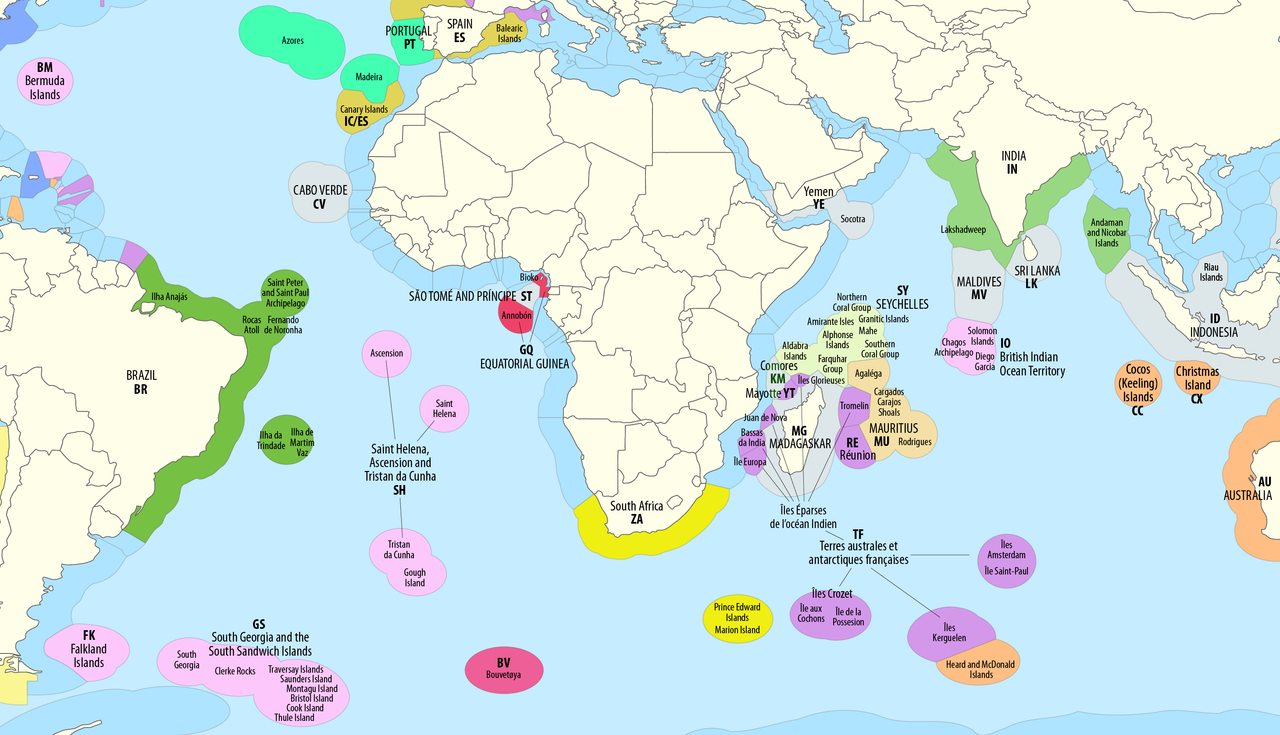
Deutsch: Ausschließliche Wirtschaftszonen (EEZ) im Atlantischen und im Indischen Ozean
English: Territorial waters (EEZ) of the Atlantic and Indian Ocean |
| తేదీ | see file history |
| మూలం | Own work using: this map by B1mbo |
| కర్త | Maximilian Dörrbecker (Chumwa) |
| అనుమతి (ఈ దస్త్రాన్ని పునర్వినియోగించుకోవడం) |
నేను, ఈ కృతి యొక్క కాపీహక్కుదారుని, దీన్ని ఈ లైసెన్సు క్రింద ఇందుమూలముగా ప్రచురిస్తున్నాను: ఈ దస్త్రం క్రియేటివ్ కామన్స్ ఆపాదింపు-యథాతథ పంచుకోలు 2.5 సాధారణం లైసెన్సు క్రింద లభ్యం.
Sie dürfen das Bild zu den folgenden Bedingungen nutzen:
|
| ఇతర కూర్పులు |
|


ఫైలు చరితం
తేదీ/సమయం ను నొక్కి ఆ సమయాన ఫైలు ఎలా ఉండేదో చూడవచ్చు.
| తేదీ/సమయం | నఖచిత్రం | కొలతలు | వాడుకరి | వ్యాఖ్య | |
|---|---|---|---|---|---|
| ప్రస్తుత | 09:06, 2 మే 2023 | | 2,919 × 1,676 (588 KB) | Lasunncty | Comoros not part of France |
| 05:46, 4 అక్టోబరు 2018 |  | 2,919 × 1,676 (799 KB) | Chumwa | corr | |
| 19:18, 29 ఆగస్టు 2018 |  | 2,919 × 1,676 (797 KB) | Chumwa | {{Information |Description= {{de|1=Ausschließliche Wirtschaftszonen (EEZ) im Atlantischen und im Indischen Ozean}} {{en|1=Territorial waters (EEZ) of the Atlantic and Indian Ocean}} |Source = {{own using}} this map by {{U|B1mbo}} |Date = see file history |Author = Maximilian Dörrbecker (Chumwa) |Permission={{self|cc-by-sa-2.5}} Sie dürfen das Bild zu den folgenden Bedingungen nutzen: * Sie müssen den Namen des... |
లింకులు
కింది పేజీలలో ఈ ఫైలుకు లింకులు ఉన్నాయి:
సార్వత్రిక ఫైలు వాడుక
ఈ దస్త్రాన్ని ఈ క్రింది ఇతర వికీలు ఉపయోగిస్తున్నాయి:
- af.wikipedia.org లో వాడుక
- ar.wikipedia.org లో వాడుక
- ast.wikipedia.org లో వాడుక
- de.wikipedia.org లో వాడుక
- en.wikipedia.org లో వాడుక
- es.wikipedia.org లో వాడుక
- fr.wikipedia.org లో వాడుక
- hi.wikipedia.org లో వాడుక
- it.wikipedia.org లో వాడుక
- ja.wikipedia.org లో వాడుక
- ru.wikipedia.org లో వాడుక