దస్త్రం:Napier06.jpg

ఈ మునుజూపు పరిమాణం: 800 × 593 పిక్సెళ్ళు. ఇతర రిజల్యూషన్లు: 320 × 237 పిక్సెళ్ళు | 640 × 474 పిక్సెళ్ళు | 1,024 × 758 పిక్సెళ్ళు | 1,280 × 948 పిక్సెళ్ళు.
అసలు దస్త్రం (1,280 × 948 పిక్సెళ్ళు, ఫైలు పరిమాణం: 149 KB, MIME రకం: image/jpeg)
This is a file from the Wikimedia Commons. Information from its description page there is shown below. Commons is a freely licensed media file repository. You can help. |
సారాంశం
Informations in English
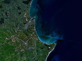
- Description: This is a NASA World Wind composite satellite image of New Zealand, showing Napier, Hastings, and Cape Kidnappers.
Informationen auf Deutsch
- Beschreibung: Dieses NASA World Wind-Bild zeigt den südlichen Teil der Hawke's Bay, insbesondere die Städte Napier und Hastings sowie Cape Kidnappers in Neuseeland.
లైసెన్సింగ్
| This image is in the public domain because it is a screenshot from NASA’s globe software World Wind using a public domain layer, such as Blue Marble, MODIS, Landsat, SRTM, USGS or GLOBE.
|
 |
ఫైలు చరితం
తేదీ/సమయం ను నొక్కి ఆ సమయాన ఫైలు ఎలా ఉండేదో చూడవచ్చు.
| తేదీ/సమయం | నఖచిత్రం | కొలతలు | వాడుకరి | వ్యాఖ్య | |
|---|---|---|---|---|---|
| ప్రస్తుత | 21:04, 18 మార్చి 2006 | | 1,280 × 948 (149 KB) | 2000 | ===Informations in English=== *Description: NASA World Wind composite satellite image of New Zealand, showing Napier, Hastings, and Cape Kidnappers. ===Informationen auf Deutsch=== *Beschreibung: Dieses NASA World Wind-Bild zeigt d |
లింకులు
ఈ ఫైలును వాడుతున్న పేజీలు లేవు.
సార్వత్రిక ఫైలు వాడుక
ఈ దస్త్రాన్ని ఈ క్రింది ఇతర వికీలు ఉపయోగిస్తున్నాయి:
- de.wikipedia.org లో వాడుక
- en.wikipedia.org లో వాడుక
- eo.wikipedia.org లో వాడుక
- fr.wikipedia.org లో వాడుక
- hi.wikipedia.org లో వాడుక
- it.wikipedia.org లో వాడుక
- nn.wikipedia.org లో వాడుక
- www.wikidata.org లో వాడుక
- zh.wikipedia.org లో వాడుక