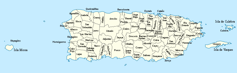
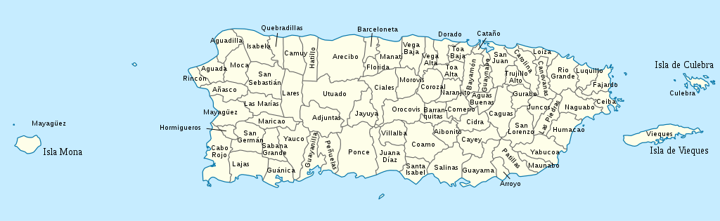
దస్త్రం:USA Puerto Rico labeled.svg

ఈ ఫైలు SVG కు చెందిన ఈ మునుజూపు PNG పరిమాణం: 800 × 246 పిక్సెళ్ళు. ఇతర రిజల్యూషన్లు: 320 × 98 పిక్సెళ్ళు | 640 × 197 పిక్సెళ్ళు | 1,024 × 315 పిక్సెళ్ళు | 1,280 × 393 పిక్సెళ్ళు | 2,560 × 786 పిక్సెళ్ళు | 1,058 × 325 పిక్సెళ్ళు.
అసలు దస్త్రం (SVG ఫైలు, నామమాత్రంగా 1,058 × 325 పిక్సెళ్ళు, ఫైలు పరిమాణం: 171 KB)
This is a file from the Wikimedia Commons. Information from its description page there is shown below. Commons is a freely licensed media file repository. You can help. |
సారాంశం


.svg)


_(Paris_zoom).svg)
.svg)
,_administrative_divisions_-_de_-_colored_(multizoom).svg)
_-_colored.svg)
.svg)
,_administrative_divisions_-_Nmbrs_(multizoom).svg)
,_administrative_divisions_-_de_-_colored.svg)
_-_de_-_colored.svg)

.svg)

.svg)
నేను, ఈ కృతి యొక్క కాపీహక్కుదారుని, దీన్ని ఈ లైసెన్సు క్రింద ఇందుమూలముగా ప్రచురిస్తున్నాను:
ఈ దస్త్రం క్రియేటివ్ కామన్స్ Attribution-Share Alike 3.0 Unported లైసెన్సు క్రింద లభ్యం.
- ఇలా చేసేందుకు మీకు స్వేచ్ఛ ఉంది:
- పంచుకోడానికి – ఈ కృతిని కాపీ చేసుకోవచ్చు, పంపిణీ చేయవచ్చు, ప్రసారమూ చేయవచ్చు
- రీమిక్స్ చేయడానికి – కృతిని అనుకరించడానికి
- క్రింది షరతులకు లోబడి:
- ఆపాదింపు – సముచితమైన శ్రేయస్సును ఇవ్వాలి, లైసెన్సుకు లింకు ఇవ్వాలి, మార్పులేమైనా చేస్తే వాటిని సూచించాలి. అందుకు సముచితమైన పద్ధతి దేన్నైనా అవలంబించవచ్చు. కానీ మీకూ మీ వాడుకకూ హక్కుదారు అనుమతించారు అనే అర్థం వచ్చేటట్లుగా మాత్రం కాదు.
- share alike – మీరు ఈ కృతిని అనుకరిస్తే, మారిస్తే, లేదా మెరుగుపరిస్తే తత్ఫలిత కృతిని ఇదే లైసెన్సు లేదా దీనికి అనుగుణ్యమైన లైసెన్సు క్రింద మాత్రమే పంపిణీ చేయాలి.
అసలు ఎక్కింపుల చిట్టా
This image is a derivative work of the following images:
- USA Puerto Rico location map.svg licensed with Cc-by-sa-3.0
- 2009-06-19T07:13:05Z NordNordWest 1058x595 (117123 Bytes) Based on the raster image: [[:Image:Feather.jpg]] * {{Français}} Plume * {{English}} Feather * {{Español}} Pluma == Licensing == {{GFDL-self}} [[Category:Icons]] resizeresizeresizeresizeresizeresizeresizeresizeresize••••
Uploaded with derivativeFX
ఫైలు చరితం
తేదీ/సమయం ను నొక్కి ఆ సమయాన ఫైలు ఎలా ఉండేదో చూడవచ్చు.
| తేదీ/సమయం | నఖచిత్రం | కొలతలు | వాడుకరి | వ్యాఖ్య | |
|---|---|---|---|---|---|
| ప్రస్తుత | 15:53, 26 మార్చి 2010 | 1,058 × 325 (171 KB) | Kmusser | spelling | |
| 20:44, 24 మార్చి 2010 | 1,058 × 325 (171 KB) | Kmusser | increased font size | ||
| 20:33, 24 మార్చి 2010 | 1,058 × 325 (170 KB) | Kmusser | {{Information |Description={{de|Positionskarte von Puerto Rico, USA}} Quadratische Plattkarte, N-S-Streckung 105 %. Geographische Begrenzung der Karte: * N: 19.0° N * S: 17.5° N * W: 68.0° W * O: 65.2° W {{en|Location m |
లింకులు
ఈ ఫైలును వాడుతున్న పేజీలు లేవు.
సార్వత్రిక ఫైలు వాడుక
ఈ దస్త్రాన్ని ఈ క్రింది ఇతర వికీలు ఉపయోగిస్తున్నాయి:
- de.wikipedia.org లో వాడుక
- en.wikipedia.org లో వాడుక
- es.wikipedia.org లో వాడుక
- fa.wikipedia.org లో వాడుక
- frr.wikipedia.org లో వాడుక
- fr.wikipedia.org లో వాడుక
- is.wikipedia.org లో వాడుక
- it.wikipedia.org లో వాడుక
- ja.wikipedia.org లో వాడుక
- ka.wikipedia.org లో వాడుక
- lt.wikipedia.org లో వాడుక
- nl.wikipedia.org లో వాడుక
- pnb.wikipedia.org లో వాడుక
- pt.wikipedia.org లో వాడుక
- ru.wikipedia.org లో వాడుక
- su.wikipedia.org లో వాడుక
- th.wikipedia.org లో వాడుక
- trv.wikipedia.org లో వాడుక
- ur.wikipedia.org లో వాడుక
- vi.wikipedia.org లో వాడుక
- zh.wikipedia.org లో వాడుక