దస్త్రం:Yangtze River Map.png
మరింత స్పష్టమైన బొమ్మ లేదు.
Yangtze_River_Map.png (576 × 355 పిక్సెళ్ళు, ఫైలు పరిమాణం: 123 KB, MIME రకం: image/png)
This is a file from the Wikimedia Commons. Information from its description page there is shown below. Commons is a freely licensed media file repository. You can help. |
సారాంశం
| వివరణ |
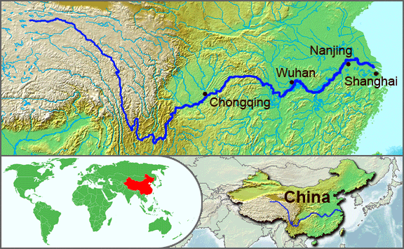
English: The underlying topographic maps used in this image come from the Demis Web Map Server, and are in the public domain. The world locator map is derived from :Image:BlankMap-World.png. I added the feature layers myself. —Papayoung ☯ 20:57, 1 October 2005 (UTC) |
| తేదీ | 1 అక్టోబరు 2005 (original upload date) |
| మూలం | Transferred from en.wikipedia to Commons by Common Good using CommonsHelper. |
| కర్త | The original uploader was Papayoung at ఇంగ్లీష్ వికీపీడియా. |
| ఇతర కూర్పులు |
|
.JPG)
లైసెన్సింగ్
| ఈ దస్త్రం క్రియేటివ్ కామన్స్ Attribution-Share Alike 3.0 Unported లైసెన్సు క్రింద లభ్యం. Subject to disclaimers. | ||
| ||
| GFDL లైసెన్సు తాజాకరణలో భాగంగా ఈ దస్త్రానికి ఈ లైసెన్సింగు ట్యాగుని చేర్చారు. |

|
ఈ కృతి యొక్క కర్తనైన నేను, ఇక నుండీ ఈ కృతిని కాపీ చేసుకోవడానికి, పంచి పెట్టడానికి మరియు/లేదా మార్పులు-చేర్పులు చేసుకోవడానికి GFDL, లైసెన్సు వెర్షను 1.2 లేదా దాని తరువాత స్వేచ్చా సాఫ్టువేరు ఫౌండేషను విడుదలచేసే ఏ GFDL లైసెన్సు ద్వారా నయినా అనుమతి ఇస్తున్నాను; ఈ కృతిలో మార్చకూడని బాగాలు లేవు, Front-Cover పాఠం లేదు, Back-Cover పాఠం లేదు. ఈ లైసెన్సు యొక్క పత్రం నకలును "జిఎన్యూ ఉచిత డాక్యుమెంటేషను లైసెన్సు" అని పిలుస్తున్న విభాగంలో ఉంది. Subject to disclaimers. |
అసలు ఎక్కింపుల చిట్టా
The original description page was here. All following user names refer to en.wikipedia.
- 2005-10-01 20:51 Papayoung 576×355× (125604 bytes) The underlying topographic maps used in this image come from the [http://www2.demis.nl/mapserver/mapper.asp Demis Web Map Server], and are in the public domain. The world locator map is derived from [[Commons:Image:BlankMap-World.png|BlankMap-World.png]].
- 2005-09-25 22:57 Papayoung 936×363× (221574 bytes) The underlying topographic maps used in this image come from the [http://www2.demis.nl/mapserver/mapper.asp Demis Web Map Server], and are in the public domain. I added the feature layers myself. —~~~~
ఫైలు చరితం
తేదీ/సమయం ను నొక్కి ఆ సమయాన ఫైలు ఎలా ఉండేదో చూడవచ్చు.
| తేదీ/సమయం | నఖచిత్రం | కొలతలు | వాడుకరి | వ్యాఖ్య | |
|---|---|---|---|---|---|
| ప్రస్తుత | 20:30, 7 మే 2009 | | 576 × 355 (123 KB) | File Upload Bot (Magnus Manske) | {{BotMoveToCommons|en.wikipedia|year={{subst:CURRENTYEAR}}|month={{subst:CURRENTMONTHNAME}}|day={{subst:CURRENTDAY}}}} {{Information |Description={{en|The underlying topographic maps used in this image come from the [http://www2.demis.nl/mapserver/mapper |
లింకులు
కింది పేజీలలో ఈ ఫైలుకు లింకులు ఉన్నాయి:
సార్వత్రిక ఫైలు వాడుక
ఈ దస్త్రాన్ని ఈ క్రింది ఇతర వికీలు ఉపయోగిస్తున్నాయి:
- af.wikipedia.org లో వాడుక
- als.wikipedia.org లో వాడుక
- am.wikipedia.org లో వాడుక
- ary.wikipedia.org లో వాడుక
- ast.wikipedia.org లో వాడుక
- as.wikipedia.org లో వాడుక
- azb.wikipedia.org లో వాడుక
- be-tarask.wikipedia.org లో వాడుక
- bh.wikipedia.org లో వాడుక
- bn.wikipedia.org లో వాడుక
- bo.wikipedia.org లో వాడుక
- br.wikipedia.org లో వాడుక
- cs.wikipedia.org లో వాడుక
- de.wikipedia.org లో వాడుక
- en.wikipedia.org లో వాడుక
- en.wikinews.org లో వాడుక
- es.wikipedia.org లో వాడుక
- et.wikipedia.org లో వాడుక
- eu.wikipedia.org లో వాడుక
- fi.wikipedia.org లో వాడుక
- fo.wikipedia.org లో వాడుక
- frr.wikipedia.org లో వాడుక
- fr.wikipedia.org లో వాడుక
- fr.wikivoyage.org లో వాడుక
- fr.wiktionary.org లో వాడుక
- fy.wikipedia.org లో వాడుక
- hi.wikipedia.org లో వాడుక
- hu.wikipedia.org లో వాడుక
- hy.wikipedia.org లో వాడుక
- hyw.wikipedia.org లో వాడుక
- id.wikipedia.org లో వాడుక
- ilo.wikipedia.org లో వాడుక
- incubator.wikimedia.org లో వాడుక
- io.wikipedia.org లో వాడుక
- it.wikipedia.org లో వాడుక
- ja.wikipedia.org లో వాడుక
- ka.wikipedia.org లో వాడుక
- ko.wikipedia.org లో వాడుక
- ku.wikipedia.org లో వాడుక
- la.wikipedia.org లో వాడుక
- lfn.wikipedia.org లో వాడుక
ఈ దస్త్రపు మరింత సార్వత్రిక వాడుకను చూడండి.