దస్త్రం:Yeniseirivermap.png
ఈ మునుజూపు పరిమాణం: 601 × 600 పిక్సెళ్ళు. ఇతర రిజల్యూషన్లు: 240 × 240 పిక్సెళ్ళు | 481 × 480 పిక్సెళ్ళు | 988 × 986 పిక్సెళ్ళు.
అసలు దస్త్రం (988 × 986 పిక్సెళ్ళు, ఫైలు పరిమాణం: 325 KB, MIME రకం: image/png)
This is a file from the Wikimedia Commons. Information from its description page there is shown below. Commons is a freely licensed media file repository. You can help. |

|
This map image could be re-created using vector graphics as an SVG file. This has several advantages; see Commons:Media for cleanup for more information. If an SVG form of this image is available, please upload it and afterwards replace this template with
{{vector version available|new image name}}.
It is recommended to name the SVG file “Yeniseirivermap.svg”—then the template Vector version available (or Vva) does not need the new image name parameter. |
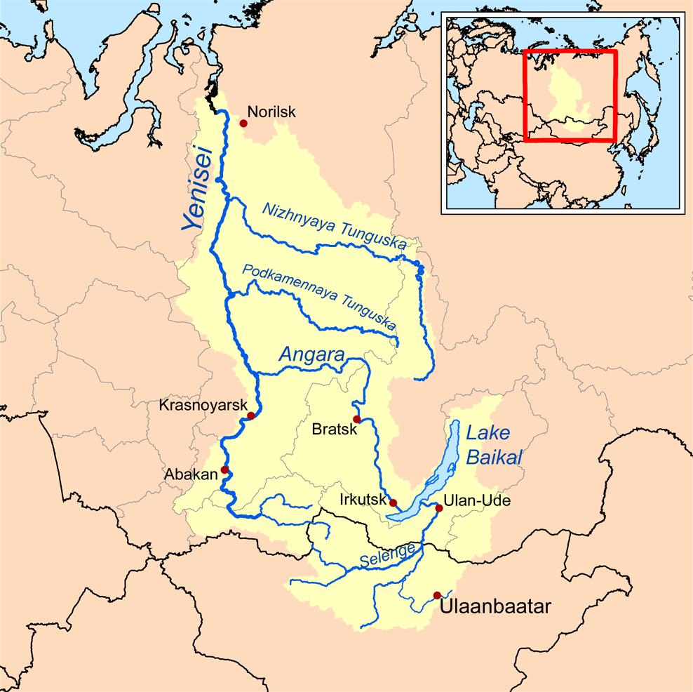
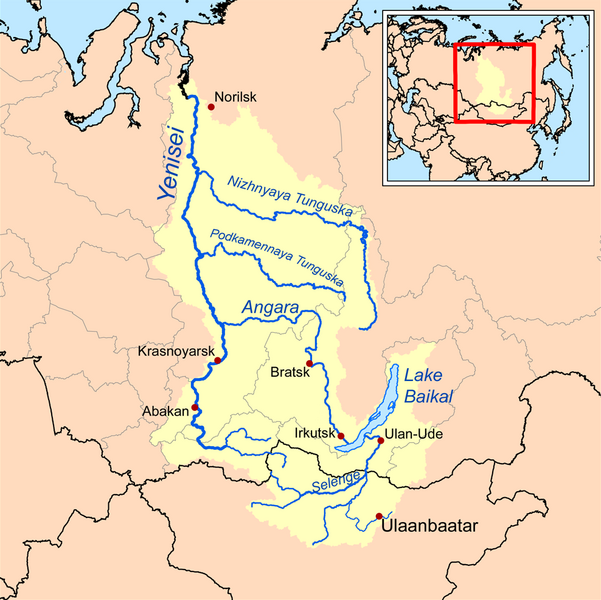
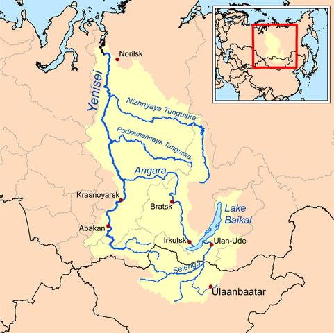
| వివరణ | This is a map of the Yenisei River drainage basin, with national borders added. |
| తేదీ | |
| మూలం | Own work using Digital Chart of the World and GTOPO data. |
| కర్త | Kmusser |
|
|
This map image could be re-created using vector graphics as an SVG file. This has several advantages; see Commons:Media for cleanup for more information. If an SVG form of this image is available, please upload it and afterwards replace this template with
{{vector version available|new image name}}.
It is recommended to name the SVG file “Yeniseirivermap.svg”—then the template Vector version available (or Vva) does not need the new image name parameter. |
నేను, ఈ కృతి యొక్క కాపీహక్కుదారుని, దీన్ని ఈ లైసెన్సు క్రింద ఇందుమూలముగా ప్రచురిస్తున్నాను:
ఈ దస్త్రం క్రియేటివ్ కామన్స్ Attribution-Share Alike 3.0 Unported లైసెన్సు క్రింద లభ్యం.
- ఇలా చేసేందుకు మీకు స్వేచ్ఛ ఉంది:
- పంచుకోడానికి – ఈ కృతిని కాపీ చేసుకోవచ్చు, పంపిణీ చేయవచ్చు, ప్రసారమూ చేయవచ్చు
- రీమిక్స్ చేయడానికి – కృతిని అనుకరించడానికి
- క్రింది షరతులకు లోబడి:
- ఆపాదింపు – సముచితమైన శ్రేయస్సును ఇవ్వాలి, లైసెన్సుకు లింకు ఇవ్వాలి, మార్పులేమైనా చేస్తే వాటిని సూచించాలి. అందుకు సముచితమైన పద్ధతి దేన్నైనా అవలంబించవచ్చు. కానీ మీకూ మీ వాడుకకూ హక్కుదారు అనుమతించారు అనే అర్థం వచ్చేటట్లుగా మాత్రం కాదు.
- share alike – మీరు ఈ కృతిని అనుకరిస్తే, మారిస్తే, లేదా మెరుగుపరిస్తే తత్ఫలిత కృతిని ఇదే లైసెన్సు లేదా దీనికి అనుగుణ్యమైన లైసెన్సు క్రింద మాత్రమే పంపిణీ చేయాలి.
See also
ఫైలు చరితం
తేదీ/సమయం ను నొక్కి ఆ సమయాన ఫైలు ఎలా ఉండేదో చూడవచ్చు.
| తేదీ/సమయం | నఖచిత్రం | కొలతలు | వాడుకరి | వ్యాఖ్య | |
|---|---|---|---|---|---|
| ప్రస్తుత | 13:32, 26 అక్టోబరు 2013 | | 988 × 986 (325 KB) | Ras67 | cropped, opt. |
| 18:10, 15 సెప్టెంబరు 2008 |  | 1,000 × 1,000 (414 KB) | Kmusser | {{Information |Description=This is a map of the Yenisei River drainage basin. |Source=Own work using http://www.maproom.psu.edu/dcw/ Digital Chart of the World and [[http://edc.usgs.gov/products/elevation/gtopo30/gtopo30.html GTO |
లింకులు
కింది పేజీలలో ఈ ఫైలుకు లింకులు ఉన్నాయి:
సార్వత్రిక ఫైలు వాడుక
ఈ దస్త్రాన్ని ఈ క్రింది ఇతర వికీలు ఉపయోగిస్తున్నాయి:
- af.wikipedia.org లో వాడుక
- am.wikipedia.org లో వాడుక
- ar.wikipedia.org లో వాడుక
- arz.wikipedia.org లో వాడుక
- ast.wikipedia.org లో వాడుక
- azb.wikipedia.org లో వాడుక
- be.wikipedia.org లో వాడుక
- bh.wikipedia.org లో వాడుక
- bn.wikipedia.org లో వాడుక
- bs.wikipedia.org లో వాడుక
- ca.wikipedia.org లో వాడుక
- cs.wikipedia.org లో వాడుక
- cy.wikipedia.org లో వాడుక
- da.wikipedia.org లో వాడుక
- de.wikipedia.org లో వాడుక
- en.wikipedia.org లో వాడుక
- Lake Baikal
- Angara
- Yenisey
- Nizhnyaya Tunguska
- New Order (Nazism)
- Soyot
- User:Kmusser/Images
- Tungusic peoples
- Dené–Yeniseian languages
- List of Russian explorers
- Demid Pyanda
- Wikipedia:Graphics Lab/Illustration workshop/Archive/Jan 2011
- Axis powers negotiations on the division of Asia
- Physochlaina
- Yenisei Inscriptions
- eo.wikipedia.org లో వాడుక
ఈ దస్త్రపు మరింత సార్వత్రిక వాడుకను చూడండి.