దస్త్రం:Wisconsin geographic provinces.svg

ఈ ఫైలు SVG కు చెందిన ఈ మునుజూపు PNG పరిమాణం: 585 × 600 పిక్సెళ్ళు. ఇతర రిజల్యూషన్లు: 234 × 240 పిక్సెళ్ళు | 468 × 480 పిక్సెళ్ళు | 749 × 768 పిక్సెళ్ళు | 998 × 1,024 పిక్సెళ్ళు | 1,997 × 2,048 పిక్సెళ్ళు | 1,015 × 1,041 పిక్సెళ్ళు.
అసలు దస్త్రం (SVG ఫైలు, నామమాత్రంగా 1,015 × 1,041 పిక్సెళ్ళు, ఫైలు పరిమాణం: 213 KB)
This is a file from the Wikimedia Commons. Information from its description page there is shown below. Commons is a freely licensed media file repository. You can help. |
సారాంశం
| వివరణ |
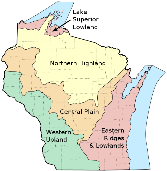
English: Map of the geographic regions of Wisconsin. |
| తేదీ | |
| మూలం |
Own work based on the following sources:
|
| కర్త | User:Jua Cha |
| ఇతర కూర్పులు | Derivative works of this file: Wisconsin geographic provinces ru.svg |
లైసెన్సింగ్
| నేను, ఈ కృతి యొక్క కాపీహక్కుదారుని, ఈ కృతిని సార్వజనీనం'గా విడుదల చేస్తున్నాను. ఇది ప్రపంచవ్యాప్తంగా వర్తిస్తుంది. కొన్ని దేశాల్లో ఇది చట్టబద్ధంగా సాధ్యంకాకపోవచ్చు; అయితే: ఈ కృతిని ఎటువంటి షరతులు లేకుండా, అట్టి షరతులు చట్టం వల్ల తప్పనిసరి అయితే తప్ప, ఏ ఉద్దేశానికైనా ఉపయోగించుకునే హక్కును ఎవరికైనా నేను ప్రదానం చేస్తున్నాను. |
ఫైలు చరితం
తేదీ/సమయం ను నొక్కి ఆ సమయాన ఫైలు ఎలా ఉండేదో చూడవచ్చు.
| తేదీ/సమయం | నఖచిత్రం | కొలతలు | వాడుకరి | వ్యాఖ్య | |
|---|---|---|---|---|---|
| ప్రస్తుత | 14:24, 16 మార్చి 2010 | | 1,015 × 1,041 (213 KB) | Jua Cha | increased border width |
| 04:33, 16 మార్చి 2010 |  | 1,015 × 1,041 (213 KB) | Jua Cha | {{Information |Description={{en|1=Map of the geographic regions of Wisconsin.}} |Source=Own work based on the following sources: *Base map for state and county boundaries: File:Map of Wisconsin highlighting Adams County.svg by [[User:Dbenbenn|Da |
లింకులు
కింది పేజీలలో ఈ ఫైలుకు లింకులు ఉన్నాయి:
సార్వత్రిక ఫైలు వాడుక
ఈ దస్త్రాన్ని ఈ క్రింది ఇతర వికీలు ఉపయోగిస్తున్నాయి:
- ar.wikipedia.org లో వాడుక
- arz.wikipedia.org లో వాడుక
- de.wikipedia.org లో వాడుక
- en.wikipedia.org లో వాడుక
- et.wikipedia.org లో వాడుక
- eu.wikipedia.org లో వాడుక
- fr.wikipedia.org లో వాడుక
- fy.wikipedia.org లో వాడుక
- hu.wikipedia.org లో వాడుక
- ja.wikipedia.org లో వాడుక
- ro.wikipedia.org లో వాడుక