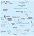
దస్త్రం:Kiribati-Caroline-highlighted.PNG
Kiribati-Caroline-highlighted.PNG (300 × 322 పిక్సెళ్ళు, ఫైలు పరిమాణం: 57 KB, MIME రకం: image/png)
ఫైలు చరితం
తేదీ/సమయం ను నొక్కి ఆ సమయాన ఫైలు ఎలా ఉండేదో చూడవచ్చు.
| తేదీ/సమయం | నఖచిత్రం | కొలతలు | వాడుకరి | వ్యాఖ్య | |
|---|---|---|---|---|---|
| ప్రస్తుత | 20:57, 28 ఏప్రిల్ 2007 |  | 300 × 322 (57 KB) | Alfonso"~commonswiki | {{Information |Description=Adapted version of the post-1995 South Pacific section of en::Image:Kr-map.png, with en:Caroline Island highlighted. |Source=Originally from [http://en.wikipedia.org en.wikipedia]; description page is/was [http://en.wi |
లింకులు
కింది పేజీలలో ఈ ఫైలుకు లింకులు ఉన్నాయి:
సార్వత్రిక ఫైలు వాడుక
ఈ దస్త్రాన్ని ఈ క్రింది ఇతర వికీలు ఉపయోగిస్తున్నాయి:
- ar.wikipedia.org లో వాడుక
- ca.wikipedia.org లో వాడుక
- de.wikipedia.org లో వాడుక
- he.wikipedia.org లో వాడుక
- ko.wikipedia.org లో వాడుక
- pt.wikipedia.org లో వాడుక
- th.wikipedia.org లో వాడుక
- zh.wikipedia.org లో వాడుక
