దస్త్రం:Map Telangana Districts Shaded.png
మరింత స్పష్టమైన బొమ్మ లేదు.
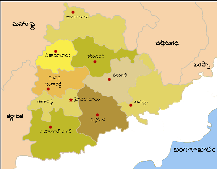
Map_Telangana_Districts_Shaded.png (734 × 572 పిక్సెళ్ళు, ఫైలు పరిమాణం: 87 KB, MIME రకం: image/png)
Summary మార్చు
| Description |
Telangana Districts map shaded with labels in Telugu |
|---|---|
| Source |
I made this based on దస్త్రం:Map AP all Districts Shaded.png |
| Date |
2014-02-27 |
| Author | |
| Permission (Reusing this file) |
See below.
|
Licensing మార్చు
I, the copyright holder of this work, hereby publish it under the following licenses:
You may select the license of your choice.
|

ఫైలు చరితం
తేదీ/సమయం ను నొక్కి ఆ సమయాన ఫైలు ఎలా ఉండేదో చూడవచ్చు.
| తేదీ/సమయం | నఖచిత్రం | కొలతలు | వాడుకరి | వ్యాఖ్య | |
|---|---|---|---|---|---|
| ప్రస్తుత | 03:58, 28 ఫిబ్రవరి 2014 | | 734 × 572 (87 KB) | వైజాసత్య (చర్చ | రచనలు) | ఫైల్ ఎక్కింపు విజర్డు- స్వంతంగా తయారుచేసిన ఫైల్ |
ఈ దస్త్రాన్ని మీరు తిరగరాయలేరు.
లింకులు
ఈ ఫైలును వాడుతున్న పేజీలు లేవు.