దస్త్రం:Pluto-map-hs-2010-06-c180.jpg

ఈ మునుజూపు పరిమాణం: 600 × 600 పిక్సెళ్ళు. ఇతర రిజల్యూషన్లు: 240 × 240 పిక్సెళ్ళు | 480 × 480 పిక్సెళ్ళు | 768 × 768 పిక్సెళ్ళు | 1,200 × 1,200 పిక్సెళ్ళు.
అసలు దస్త్రం (1,200 × 1,200 పిక్సెళ్ళు, ఫైలు పరిమాణం: 195 KB, MIME రకం: image/jpeg)
This is a file from the Wikimedia Commons. Information from its description page there is shown below. Commons is a freely licensed media file repository. You can help. |
సారాంశం
| వివరణ |
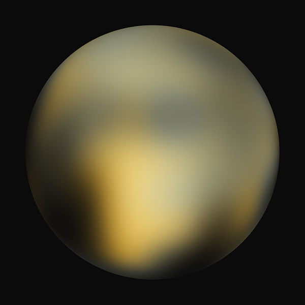
English: A best-fit color image/map of Pluto generated with the Hubble Space Telescope and advanced computers. It is unknown if the brightness differences are mountains, craters, or polar caps. |
| తేదీ | |
| మూలం | Hubblesite STScI-2010-06 (New Hubble Maps of Pluto Show Surface Changes; 180 degree Longitude) |
| కర్త | NASA, ESA, and Marc W. Buie (Southwest Research Institute) |
| అనుమతి (ఈ దస్త్రాన్ని పునర్వినియోగించుకోవడం) |
Any web pages, publications, or any other published use of these maps should provide a legible credit line consistent with the medium that states: "Images are courtesy of Marc W. Buie, Southwest Research Institute" |
లైసెన్సింగ్
| This file is in the public domain in the United States because it was solely created by NASA. NASA copyright policy states that "NASA material is not protected by copyright unless noted". (See Template:PD-USGov, NASA copyright policy page or JPL Image Use Policy.) | ||
 |
Warnings:
|
| Annotations | This image is annotated: View the annotations at Commons |
ఫైలు చరితం
తేదీ/సమయం ను నొక్కి ఆ సమయాన ఫైలు ఎలా ఉండేదో చూడవచ్చు.
| తేదీ/సమయం | నఖచిత్రం | కొలతలు | వాడుకరి | వ్యాఖ్య | |
|---|---|---|---|---|---|
| ప్రస్తుత | 23:42, 4 ఫిబ్రవరి 2010 | | 1,200 × 1,200 (195 KB) | Kheider | == Summary == {{Information |Description={{en|1=A best-fit color image/map of Pluto generated with the Hubble Space Telescope and advanced computers. It is unknown if the brightness differences are mountains, |
లింకులు
కింది పేజీలలో ఈ ఫైలుకు లింకులు ఉన్నాయి:
సార్వత్రిక ఫైలు వాడుక
ఈ దస్త్రాన్ని ఈ క్రింది ఇతర వికీలు ఉపయోగిస్తున్నాయి:
- ar.wikipedia.org లో వాడుక
- be.wikipedia.org లో వాడుక
- cs.wikipedia.org లో వాడుక
- cs.wikiversity.org లో వాడుక
- de.wikipedia.org లో వాడుక
- en.wikipedia.org లో వాడుక
- User:JohnOwens
- User:Clementi
- User:Steve Farrell
- User:DJRaveN4x
- User:Mitternacht90
- User:5aret/5aret's userboxes2
- User:Jimbobalina2005~enwiki
- User:Maelstromm
- User:Mckinlayr
- User:Andante1980
- User:Girla PurpleHeart
- User:Rwflammang
- User:Mathmagic
- User:Rursus
- User:Rkeysone
- User:MissionControl
- User:Buurma
- User:Thaimodz
- User:Lass Lethe
- User:Fjbfour
- User:Rursus/Pluto Dont Care Dwarf Planet Not
- User:Mekmtl
- User:Catalyst2007
- User:Praveen pillay
- User:Steve Farrell/userboxes
- User:Nincubus99x
- User:Cotard
- User:Mendors
- User:Derg999
- User:Radman622
- User:Pulsar06
- User:Themcman1/Userboxes
- User:Saber girl08/userboxen
- User:Andante1980/userbox
- User:Pastel kitten
- User:Countincr
- User:JCSeer
- User:Truncatedcone
- User:DareonClearwater
- User:LadyMage
- User:Samurai3
- User:Mandrke/UserBoxes
- User:Taskforce 58
ఈ దస్త్రపు మరింత సార్వత్రిక వాడుకను చూడండి.